پرونده:Airports in Norway map.svg

حجم پیشنمایش PNG این SVG file:۵۰۱ × ۵۲۶ پیکسل کیفیتهای دیگر: ۲۲۹ × ۲۴۰ پیکسل | ۴۵۷ × ۴۸۰ پیکسل | ۷۳۱ × ۷۶۸ پیکسل | ۹۷۵ × ۱٬۰۲۴ پیکسل | ۱٬۹۵۱ × ۲٬۰۴۸ پیکسل.
پروندهٔ اصلی (پروندهٔ اسویجی، با ابعاد ۵۰۱ × ۵۲۶ پیکسل، اندازهٔ پرونده: ۱۶۶ کیلوبایت)
این پرونده در ویکیانبار موجود است. محتویات صفحهٔ توصیف آن در زیر نمایش داده میشود. |
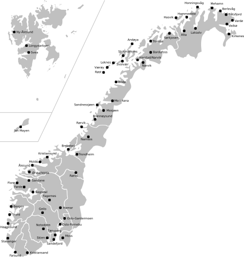
| توضیح | Map of Norway with all current and former public and military airports. This excludes private airports without scheduled services. Note: Svalbard and Jan Mayen are not to scale, and not geographically correctly located in relation to each other and mainland Norway. The accuracy of the map makes accurate placement of the airports sometimes a little off. |
| تاریخ | (UTC) |
| منبع | |
| پدیدآور |
|
این پرونده با اجازهنامهٔ کریتیو کامانز Attribution-Share Alike 3.0 سازگار نشده منتشر شده است.
- شما اجازه دارید:
- برای به اشتراک گذاشتن – برای کپی، توزیع و انتقال اثر
- تلفیق کردن – برای انطباق اثر
- تحت شرایط زیر:
- انتساب – شما باید اعتبار مربوطه را به دست آورید، پیوندی به مجوز ارائه دهید و نشان دهید که آیا تغییرات ایجاد شدهاند یا خیر. شما ممکن است این کار را به هر روش منطقی انجام دهید، اما نه به هر شیوهای که پیشنهاد میکند که مجوزدهنده از شما یا استفادهتان حمایت کند.
- انتشار مشابه – اگر این اثر را تلفیق یا تبدیل میکنید، یا بر پایه آن اثری دیگر خلق میکنید، میبایست مشارکتهای خود را تحت مجوز یکسان یا مشابه با ا اصل آن توزیع کنید.
سیاهه بارگذاری اصلی
This image is a derivative work of the following images:
- File:Norway_counties_blank.svg licensed with Cc-by-sa-2.5
- 2008-07-16T09:52:07Z ZorroIII 256x256 (84546 Bytes) Correct county code for Telemark
- 2007-09-21T21:39:11Z Marmelad 256x256 (84546 Bytes) added information about regions
- 2007-09-21T21:24:01Z Marmelad 256x256 (84348 Bytes) forgot to remove example colouring
- 2007-09-21T21:23:01Z Marmelad 256x256 (84340 Bytes) {{Information |Description=Blank map of Norwegian counties, used e.g. to create locator maps. |Source=Based on [[:Image:Norway counties.svg]] |Date=2007-09-21 |Author=[[User:Marmelad|Marmelad]] |Permission= {{cc-by-sa-2.5}}
- File:Svalbard_outline.svg licensed with PD-self
- 2009-04-28T10:05:31Z Arsenikk 200x265 (39847 Bytes) {{Information |Description={{en|1=Vector outline map of Svalbard, Norway.}} |Source=Own work by uploader |Author=[[User:Arsenikk|Arsenikk]] |Date=2009-04-29 |Permission= |other_versions= }} [[Category:Maps of Svalbard]] [[C
- File:Jan_Mayen_outline.svg licensed with PD-self
- 2009-09-12T10:29:46Z Arsenikk 294x267 (8401 Bytes) {{Information |Description=Blank map of Jan Mayen (Norway) |Source=*[[:File:Jan_Mayen_blank.jpg|]] |Date=2009-09-12 10:28 (UTC) |Author=*[[:File:Jan_Mayen_blank.jpg|]]: Alfanje *derivative work: ~~~ |Permission=see below |oth
Uploaded with derivativeFX
تاریخچهٔ پرونده
روی تاریخ/زمانها کلیک کنید تا نسخهٔ مربوط به آن هنگام را ببینید.
| تاریخ/زمان | بندانگشتی | ابعاد | کاربر | توضیح | |
|---|---|---|---|---|---|
| کنونی | ۲ مهٔ ۲۰۲۱، ساعت ۱۱:۲۳ | | ۵۰۱ در ۵۲۶ (۱۶۶ کیلوبایت) | BIL | I moved some airports slightly to reflect their actual position |
| ۱۲ سپتامبر ۲۰۰۹، ساعت ۱۲:۱۵ |  | ۵۰۱ در ۵۲۶ (۱۷۰ کیلوبایت) | Arsenikk | {{Information |Description=Map of Norway with all current and former public and military airports. This excludes private airports without scheduled services. Note: Svalbard and Jan Mayen are not to scale, and not geographically correctly located in relati |
کاربرد پرونده
صفحهٔ زیر از این تصویر استفاده میکند:
کاربرد سراسری پرونده
ویکیهای دیگر زیر از این پرونده استفاده میکنند:
- کاربرد در en.wikipedia.org
- کاربرد در fr.wikipedia.org
- کاربرد در it.wikipedia.org
- کاربرد در no.wikipedia.org
- کاربرد در uk.wikipedia.org
- کاربرد در zh.wikipedia.org