پرونده:Dust Storm over Bolivia.jpg

پروندهٔ اصلی (۳٬۴۰۰ × ۴٬۰۰۰ پیکسل، اندازهٔ پرونده: ۱٫۹۸ مگابایت، نوع MIME پرونده: image/jpeg)
این پرونده در ویکیانبار موجود است. محتویات صفحهٔ توصیف آن در زیر نمایش داده میشود. |
خلاصه
| توضیح |
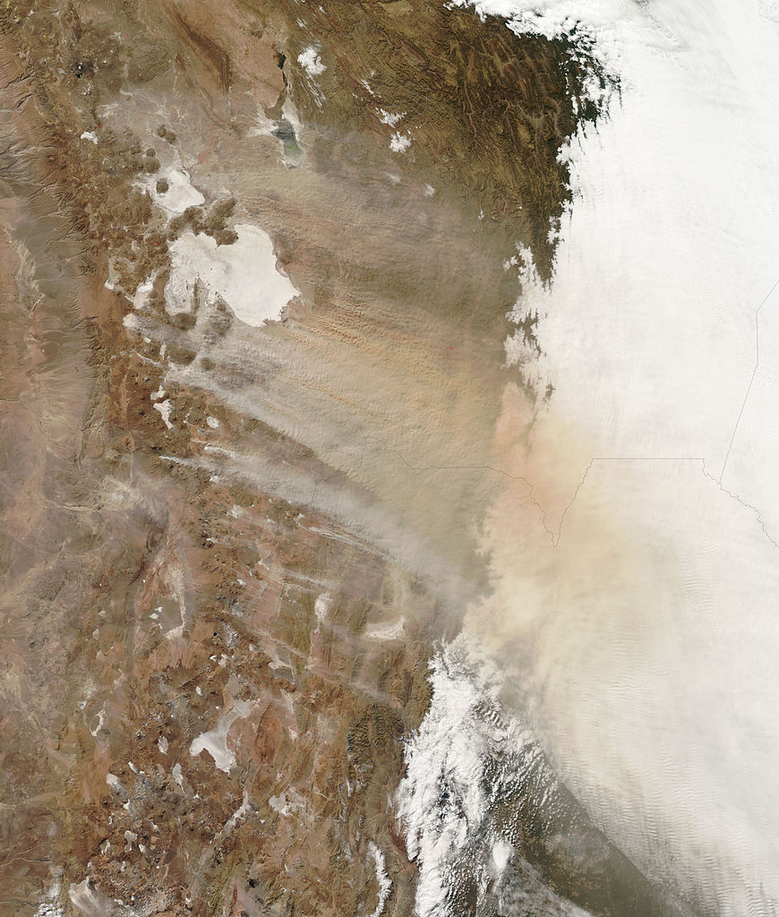
English: Strong winds whip thick clouds of dust across the Bolivian highlands in this photo-like image. Much of the pale dust along the southern edge of the storm is coming from small white spots, salt pans (dry lake beds), south and south-west of Salar de Uyuni, but little or no dust appears to be blowing off the large salt pans, Salar de Uyuni and Salar de Coipasa. Instead, the dust is multi-colored, pointing to a variety of different soil types. Though the region is typically dry, El Niño brought even drier conditions in late 2009 and 2010. By July, much of Bolivia was in the grip of severe drought, particularly in the south-east. The lack of rainfall may have contributed to the dusty conditions seen in the image.
|
| تاریخ | |
| منبع | NASA Earth Observatory |
| پدیدآور | Jeff Schmaltz |
Image captured by the Moderate Resolution Imaging Spectroradiometer (MODIS) on NASA’s Aqua satellite.
اجازهنامه
| این پرونده در مالکیت عمومی قرار دارد چرا که توسط ناسا ایجاد شده است. سیاست حق تکثیر ناسا بیان میکند که «مواد ناسا با حق تکثیر محافظت نمیشوند، مگراینکه ذکر شده باشد». (Template:PD-USGov، صفحهٔ سیاست حق تکثیر ناسا یا سیاست جیپیال استفاده از تصاویر را ببینید.) | ||
 |
هشدارها:
|
| برچسبها | این نگاره برچسپگذاری شدهاست: برچسپها را در ویکیانبار مشاهده کنید |
تاریخچهٔ پرونده
روی تاریخ/زمانها کلیک کنید تا نسخهٔ مربوط به آن هنگام را ببینید.
| تاریخ/زمان | بندانگشتی | ابعاد | کاربر | توضیح | |
|---|---|---|---|---|---|
| کنونی | ۲۰ ژوئیهٔ ۲۰۱۰، ساعت ۱۳:۰۹ | | ۳٬۴۰۰ در ۴٬۰۰۰ (۱٫۹۸ مگابایت) | Originalwana | {{Information |Description={{en|1=Strong winds whip thick clouds of dust across the Bolivian highlands in this photo-like image. Much of the pale dust along the southern edge of the storm is coming from small white spots, salt p |
کاربرد پرونده
صفحهٔ زیر از این تصویر استفاده میکند:
کاربرد سراسری پرونده
ویکیهای دیگر زیر از این پرونده استفاده میکنند:
- کاربرد در ml.wikipedia.org