پرونده:Hazel.gif
تفکیکپذیری بالاتری در دسترس نیست.
Hazel.gif (۳۰۴ × ۲۷۲ پیکسل، اندازهٔ پرونده: ۳۰ کیلوبایت، نوع MIME پرونده: image/gif، ۰٫۲ ثانیه)
این پرونده در ویکیانبار موجود است. محتویات صفحهٔ توصیف آن در زیر نمایش داده میشود. |
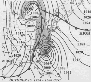
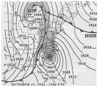
| توضیح | 15 UTC map of October 1954 showing Hurricane Hazel and the meteorological set-up. | |||
| تاریخ | ||||
| منبع | NOAA analysis created by Paul Kocin, of NOAA’s National Weather Service. It can be found at Environment Canada and at NOAA pages. This map is included in this article about Hazel by the Canadian Hurricane Center and this one by the National Weather Service Eastern Region Headquarters. | |||
| پدیدآور | NOAA | |||
| اجازهنامه (استفادهٔ مجدد از این پرونده) |
|
تاریخچهٔ پرونده
روی تاریخ/زمانها کلیک کنید تا نسخهٔ مربوط به آن هنگام را ببینید.
| تاریخ/زمان | بندانگشتی | ابعاد | کاربر | توضیح | |
|---|---|---|---|---|---|
| کنونی | ۱۳ مارس ۲۰۱۰، ساعت ۱۶:۳۲ | | ۳۰۴ در ۲۷۲ (۳۰ کیلوبایت) | Maxim | removed border |
| ۲ آوریل ۲۰۰۷، ساعت ۰۷:۲۳ |  | ۳۱۲ در ۲۷۷ (۳۲ کیلوبایت) | Pierre cb | {{Hurricane auto track map|type=Hurricane|name=Hazel (1954)|source=NHC}} H {{Information |Description= 15 UTC map of October 1954 showing Hurricane Hazel and the meteorological set-up. |Source= [http://www.atl.e |
کاربرد پرونده
صفحهٔ زیر از این تصویر استفاده میکند:
کاربرد سراسری پرونده
ویکیهای دیگر زیر از این پرونده استفاده میکنند:
- کاربرد در en.wikipedia.org
- کاربرد در eo.wikipedia.org
- کاربرد در es.wikipedia.org
- کاربرد در fr.wikipedia.org
- کاربرد در pt.wikipedia.org
- کاربرد در zh.wikipedia.org