پرونده:Juniperus communis range map.gif
تفکیکپذیری بالاتری در دسترس نیست.
Juniperus_communis_range_map.gif (۶۶۴ × ۵۸۰ پیکسل، اندازهٔ پرونده: ۱۹ کیلوبایت، نوع MIME پرونده: image/gif)
این پرونده در ویکیانبار موجود است. محتویات صفحهٔ توصیف آن در زیر نمایش داده میشود. |
خلاصه
| توضیح |
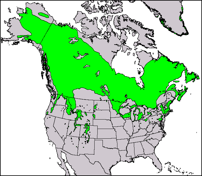
English: This North American range map of Juniperus communis, the common juniper, was published in a USGS publication: Conifers. Climate-Vegetation Atlas of North America. USGS. Retrieved on 2007-11-11. Maps and ArcView shapefiles can also be downloaded here: Little, Jr., Elbert L. Atlas. USGS. Archived from the original on 2007-07-17. Retrieved on 2007-11-11. |
|||
| تاریخ | ||||
| منبع | Thompson, Robert S.; Katherine H. Anderson and Patrick J. Bartlein (۱۹۹۹) Atlas of Relations Between Climatic Parameters and Distributions of Important Trees and Shrubs in North America، U.S. Geological Survey (Professional Paper 1650 A&B) | |||
| پدیدآور | Robert S. Thompson, Katherine H. Anderson, and Patrick J. Bartlein | |||
| اجازهنامه (استفادهٔ مجدد از این پرونده) |
|
|||
| دیگر نسخهها |
This and other maps were originally produced by Elbert L. Little, Jr. of the U.S. Department of Agriculture's Forest Service.  |
| Page | Caption |
|---|---|
| Species distribution | A species range map represents the region where individuals of a species can be found. This is the North American range map of Juniperus communis, the common juniper. |
اجازهنامه
سیاهه بارگذاری اصلی
صفحهٔ اصلی توضیحات اینجابود. همهٔ نامهای کاربر زیر به en.wikipedia اشاره دارند.
| تاریخ/زمان | ابعاد | کاربر | توضیح |
|---|---|---|---|
| 2010-12-29 14:39:43 | 664 × 580 | Threelovemonkeys | {{Information |Description = This is a species range map of Juniperus communis, published in a USGS publication. |Source = Robert S. Thompson, Katherine H. Anderson and Patrick J. Bartlein. 1999. Atlas of Relations Between Climatic Parameters |
تاریخچهٔ پرونده
روی تاریخ/زمانها کلیک کنید تا نسخهٔ مربوط به آن هنگام را ببینید.
| تاریخ/زمان | بندانگشتی | ابعاد | کاربر | توضیح | |
|---|---|---|---|---|---|
| کنونی | ۱۱ آوریل ۲۰۱۷، ساعت ۰۱:۲۵ | | ۶۶۴ در ۵۸۰ (۱۹ کیلوبایت) | FastilyClone | Transferred from en.wikipedia (MTC!) |
کاربرد پرونده
صفحهٔ زیر از این تصویر استفاده میکند:
کاربرد سراسری پرونده
ویکیهای دیگر زیر از این پرونده استفاده میکنند:
- کاربرد در en.wikipedia.org
- کاربرد در uk.wikipedia.org
- کاربرد در vi.wikipedia.org
- کاربرد در zh.wikipedia.org