پرونده:Kitchen-21-Russia-Amur-2817.jpg

اندازهٔ این پیشنمایش: ۸۰۰ × ۶۰۰ پیکسل. کیفیتهای دیگر: ۳۲۰ × ۲۴۰ پیکسل | ۶۴۰ × ۴۸۰ پیکسل | ۱٬۰۲۴ × ۷۶۸ پیکسل | ۱٬۲۸۰ × ۹۶۰ پیکسل | ۲٬۵۶۰ × ۱٬۹۲۰ پیکسل.
پروندهٔ اصلی (۲٬۵۶۰ × ۱٬۹۲۰ پیکسل، اندازهٔ پرونده: ۲٫۰۳ مگابایت، نوع MIME پرونده: image/jpeg)
این پرونده در ویکیانبار موجود است. محتویات صفحهٔ توصیف آن در زیر نمایش داده میشود. |
| توضیح |
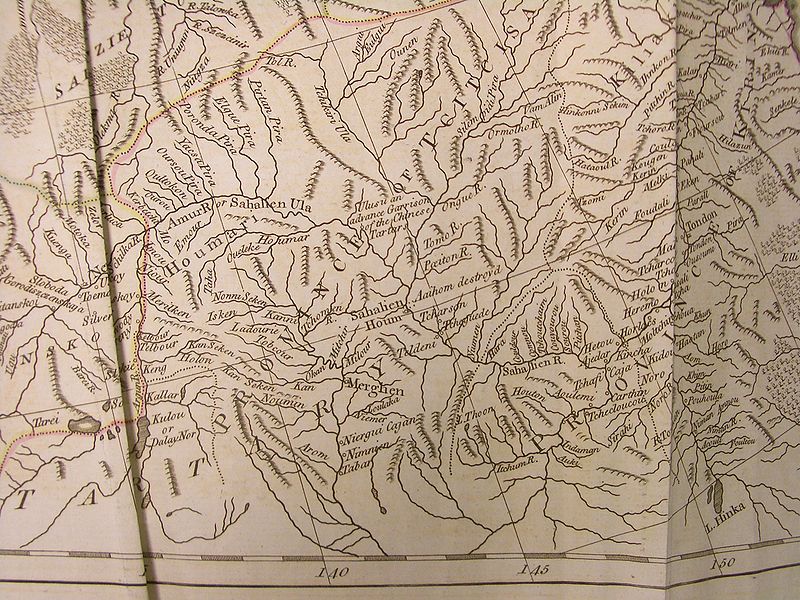
English: A fragment of the map of Russian Empire (pages 21-22), said to be based on d'Anville's work, in Thomas Kithen's "Atlas describing the Whole Universe"
English: The upper and middle Amur region, then part of "Chinese Tartary", and the adjacent parts of Russian Empire |
||||||||||||||||||||
| تاریخ | |||||||||||||||||||||
| منبع |
English: "A General Atlas describing the whole Universe, being a Compleat and New Collection of the most approved Maps extant; Corrected with utmost Care, and augmented from the latest Discoveries; the whole thing being an Improvement of the Maps of d'Anville and Robert. Engraved in the best Manner on Sixty-Two Copper Plates, By Thomas Kitchen, Senior, and Others". "London: Printed for Robert Sayer, Map and Printseller, at No. 53, in Fleet-Street. MDCCLXXIII" (i.e., 1773). Each map in the atlas has its particular author indicated as well.
Русский: "Общий атлас всей Вселенной", изданный в Лондоне в 1773 г. Издатель Томас Китчен. |
||||||||||||||||||||
| پدیدآور |
|
||||||||||||||||||||
| اجازهنامه (استفادهٔ مجدد از این پرونده) |
Author died more than 70 years ago - public domain | ||||||||||||||||||||

|
این اثر در کشورهایی و مناطقی که مدت زمان حق تکثیر، عمر پدیدآورنده بعلاوه 100 سال یا کمتر بعد از مرگ او است، در مالکیت عمومی قرار دارد. | |
| این پرونده تحت قانون حق تکثیر محدودیت آزاد منتشر شده که شامل تمامی حقوق مربوطه و حقوق نزدیک به آن میشود. | |
تاریخچهٔ پرونده
روی تاریخ/زمانها کلیک کنید تا نسخهٔ مربوط به آن هنگام را ببینید.
| تاریخ/زمان | بندانگشتی | ابعاد | کاربر | توضیح | |
|---|---|---|---|---|---|
| کنونی | ۵ آوریل ۲۰۰۹، ساعت ۰۷:۵۱ | | ۲٬۵۶۰ در ۱٬۹۲۰ (۲٫۰۳ مگابایت) | Vmenkov | {{Information |Description={{en|A fragment of the map of Russian Empire (pages 21-22), said to be based on d'Anville's work, in Thomas Kithen's "Atlas describing the Whole Universe"}} {{en|The upper and Middle Amur region, then part of "Chinese Tartary"} |
کاربرد پرونده
صفحههای زیر از این تصویر استفاده میکنند:
کاربرد سراسری پرونده
ویکیهای دیگر زیر از این پرونده استفاده میکنند:
- کاربرد در arz.wikipedia.org
- کاربرد در bg.wikipedia.org
- کاربرد در ca.wikipedia.org
- کاربرد در ceb.wikipedia.org
- کاربرد در cs.wikipedia.org
- کاربرد در en.wikipedia.org
- کاربرد در et.wikipedia.org
- کاربرد در it.wikipedia.org
- کاربرد در pl.wikipedia.org
- کاربرد در ru.wikipedia.org
- کاربرد در sv.wikipedia.org
- کاربرد در ur.wikipedia.org
- کاربرد در vi.wikipedia.org
- کاربرد در www.wikidata.org
- کاربرد در zh.wikipedia.org