پرونده:MapaMacau1912.jpg
اندازهٔ این پیشنمایش: ۴۱۶ × ۵۹۹ پیکسل. کیفیتهای دیگر: ۱۶۷ × ۲۴۰ پیکسل | ۶۳۱ × ۹۰۸ پیکسل.
پروندهٔ اصلی (۶۳۱ × ۹۰۸ پیکسل، اندازهٔ پرونده: ۸۱ کیلوبایت، نوع MIME پرونده: image/jpeg)
این پرونده در ویکیانبار موجود است. محتویات صفحهٔ توصیف آن در زیر نمایش داده میشود. |
خلاصه
| توضیح |
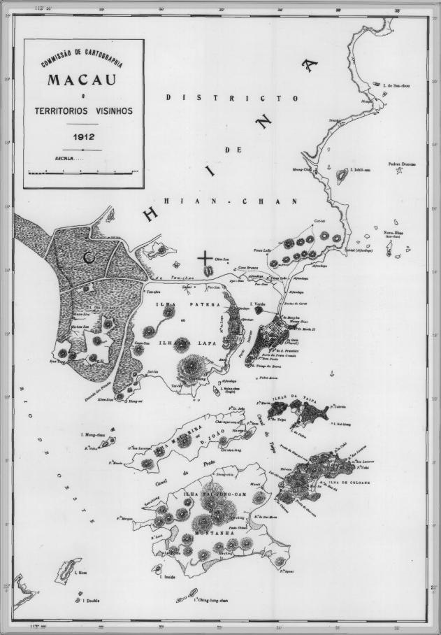
English: This is a map of Macau and is surrounded territories in 1912. In that time, the Portuguese Colony of Macau is formed by the Peninsula de Macau, Taipa and Coloane islands. Macau also have a great influence on the islands of Lapa, D. João and Montanha, located on the west of the Portuguese Colony of Macau. See here for original color version. |
| تاریخ | |
| منبع | |
| پدیدآور |
اجازهنامه
This work is from an official work of Macau and is in the public domain in Macau and possibly other jurisdictions. See here for the type of material that are in the Public domain in Chinese and Portuguese (official languages of Macau), plus English (not an official language of Macau).
|
 | |
| برچسبها | این نگاره برچسپگذاری شدهاست: برچسپها را در ویکیانبار مشاهده کنید |
تاریخچهٔ پرونده
روی تاریخ/زمانها کلیک کنید تا نسخهٔ مربوط به آن هنگام را ببینید.
| تاریخ/زمان | بندانگشتی | ابعاد | کاربر | توضیح | |
|---|---|---|---|---|---|
| کنونی | ۱۴ فوریهٔ ۲۰۰۷، ساعت ۰۹:۳۴ | | ۶۳۱ در ۹۰۸ (۸۱ کیلوبایت) | AdriAg | This is a map of Macau and is surrounded territories in 1912. In that time, the Portuguese Colony of Macau is formed by the [http://pt.wikipedia.org/wiki/Pen%C3%ADnsula_de_Macau Peninsula de Macau], [http://pt.wikipedia.org/wiki/Taipa Taipa] and [http://p |
کاربرد پرونده
صفحهٔ زیر از این تصویر استفاده میکند:
کاربرد سراسری پرونده
ویکیهای دیگر زیر از این پرونده استفاده میکنند:
- کاربرد در en.wikipedia.org
- کاربرد در es.wikipedia.org
- کاربرد در fr.wikipedia.org
- کاربرد در it.wikipedia.org
- کاربرد در ja.wikipedia.org
- کاربرد در mwl.wikipedia.org
- کاربرد در nl.wikipedia.org
- کاربرد در no.wikipedia.org
- کاربرد در pt.wikipedia.org
- کاربرد در ru.wikipedia.org
- کاربرد در ur.wikipedia.org
- کاربرد در zh.wikipedia.org