پرونده:PhiladelCampaignHessianMap.jpg

پروندهٔ اصلی (۱٬۵۱۰ × ۱٬۲۸۲ پیکسل، اندازهٔ پرونده: ۲۷۴ کیلوبایت، نوع MIME پرونده: image/jpeg)
این پرونده در ویکیانبار موجود است. محتویات صفحهٔ توصیف آن در زیر نمایش داده میشود. |
خلاصه
| توضیح |
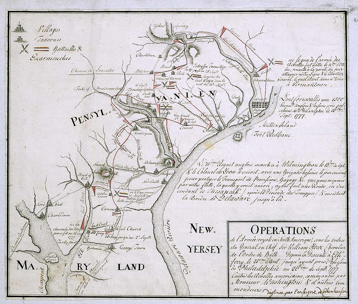
English: 18th century Hessian map from the Marburg State Library in Germany
of the Philadelphia Campaign (Battle of Brandywine, Forts Mercer and Redbank, Germantown, etc.) via the website of the West Jersey History Project http://westjerseyhistory.org/maps/revwarmaps/hessianmaps/index6.shtml Text in French, accompanying maps dated either 1777 or 1787 Quick translation"Operations of the royal army in North America under the orders of Sir William Howe, Knight of the Order of Bath. From the descent at Elk Ferry 25 August until taking possession of Philadelphia 26 September, 1777 against the american Rebels commandeed by Mr. Washington and other commanders. (Map) Designed by Ensign Cochenhausen" |
| منبع | |
| پدیدآور |
اجازهنامه
|
این اثر هنری دوبعدی که در این نگاره دیده میشود بخاطر تاریخ درگذشت پدیدآورنده آن یا تاریخ انتشارش هماکنون در سراسر جهان در مالکیت عمومی قرار دارد و استفاده از آن آزاد است.
بنابراین تکثیر آن در ایالات متحده آمریکا، آلمان و بسیاری کشورهای دیگر آزاد است. {{PD-Art}} template without license parameter: please specify why the underlying work is public domain in both the source country and the United States
(Usage: {{PD-Art|1=|deathyear=''year of author's death''|country=''source country''}}, where parameter 1= can be PD-old-auto, PD-old-auto-expired, PD-old-auto-1996, PD-old-100 or similar. See Commons:Multi-license copyright tags for more information.) | ||||
سیاهه بارگذاری اصلی
- 2008-01-12 16:39 Smallbones 1510×1282×??? (280724 bytes) 18th century Hessian map from the Marburg State Library in Germany of the Philadelphia Campaign (Battle of Brandywine, Forts Mercer and Redbank, Germantown, etc.) via the website of the West Jersey History Project http://westjerseyhistory.org/maps/revwarm
تاریخچهٔ پرونده
روی تاریخ/زمانها کلیک کنید تا نسخهٔ مربوط به آن هنگام را ببینید.
| تاریخ/زمان | بندانگشتی | ابعاد | کاربر | توضیح | |
|---|---|---|---|---|---|
| کنونی | ۲۰ اوت ۲۰۰۸، ساعت ۲۱:۲۳ | | ۱٬۵۱۰ در ۱٬۲۸۲ (۲۷۴ کیلوبایت) | File Upload Bot (Magnus Manske) | {{BotMoveToCommons|en.wikipedia}} {{Information |Description={{en|18th century Hessian map from the Marburg State Library in Germany of the Philadelphia Campaign (Battle of Brandywine, Forts Mercer and Redbank, Germantown, etc.) via the website of the We |
کاربرد پرونده
صفحهٔ زیر از این تصویر استفاده میکند:
کاربرد سراسری پرونده
ویکیهای دیگر زیر از این پرونده استفاده میکنند:
- کاربرد در azb.wikipedia.org
- کاربرد در ca.wikipedia.org
- کاربرد در cs.wikipedia.org
- کاربرد در da.wikipedia.org
- کاربرد در en.wikipedia.org
- کاربرد در es.wikipedia.org
- کاربرد در fi.wikipedia.org
- کاربرد در fr.wikipedia.org
- کاربرد در gl.wikipedia.org
- کاربرد در it.wikipedia.org
- کاربرد در ja.wikipedia.org
- کاربرد در ko.wikipedia.org
- کاربرد در pl.wikipedia.org
- کاربرد در pt.wikipedia.org
- کاربرد در ro.wikipedia.org
- کاربرد در ru.wikipedia.org
- کاربرد در zh.wikipedia.org