پرونده:Sault Ste Marie, Ontario and Michigan.JPG

اندازهٔ این پیشنمایش: ۳۹۸ × ۵۹۹ پیکسل. کیفیتهای دیگر: ۱۵۹ × ۲۴۰ پیکسل | ۳۱۹ × ۴۸۰ پیکسل | ۵۱۰ × ۷۶۸ پیکسل | ۶۸۰ × ۱٬۰۲۴ پیکسل | ۱٬۳۶۰ × ۲٬۰۴۸ پیکسل | ۲٬۸۴۸ × ۴٬۲۸۸ پیکسل.
پروندهٔ اصلی (۲٬۸۴۸ × ۴٬۲۸۸ پیکسل، اندازهٔ پرونده: ۸٫۴۷ مگابایت، نوع MIME پرونده: image/jpeg)
این پرونده در ویکیانبار موجود است. محتویات صفحهٔ توصیف آن در زیر نمایش داده میشود. |
خلاصه
| توضیح |
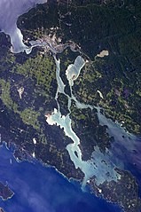
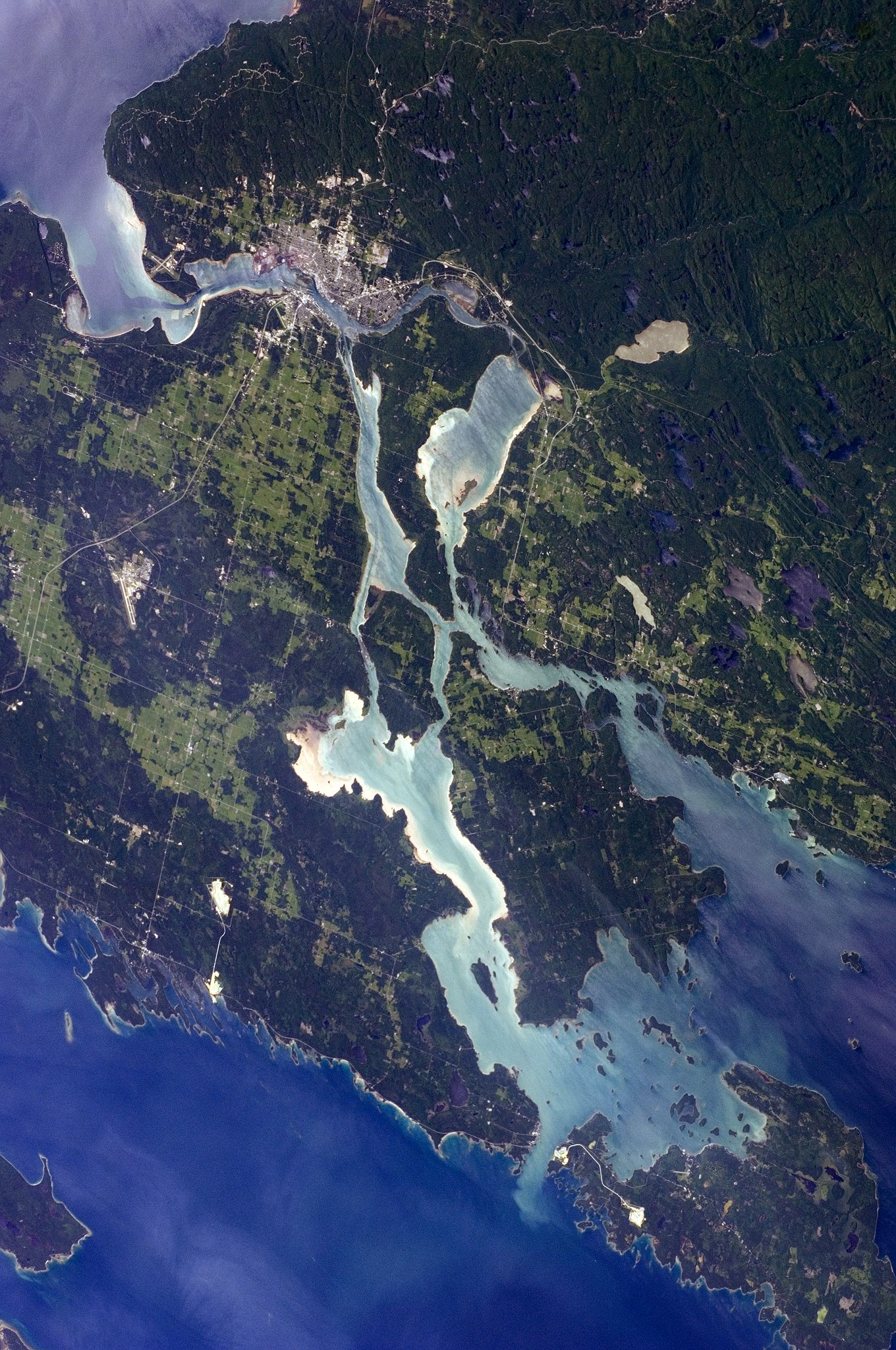
English: The twin cities of Sault Ste Marie are located across the St. Mary’s River, which forms part of the international boundary between Canada (Province of Ontario) and the United States (State of Michigan). This astronaut photograph highlights the two cities, as well as the lakes and islands that separate Lakes Huron and Superior, two of the Great Lakes of North America. Smaller lakes include Lake George to the west, and the large forested islands of St. Joseph and Drummond are visible at image upper left.
The Sault Ste Marie urban areas (image lower left) have a distinctive gray to white colour, contrasting with the deep green of forested areas in Ontario and the lighter green of agricultural fields in Michigan. The water surfaces in the lakes and rivers vary from blue to blue-green to silver, likely the result of varying degrees of sediment and sunglint—light reflecting from the water surface back to the International Space Station. |
| تاریخ | |
| منبع | NASA Earth Observatory |
| پدیدآور | ISS Expedition 28 crew |
| مختصات دوربین | | محل قرارگیری این نگاره و سایر نگارهها در: نقشهٔ شهری باز |
|---|
این نگاره یا ویدیو توسط مرکز فضایی جانسون سازمان ملی هوانوردی و فضایی (NASA)ایالات متحدهٔ آمریکا تحت شناسهٔ عکس: ISS028-E-10162کاتالوگ شدهاست. این برچست وضعیت حق تکثیر اثر ضمیمه شده را مشخص نمیکند. یک برچسپ معمولی همچنان مورد نیاز است. Commons:Licensing را برای کسب اطلاعات مشاهده فرمایید. زبانهای دیگر:
|
Image acquired with a Nikon D2Xs digital camera using a 110 mm lens, and is provided by the ISS Crew Earth Observations experiment and Image Science & Analysis Laboratory, Johnson Space Center.
اجازهنامه
| این پرونده در مالکیت عمومی قرار دارد چرا که توسط ناسا ایجاد شده است. سیاست حق تکثیر ناسا بیان میکند که «مواد ناسا با حق تکثیر محافظت نمیشوند، مگراینکه ذکر شده باشد». (Template:PD-USGov، صفحهٔ سیاست حق تکثیر ناسا یا سیاست جیپیال استفاده از تصاویر را ببینید.) | ||
 |
هشدارها:
|
| برچسبها | این نگاره برچسپگذاری شدهاست: برچسپها را در ویکیانبار مشاهده کنید |
تاریخچهٔ پرونده
روی تاریخ/زمانها کلیک کنید تا نسخهٔ مربوط به آن هنگام را ببینید.
| تاریخ/زمان | بندانگشتی | ابعاد | کاربر | توضیح | |
|---|---|---|---|---|---|
| کنونی | ۱۸ اوت ۲۰۱۸، ساعت ۱۲:۱۲ | | ۲٬۸۴۸ در ۴٬۲۸۸ (۸٫۴۷ مگابایت) | Ras67 | new rendered from NASA's raw image date with real quality and without clipped highlights |
| ۲۳ فوریهٔ ۲۰۱۳، ساعت ۲۰:۴۸ |  | ۲٬۸۴۸ در ۴٬۲۸۸ (۱۲٫۰۳ مگابایت) | Rotatebot | Bot: Image rotated by 90° | |
| ۱۱ ژوئیهٔ ۲۰۱۱، ساعت ۱۲:۲۰ |  | ۴٬۲۸۸ در ۲٬۸۴۸ (۱۰٫۹۲ مگابایت) | Originalwana | {{Information |Description ={{en|1=The twin cities of Sault Ste Marie are located across the St. Mary’s River, which forms part of the international boundary between Canada (Province of Ontario) and the United S |
کاربرد پرونده
صفحهٔ زیر از این تصویر استفاده میکند:
کاربرد سراسری پرونده
ویکیهای دیگر زیر از این پرونده استفاده میکنند:
- کاربرد در ar.wikipedia.org
- کاربرد در el.wikipedia.org
- کاربرد در en.wikipedia.org
- کاربرد در et.wikipedia.org
- کاربرد در fi.wikipedia.org
- کاربرد در it.wikipedia.org
- کاربرد در nl.wikipedia.org