پرونده:US pennsylvanian general USGS.jpg

تفکیکپذیری بالاتری در دسترس نیست.
US_pennsylvanian_general_USGS.jpg (۵۰۰ × ۳۵۳ پیکسل، اندازهٔ پرونده: ۲۲ کیلوبایت، نوع MIME پرونده: image/jpeg)
این پرونده در ویکیانبار موجود است. محتویات صفحهٔ توصیف آن در زیر نمایش داده میشود. |

|
این map نگاره میبایست با استفاده از گرافیک برداری اسویجی فایل بازسازی شوند. این چند مزیت دارد؛ Commons:Media for cleanup را برای اطلاعات بیشتر ببینید. اگر حالت برداری آن در حال حاضر موجود است، لطفاً آن را بار کنید. پس از بارکردن یک اسویجی، این الگو را با {{vector version available|new image name.svg}} جایگزین کنید.
|


خلاصه
| توضیح |
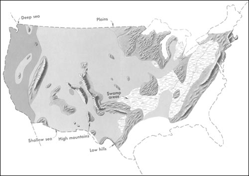
English: Generalized geographic map of the United States location in Middle Pennsylvanian time.
During the Carboniferous period, the contrast in the distribution of land and water from the ancient past to the present becomes more dramatic. The map shows the outline of the United States as it looked during the Pennsylvanian Period some 300 million years ago. It gives the appearance of reversing present-day geography. A highland which lay to the east, south, and north supplied much of the sedimentary debris that was spread over the midwestern part of the United States. The Midwest was mainly a low swampy area in which scouring rushes and fern trees grew in profusion. Sediment was carried into the region from deltas to the east. From time to time, the level of the sea fluctuated -- possibly because of glacial conditions in the Southern Hemisphere. Swamps were flooded, and forests were destroyed. Slowly, layers rich in tree stumps, spores, branches, and leaves were deposited. Later, heat and pressure changed these layers into the coal beds that are so extensive in Illinois, Kentucky, Pennsylvania, West Virginia, and Tennessee. To the west, marine limestones, sandstones, and shales accumulated in shallow seas whose vast expanses were dotted with shoals and islands. Some of the very large islands were formed by the buckling and uplifting of parts of the Earth's crust. |
| تاریخ | توسط ۲۰۰۱ |
| منبع | http://pubs.usgs.gov/gip/continents/pennmap.jpg |
| پدیدآور |
اجازهنامه
این تصویر در مالکیت عمومی است زیرا تنها پدیدآور آن سازمان زمینشناسی آمریکا است که یکی از سازمانهای وابسته به وزارت کشور ایالات متحده آمریکا به شمار میرود. برای اطلاعات بیشتر سیاستهای رسمی حق تکثیر سازمان زمینشناسی آمریکا را ببینید.
|
سیاهه بارگذاری اصلی
صفحهٔ اصلی توضیحات اینجابود. همهٔ نامهای کاربر زیر به en.wikipedia اشاره دارند.
| تاریخ/زمان | ابعاد | کاربر | توضیح |
|---|---|---|---|
| 2005-04-15 02:48 | 500×353× (22509 bytes) | SEWilco | Generalized geographic map of the [[United States]] in [[Middle Pennsylvanian]] time. In the Coal Age, the contrast in the distribution of land and water from the ancient past to the present becomes more dramatic. The map shows the outline of the United |
صفحهٔ اصلی توضیحات اینجابود. همهٔ نامهای کاربر زیر به el.wikipedia اشاره دارند.
| تاریخ/زمان | ابعاد | کاربر | توضیح |
|---|---|---|---|
| 2016-01-16 16:00 | 500×353× (22509 bytes) | Kalogeropoulos | {{Πληροφορίες εικόνας |Περιγραφή=Γενικός γεωγραφικός χάρτης των [[ΗΠΑ]] κατά τη μέση [[Πενσυλβάνια εποχή]] |Πηγή=http://pubs.usgs.gov/gip/continents/pennmap.jpg |Η... |
تاریخچهٔ پرونده
روی تاریخ/زمانها کلیک کنید تا نسخهٔ مربوط به آن هنگام را ببینید.
| تاریخ/زمان | بندانگشتی | ابعاد | کاربر | توضیح | |
|---|---|---|---|---|---|
| کنونی | ۲۲ اکتبر ۲۰۱۶، ساعت ۰۷:۰۴ | | ۵۰۰ در ۳۵۳ (۲۲ کیلوبایت) | MARKELLOS | Transferred from el.wikipedia |
کاربرد پرونده
صفحهٔ زیر از این تصویر استفاده میکند:
کاربرد سراسری پرونده
ویکیهای دیگر زیر از این پرونده استفاده میکنند:
- کاربرد در el.wikipedia.org
- کاربرد در en.wikipedia.org
- کاربرد در zh.wikipedia.org