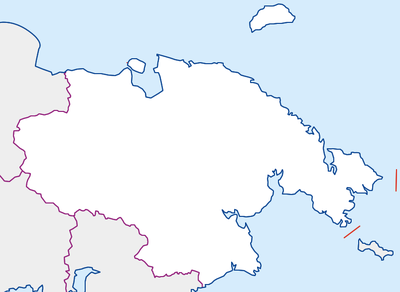
الگو:Location map Russia Chukotka Autonomous Okrug
| نام | Okrug Chukotka خودمختار | |||
|---|---|---|---|---|
| مختصات مرزها | ||||
| 72.76706 | ||||
| 156.69525 | →↕← | -168.170471 | ||
| 61.662832 | ||||
| وسط نقشه | ۶۷°۱۲′۵۴″شمالی ۱۷۴°۱۵′۴۵″شرقی / ۶۷٫۲۱۴۹۴۶°شمالی ۱۷۴٫۲۶۲۳۸۹۵°شرقی | |||
| x | (100*(({{{3}}} + ({{{3}}} < 0)*360) - (156.69525))/((-168.170471 + 360) - (156.69525))) | |||
| y | (100*({{{2}}} - (72.767067))/((61.662832) - (72.767067))) | |||
| تصویر | Chukotka region.png
| |||

| ||||
Template:Location map Russia Chukotka Autonomous Okrug is a location map definition used to overlay markers and labels on an equirectangular projection map of the چوکوتکا in روسیه. It is used by "Template:Location map" when invoked with parameter "Russia Chukotka Autonomous Okrug": {{Location map | Russia Chukotka Autonomous Okrug | ...}}. The markers are placed by عرض جغرافیایی and طول جغرافیایی coordinates on the default map or a similar map image.

| Map parameters | ||
|---|---|---|
| name | Okrug Chukotka خودمختار | name used in default map caption |
| image | Chukotka region.png | file name of map image, without "Image:" or "File:" |
| x | (100*(({{{3}}} + ({{{3}}} < 0)*360) - (156.69525))/((-168.170471 + 360) - (156.69525))) | an expression which evaluates as 0 along the left edge of the map, and 100 along the right edge of the map, where {{{2}}} and {{{3}}} are the degrees latitude and longitude respectively. |
| y | (100*({{{2}}} - (72.767067))/((61.662832) - (72.767067))) | an expression which evaluates as 0 along the top edge of the map, and 100 along the bottom edge of the map, where {{{2}}} and {{{3}}} are the degrees latitude and longitude respectively. |
| top | 72.76706 | top edge of the map in degrees latitude |
| bottom | 61.662832 | bottom edge of the map in degrees latitude |
| left | 156.69525 | left edge of the map in degrees longitude |
| right | -168.170471 | right edge of the map in degrees longitude |
Usage ویرایش
For a description of the parameters, see {{Location map}} and {{Location map many}}.
Location map: Eastern hemisphere, Deg/Min/Sec coordinates ویرایش
{{Location map | Russia Chukotka Autonomous Okrug
| width = 200 | float = right
| caption = Location of [[Anyuysk]] in Chukotka
| label = Anyuysk
| background = lightblue
| position = right
| lat_deg= 68 | lat_min=18 | lat_sec=00 | lat_dir=N
| lon_deg=161 | lon_min=38 | lon_sec=00 | lon_dir=E
}}
Location map: Eastern hemisphere, Decimal coordinates ویرایش
{{Location map | Russia Chukotka Autonomous Okrug
| width = 200 | float = right
| caption = Location of [[Anyuysk]] in Chukotka
| label = Anyuysk
| background = lightblue
| position = right
| lat = 68.3
| long = 161.633
}}
Location map: Western hemisphere, Deg/Min/Sec coordinates ویرایش
{{Location map | Russia Chukotka Autonomous Okrug
| width = 200 | float = right
| caption = Location of [[Uelen]] in Chukotka
| label = Uelen
| background = lightgreen
| position = left
| lat_deg= 66 | lat_min=09 | lat_sec=34 | lat_dir=N
| lon_deg=169 | lon_min=48 | lon_sec=33 | lon_dir=W
}}
Location map: Western hemisphere, Decimal coordinates ویرایش
{{Location map | Russia Chukotka Autonomous Okrug
| width = 200 | float = right
| caption = Location of [[Uelen]] in Chukotka
| label = Uelen
| background = lightgreen
| position = left
| lat = 66.15944
| long = -169.80917
}}
Location map many: Deg/Min/Sec coordinates ویرایش
{{Location map many | Russia Chukotka Autonomous Okrug
| width = 200 | float = right
| caption = [[Anyuysk]] and [[Uelen]] in Chukotka
| label = Anyuysk | label_size = 90
| bg = lightblue | pos = right
| lat_deg= 68 | lat_min=18 | lat_sec=00 | lat_dir=N
| lon_deg=161 | lon_min=38 | lon_sec=00 | lon_dir=E
| label2 = Uelen | label2_size = 90
| bg2 = lightgreen | pos2 = left
| lat2_deg= 66 | lat2_min=09 | lat2_sec=34 | lat2_dir=N
| lon2_deg=169 | lon2_min=48 | lon2_sec=33 | lon2_dir=W
}}
Location map many: Decimal coordinates ویرایش
{{Location map many | Russia Chukotka Autonomous Okrug
| width = 200 | float = right
| caption = [[Anyuysk]] and [[Uelen]] in Chukotka
| label = Anyuysk | label_size = 90
| bg = lightblue | pos = right
| lat = 68.3
| long = 161.633
| label2 = Uelen | label2_size = 90
| bg2 = lightgreen | pos2 = left
| lat2 = 66.15944
| long2 = -169.80917
}}
Technical details ویرایش
For a map using an equirectangular projection which does not cross +/-180 longitude, or +/-90 latitude, the following expressions can be used:
x = 100*(long - left)/(right - left)
y = 100*(lat - top)/(bottom - top)
where lat and long are the degrees latitude and longitude respectively. Here, top and bottom are the degrees latitude of the top and bottom edges of the map, left and right are the degrees latitude of the left and right edges of the map.
Things are a bit more complicated when the map crosses +/-180 longitude, and some sort of "modulo arithmetic" is required. Here, we add 360 if the longitude is less than 0, then use a mapping based on positive coordinates. The following table can be used to check if the expressions are working as desired:
| location | lat | long | (x,y) test | (x,y) exact |
|---|---|---|---|---|
| top/left | 72.76706 | 156.69525 | (0,0) | (0,0) |
| top/right | 72.76706 | -168.170471 | (100,0) | (100,0) |
| bottom/left | 61.662832 | 156.69525 | (0,100) | (0,100) |
| bottom/right | 61.662832 | -168.170471 | (100,100) | (100,100) |
| center | 67.214946 | 174.2623895 | (50,50) | (50,50) |
