پرونده:Alemannic-Dialects-Map-English.png
اندازهٔ این پیشنمایش: ۸۰۰ × ۵۷۱ پیکسل. کیفیتهای دیگر: ۳۲۰ × ۲۲۹ پیکسل | ۶۴۰ × ۴۵۷ پیکسل | ۱٬۰۲۴ × ۷۳۱ پیکسل | ۱٬۴۰۰ × ۱٬۰۰۰ پیکسل.
پروندهٔ اصلی (۱٬۴۰۰ × ۱٬۰۰۰ پیکسل، اندازهٔ پرونده: ۸۳۸ کیلوبایت، نوع MIME پرونده: image/png)
این پرونده در ویکیانبار موجود است. محتویات صفحهٔ توصیف آن در زیر نمایش داده میشود. |
| توضیح |
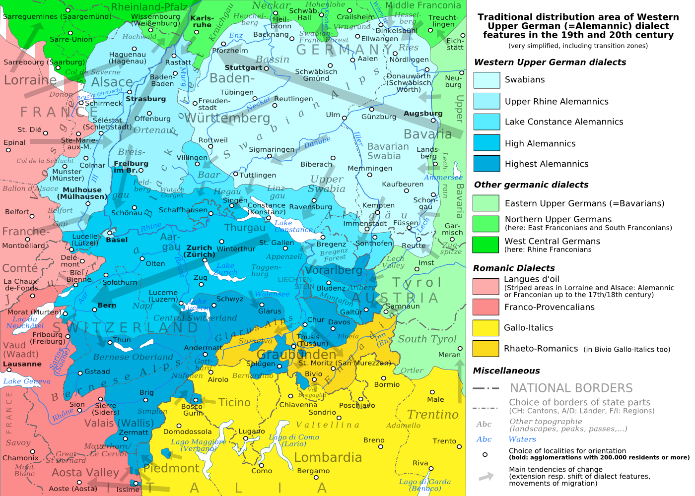
English: The traditional distribution area of the western upper German (=alemannic) dialects in the 19th and 20th century. Source: Mainly these articles in the German wikipedia: * Alemannische Dialekte * Grenzorte des alemannischen Dialektraums * Traditionell rätoromanischsprachiges Gebiet Graubündens and * Sprachen und Dialekte in der Region Elsass, plus the (newer) literature, which is mentioned there. This area, having been quite stable for at least some 300 years up to the 19th century, saw consecutively more or less strong changes by industrialisation, population growth, migrations and political developments. Deutsch: Das traditionelle Verbreitungsgebiet der westoberdeutschen (=alemannischen) Dialekte im 19. und 20. Jahrhundert. Grundlage: vor allem diese Artikel der deutschsprachigen Wikipedia: * Alemannische Dialekte * Grenzorte des alemannischen Dialektraums * Traditionell rätoromanischsprachiges Gebiet Graubündens und * Sprachen und Dialekte in der Region Elsass, sowie die dort jeweils genannte (jüngere) Literatur. Das bis ins 19. Jahrhundert für mindestens etwa 300 Jahre stabile Gebiet erfuhr nachfolgend durch Industrialisierung, Bevölkerungszuwächse und -bewegungen sowie politische Entwicklungen mehr oder weniger starke Änderungen. Français : Le secteur de distribution traditionnel des dialectes allemands supérieurs occidentaux (=alémannique) au 19e et 20e siècle. Source : Principalement ces articles dans le wikipedia allemand : * Alemannische Dialekte * Grenzorte des alemannischen Dialektraums * Traditionell rätoromanischsprachiges Gebiet Graubündens et * Sprachen und Dialekte in der Region Elsass, plus la littérature (plus jeune), qui est mentionnée là. Ce secteur, après avoir été stable jusqu'au 19e siècle pour au moins environ 300 années, scie consécutivement des changements plus ou moins forts par industrialisation, croissance démographique, migrations et développements politiques. Italiano: Area di distribuzione storica delle varianti linguistiche alto-tedesche occidentali(alemanniche) nel diciannovesimo e ventesimo secolo. Fonti: questa mappa si basa prevalentemente sui seguenti articoli in Wikipedia di lingua tedesca: * Alemannische Dialekte * Grenzorte des alemannischen Dialektraums * Traditionell rätoromanischsprachiges Gebiet Graubündens and * Sprachen und Dialekte in der Region Elsass, in aggiunta alla letteratura più recente menzionata in quegli articoli. Questa area, dopo essere rimasta piuttosto stabile per circa trecento anni fino all'inizio del diciannovesimo secolo, ha poi visto trasformazioni di diversa intensità causate dall'industrializzazione, dalla crescita demografica, dai processi migratori e dagli sviluppi politici. |
| تاریخ | (UTC) |
| منبع | |
| پدیدآور |
|
| دیگر نسخهها |
PNG:
PNG:
SVG:
SVG: SVG:
|


| این یک عکس دستکاری شده است به این معنی که به صورت دیجیتالی از نسخهٔ اصلی تغییر یافتهاست. تغییرها: PNG-Version. اصل آن را میتوان در اینجا مشاهده کرد: Alemannic-Dialects-Map-English.svg. تغییرها توسط Testtube انجام شدهاست.
|
من، صاحب حقوق قانونی این اثر، به این وسیله این اثر را تحث اجازهنامههای ذیل منتشر میکنم:
این پرونده با اجازهنامهٔ کریتیو کامانز Attribution-Share Alike 3.0 سازگار نشده، 2.5 عمومی، 2.0 عمومی و 1.0 عمومی منتشر شدهاست.
- شما اجازه دارید:
- برای به اشتراک گذاشتن – برای کپی، توزیع و انتقال اثر
- تلفیق کردن – برای انطباق اثر
- تحت شرایط زیر:
- انتساب – شما باید اعتبار مربوطه را به دست آورید، پیوندی به مجوز ارائه دهید و نشان دهید که آیا تغییرات ایجاد شدهاند یا خیر. شما ممکن است این کار را به هر روش منطقی انجام دهید، اما نه به هر شیوهای که پیشنهاد میکند که مجوزدهنده از شما یا استفادهتان حمایت کند.
- انتشار مشابه – اگر این اثر را تلفیق یا تبدیل میکنید، یا بر پایه آن اثری دیگر خلق میکنید، میبایست مشارکتهای خود را تحت مجوز یکسان یا مشابه با ا اصل آن توزیع کنید.

|
اجازهٔ کپی، پخش و/یا تغییر این سند تحت شرایط مجوز مستندات آزاد گنو، نسخهٔ ۱٫۲ یا هر نسخهٔ بعدتری که توسط بنیاد نرمافزار آزاد منتشر شده؛ بدون بخشهای ناوردا (نامتغیر)، متون روی جلد، و متون پشت جلد، اعطا میشود. یک کپی از مجوز در بخشی تحت عنوان مجوز مستندات آزاد گنو ضمیمه شده است. |
میتوانید مجوز دلخواه خود را برگزینید.
سیاهه بارگذاری اصلی
This image is a derivative work of the following images:
- File:Alemannic-Dialects-Map-English.svg licensed with Cc-by-sa-3.0,2.5,2.0,1.0, GFDL
- 2010-08-11T20:11:45Z Testtube 1400x1000 (482460 Bytes) Bugfix
- 2010-08-11T19:44:48Z Testtube 1400x1000 (482811 Bytes) Bugfix
- 2010-08-11T15:14:04Z Testtube 1400x1000 (482540 Bytes) {{Information |Description={{en|1=The traditional distribution area of the western upper german (=alemannic) dialects in the 19th and 20th century. Source: Mainly these articles in the german wikipedia: * [http://de.wikipedi
Uploaded with derivativeFX
تاریخچهٔ پرونده
روی تاریخ/زمانها کلیک کنید تا نسخهٔ مربوط به آن هنگام را ببینید.
| تاریخ/زمان | بندانگشتی | ابعاد | کاربر | توضیح | |
|---|---|---|---|---|---|
| کنونی | ۱۹ اوت ۲۰۱۰، ساعت ۱۷:۰۱ | | ۱٬۴۰۰ در ۱٬۰۰۰ (۸۳۸ کیلوبایت) | Testtube~commonswiki | Bugfix. |
| ۱۸ اوت ۲۰۱۰، ساعت ۲۰:۱۰ |  | ۱٬۴۰۰ در ۱٬۰۰۰ (۸۳۷ کیلوبایت) | Testtube~commonswiki | {{Information |Description={{en|1=The traditional distribution area of the western upper german (=alemannic) dialects in the 19th and 20th century. Source: Mainly these articles in the german wikipedia: * [http://de.wikipedia.org/wiki/Alemannische_Diale |
کاربرد پرونده
صفحهٔ زیر از این تصویر استفاده میکند:
کاربرد سراسری پرونده
ویکیهای دیگر زیر از این پرونده استفاده میکنند:
- کاربرد در am.wikipedia.org
- کاربرد در ar.wikipedia.org
- کاربرد در azb.wikipedia.org
- کاربرد در be.wikipedia.org
- کاربرد در bg.wikipedia.org
- کاربرد در br.wikipedia.org
- کاربرد در bs.wikipedia.org
- کاربرد در cdo.wikipedia.org
- کاربرد در cs.wikipedia.org
- کاربرد در da.wikipedia.org
- کاربرد در de.wikipedia.org
- کاربرد در el.wikipedia.org
- کاربرد در en.wikipedia.org
- کاربرد در et.wikipedia.org
- کاربرد در fi.wikipedia.org
- کاربرد در gl.wikipedia.org
- کاربرد در he.wikipedia.org
- کاربرد در hr.wikipedia.org
- کاربرد در hu.wikipedia.org
- کاربرد در id.wikipedia.org
- کاربرد در it.wikipedia.org
- کاربرد در ja.wikipedia.org
- کاربرد در ku.wikipedia.org
- کاربرد در lij.wikipedia.org
- کاربرد در lt.wikipedia.org
- کاربرد در lv.wikipedia.org
- کاربرد در mk.wikipedia.org
- کاربرد در nl.wikipedia.org
- کاربرد در no.wikipedia.org
- کاربرد در pl.wikipedia.org
- کاربرد در ru.wikipedia.org
- کاربرد در sat.wikipedia.org
- کاربرد در sh.wikipedia.org
- کاربرد در simple.wikipedia.org
- کاربرد در sl.wikipedia.org
- کاربرد در sq.wikipedia.org
- کاربرد در sv.wikipedia.org
نمایش استفادههای سراسری از این پرونده.