پرونده:Dasht-e Lut Dust Storm Iran TMO 2010023 lrg.jpg

اندازهٔ این پیشنمایش: ۴۵۰ × ۶۰۰ پیکسل. کیفیتهای دیگر: ۱۸۰ × ۲۴۰ پیکسل | ۳۶۰ × ۴۸۰ پیکسل | ۵۷۶ × ۷۶۸ پیکسل | ۷۶۸ × ۱٬۰۲۴ پیکسل | ۲٬۴۰۰ × ۳٬۲۰۰ پیکسل.
پروندهٔ اصلی (۲٬۴۰۰ × ۳٬۲۰۰ پیکسل، اندازهٔ پرونده: ۱٫۳۵ مگابایت، نوع MIME پرونده: image/jpeg)
این پرونده در ویکیانبار موجود است. محتویات صفحهٔ توصیف آن در زیر نمایش داده میشود. |
خلاصه
| توضیح |
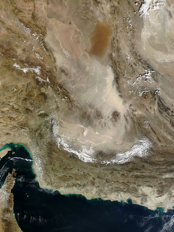
English: Pale tan dust billows over the Dasht-e Lut in eastern Iran, in this photo-like image from the Moderate Resolution Imaging Spectroradiometer (MODIS) on NASA’s Terra satellite. In the thickest part of the storm, the dust cloud blurs the texture of the land beneath it, revealing instead the texture of the air in waves and lines. The most distinctive waves surround Kuh-e Bazman, a 3,489-meter (11,450-foot) tall volcano, which rises above the dust cloud. The ripples in the dust are a reflection of turbulence created as air flows around the peak. The dust seeps into the valleys of the mountains south and east of the volcano.
The Dasht-e Lut, is a large salt desert in remote eastern Iran. The dust storm blows across the southern desert, leaving clear the distinctive orange dune fields and wind-swept lines in the north. |
| تاریخ | |
| منبع | http://earthobservatory.nasa.gov/NaturalHazards/view.php?id=42443&src=nha |
| پدیدآور | NASA |
== Assessment ==
|
اجازهنامه
| این پرونده در مالکیت عمومی قرار دارد چرا که توسط ناسا ایجاد شده است. سیاست حق تکثیر ناسا بیان میکند که «مواد ناسا با حق تکثیر محافظت نمیشوند، مگراینکه ذکر شده باشد». (Template:PD-USGov، صفحهٔ سیاست حق تکثیر ناسا یا سیاست جیپیال استفاده از تصاویر را ببینید.) | ||
 |
هشدارها:
|
تاریخچهٔ پرونده
روی تاریخ/زمانها کلیک کنید تا نسخهٔ مربوط به آن هنگام را ببینید.
| تاریخ/زمان | بندانگشتی | ابعاد | کاربر | توضیح | |
|---|---|---|---|---|---|
| کنونی | ۲۷ ژانویهٔ ۲۰۱۰، ساعت ۱۹:۳۲ | | ۲٬۴۰۰ در ۳٬۲۰۰ (۱٫۳۵ مگابایت) | Captain-tucker | {{Information |Description={{en|Pale tan dust billows over the Dasht-e Lut in eastern Iran, in this photo-like image from the Moderate Resolution Imaging Spectroradiometer (MODIS) on NASA’s Terra satellite. In the thickest part of the storm, the dust cl |
کاربرد پرونده
صفحههای زیر از این تصویر استفاده میکنند:
- تصویربرداری ماهوارهای
- دریای عمان
- دشت لوت
- بحث:دشت لوت
- ویکیپدیا:آیا میدانستید که...؟/هفتههای ۲۰۱۷ (میلادی)
- ویکیپدیا:آیا میدانستید که...؟/۲۰۱۷/هفته ۰۳
- ویکیپدیا:نگاره روز/ژوئن ۲۰۱۶
- ویکیپدیا:نگارههای برگزیده/نگاه به زمین
- ویکیپدیا:گزیدن نگاره برگزیده/Dasht-e Lut Dust Storm Iran TMO 2010023 lrg.jpg
- بحث ویکیپدیا:آیا میدانستید که...؟/۲۰۱۷/هفته ۰۳
- الگو:نر/2016-06-22
- الگو:نر محافظت شده/2016-06-22
کاربرد سراسری پرونده
ویکیهای دیگر زیر از این پرونده استفاده میکنند:
- کاربرد در af.wikipedia.org
- کاربرد در ckb.wikipedia.org
- کاربرد در cs.wikipedia.org
- کاربرد در he.wikipedia.org
- کاربرد در mn.wikipedia.org
- کاربرد در sk.wikipedia.org