پرونده:Delian League Campaign Map.png
تفکیکپذیری بالاتری در دسترس نیست.
Delian_League_Campaign_Map.png (۵۰۰ × ۵۰۰ پیکسل، اندازهٔ پرونده: ۵۲۶ کیلوبایت، نوع MIME پرونده: image/png)
این پرونده در ویکیانبار موجود است. محتویات صفحهٔ توصیف آن در زیر نمایش داده میشود. |
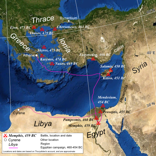
| توضیح | Map of the eastern Mediterranean, showing the location of battles fought by the Delian League, 477–450 BC |
| تاریخ | (UTC) |
| منبع | |
| پدیدآور |
|
| دیگر نسخهها | آثار انشقاقی از این پرونده: Mapa de campanya de la Lliga de Delos.jpg |
| این یک عکس دستکاری شده است به این معنی که به صورت دیجیتالی از نسخهٔ اصلی تغییر یافتهاست. اصل آن را میتوان در اینجا مشاهده کرد: Mediterranean Sea political map-blank.svg.
|
| این تصویر در مالکیت عمومی قرار دارد به این دلیل که از نرمافزار زمین ناسا World Wind با استفاده یک لایهٔ مالکیت عمومی، از قبیل Blue Marble، MODIS، Landsat، SRTM، USGS یا GLOBE گرفته شده است.
|
 |
| This work was previously under Public Domain, or a Free License. It has been digitally enhanced and/or modified. This derivative work has been (or is hereby) released into the public domain by its author, [[:{{{1}}}:User:{{{3}}}|{{{3}}}]] at the [[:{{{1}}}:|{{{2}}}]] project. This applies worldwide. In some countries this is not legally possible; if so:
|
سیاهه بارگذاری اصلی
This image is a derivative work of the following images:
- File:Mediterranean_Sea_political_map-blank.svg licensed with PD-WorldWind, PD-retouched-user-w
- 2008-05-19T16:14:51Z Sting 2046x1496 (1109412 Bytes) "Tropic of Cancer" label correction
- 2007-06-21T01:07:02Z Sting 2046x1496 (1109639 Bytes) {{Information |Description=Blank map of the [[:en:Mediterranean Sea|Mediterranean Sea]], with the State borders. |Source=Own work ;Background map : screenshot from NASA World Wind (Public Domain) |Date=June 2007 |Author=Eric
Uploaded with derivativeFX
تاریخچهٔ پرونده
روی تاریخ/زمانها کلیک کنید تا نسخهٔ مربوط به آن هنگام را ببینید.
| تاریخ/زمان | بندانگشتی | ابعاد | کاربر | توضیح | |
|---|---|---|---|---|---|
| کنونی | ۲۲ ژوئیهٔ ۲۰۰۹، ساعت ۲۰:۳۹ | | ۵۰۰ در ۵۰۰ (۵۲۶ کیلوبایت) | MinisterForBadTimes | Some rearrangements |
| ۲۲ ژوئیهٔ ۲۰۰۹، ساعت ۲۰:۳۰ |  | ۵۰۰ در ۵۰۰ (۵۲۵ کیلوبایت) | MinisterForBadTimes | Re-sized and shaped | |
| ۲۹ ژوئن ۲۰۰۹، ساعت ۰۶:۵۶ |  | ۱٬۰۰۰ در ۷۳۱ (۱٫۲۷ مگابایت) | MinisterForBadTimes | {{Information |Description=Map of the eastern Mediterranean, showing the location of battles fought by the Delian League, 477–450 BC |Source=*File:Mediterranean_Sea_political_map-blank.svg |Date=2009-06-29 07:51 (UTC) |Author=*[[:File:Mediterr |
کاربرد پرونده
صفحهٔ زیر از این تصویر استفاده میکند:
کاربرد سراسری پرونده
ویکیهای دیگر زیر از این پرونده استفاده میکنند:
- کاربرد در af.wikipedia.org
- کاربرد در azb.wikipedia.org
- کاربرد در ca.wikipedia.org
- کاربرد در el.wikipedia.org
- کاربرد در en.wikipedia.org
- کاربرد در es.wikipedia.org
- کاربرد در eu.wikipedia.org
- کاربرد در hr.wikipedia.org
- کاربرد در hu.wikipedia.org
- کاربرد در id.wikipedia.org
- کاربرد در it.wikipedia.org
- کاربرد در it.wikiversity.org
- کاربرد در pl.wikipedia.org
- کاربرد در pnb.wikipedia.org
- کاربرد در pt.wikipedia.org
- کاربرد در ru.wikipedia.org
- کاربرد در sh.wikipedia.org
- کاربرد در ta.wikipedia.org
- کاربرد در ur.wikipedia.org