پرونده:Fire Island-NY-USA-Location Map-01.svg

حجم پیشنمایش PNG این SVG file:۶۷۰ × ۲۹۹ پیکسل کیفیتهای دیگر: ۳۲۰ × ۱۴۳ پیکسل | ۶۴۰ × ۲۸۶ پیکسل | ۱٬۰۲۴ × ۴۵۷ پیکسل | ۱٬۲۸۰ × ۵۷۱ پیکسل | ۲٬۵۶۰ × ۱٬۱۴۲ پیکسل.
پروندهٔ اصلی (پروندهٔ اسویجی، با ابعاد ۶۷۰ × ۲۹۹ پیکسل، اندازهٔ پرونده: ۲۱۵ کیلوبایت)
این پرونده در ویکیانبار موجود است. محتویات صفحهٔ توصیف آن در زیر نمایش داده میشود. |
خلاصه
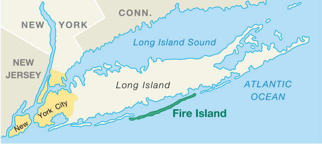
| توضیح | Fire Island, New York, US, Location Map |
| تاریخ | created/published 2006-03-07 |
| منبع | National Park Service, Area Map, converted from PDF file, modified |
| پدیدآور | U.S. Department of Interior, National Park Service |
| دیگر نسخهها |
|

اجازهنامه
| This image or media file contains material based on a work of a National Park Service employee, created as part of that person's official duties. As a work of the U.S. federal government, such work is in the public domain in the United States. See the NPS website and NPS copyright policy for more information. |
تاریخچهٔ پرونده
روی تاریخ/زمانها کلیک کنید تا نسخهٔ مربوط به آن هنگام را ببینید.
| تاریخ/زمان | بندانگشتی | ابعاد | کاربر | توضیح | |
|---|---|---|---|---|---|
| کنونی | ۲۷ اکتبر ۲۰۱۷، ساعت ۱۲:۴۲ | | ۶۷۰ در ۲۹۹ (۲۱۵ کیلوبایت) | Opencooper | == {{int:filedesc}} == {{Information |Description = Fire Island, New York, US, Location Map |Source = [http://www.nps.gov/fiis/pphtml/maps.html National Park Service], [https://web.archive.org/web/20041027185131/http://data2.itc.nps.gov:80/parks/fiis/p... |
کاربرد پرونده
صفحهٔ زیر از این تصویر استفاده میکند:
کاربرد سراسری پرونده
ویکیهای دیگر زیر از این پرونده استفاده میکنند:
- کاربرد در ca.wikipedia.org
- کاربرد در de.wikipedia.org
- کاربرد در en.wikipedia.org
- کاربرد در en.wiktionary.org
- کاربرد در es.wikipedia.org
- کاربرد در et.wikipedia.org
- کاربرد در fi.wikipedia.org
- کاربرد در fr.wikipedia.org
- کاربرد در it.wikipedia.org
- کاربرد در ko.wikipedia.org
- کاربرد در no.wikipedia.org
- کاربرد در pl.wikipedia.org
- کاربرد در pt.wikipedia.org
- کاربرد در simple.wikipedia.org
- کاربرد در sv.wikipedia.org
- کاربرد در tr.wikipedia.org
- کاربرد در zh.wikipedia.org