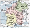
پرونده:Francia at the death of Pepin of Heristal, 714.jpg

پروندهٔ اصلی(۱٬۲۵۴ × ۱٬۱۴۹ پیکسل، اندازهٔ پرونده: ۱ مگابایت، نوع MIME پرونده: image/jpeg)

خلاصه

توضیح
English: Francia at the death of Pepin of Heristal, 714
Français : Gaule à l'avènement de Charles Martel (714).
تاریخ
منبع Paul Vidal de la Blache's Atlas général d'histoire et de géographie (1912). The original scanned image can be found at http://www.hipkiss.org/data/maps/vidal-lablache_atlas-general-histoire-et-geographie_1912_ancient-gaul-merovian-merovingienne_2953_4252_600.jpg. Information on the original scan can be found at http://www.hipkiss.org/cgi-bin/maps.pl?book=Vidal%20Lablache%20-%20Atlas%20General%20Histoire%20Et%20Geographie.
پدیدآور
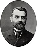
ویدال دولابلاش  (1845–1918)  wikidata:Q311865 s:fr:Auteur:Paul Vidal de La Blache q:fr:Paul Vidal de La Blache
 
ویدال دولابلاش
نام‌های دیگر
Paul Vidal de la Blanche
توضیحات جغرافی‌دان و نقشه‌نگار فرانسوی
تاریخ تولد/درگذشت ‏۲۲ ژانویهٔ ۱۸۴۵‏ ویرایش در ویکی‌داده ‏۵ آوریل ۱۹۱۸‏ ویرایش در ویکی‌داده
محل تولد/مرگ Pézenas لسن سور مر
کنترل از طریق مرجع
creator QS:P170,Q311865
دیگر نسخه‌ها
File:Francia at the death of Pepin of Heristal 714-es.svg یک نسخهٔ برداری از این پرونده است.
آن پرونده را هنگامی که بهتر بود می‌بایست به جای این نسخهٔ تصویر استفاده کرد.

File:Francia at the death of Pepin of Heristal, 714.jpg → File:Francia at the death of Pepin of Heristal 714-es.svg

برای کسب اطلاعات بیشتر در ارتباط با تصاویر برداری لطفاً اینجا را مطالعه‌کنید.
همچنین اطلاعات بیشتری در ارتباط با حمایت مدیاویکی از تصاویر اس‌وی‌جی وجود دارد.

در زبان های دیگر
Alemannisch  Bahasa Indonesia  Bahasa Melayu  British English  català  čeština  dansk  Deutsch  eesti  English  español  Esperanto  euskara  français  Frysk  galego  hrvatski  Ido  italiano  lietuvių  magyar  Nederlands  norsk bokmål  norsk nynorsk  occitan  Plattdüütsch  polski  português  português do Brasil  română  Scots  sicilianu  slovenčina  slovenščina  suomi  svenska  Tiếng Việt  Türkçe  vèneto  Ελληνικά  беларуская (тарашкевіца)  български  македонски  нохчийн  русский  српски / srpski  татарча/tatarça  українська  ქართული  հայերեն  বাংলা  தமிழ்  മലയാളം  ไทย  한국어  日本語  简体中文  繁體中文  עברית  العربية  فارسی  +/−
New SVG image

اجازه‌نامه

This image is in the public domain because it is a mere mechanical scan or photocopy of a public domain original, or – from the available evidence – is so similar to such a scan or photocopy that no copyright protection can be expected to arise. The original itself is in the public domain for the following reason:
Public domain

پدیدآورنده این اثر در سال 1918 درگذشته است، پس این اثر در کشورهایی و مناطقی که مدت زمان حق تکثیر، عمر پدیدآورنده بعلاوه 100 سال یا کمتر بعد از مرگ او است، در مالکیت عمومی قرار دارد.


این اثر در ایالات متحده آمریکا در مالکیت عمومی قرار دارد به این دلیل که قبل از ۱ ژانویهٔ ۱۹۲۹ منتشر یا در ادارهٔ حق تکثیر آمریکا ثبت شده‌است.


This tag is designed for use where there may be a need to assert that any enhancements (eg brightness, contrast, colour-matching, sharpening) are in themselves insufficiently creative to generate a new copyright. It can be used where it is unknown whether any enhancements have been made, as well as when the enhancements are clear but insufficient. For known raw unenhanced scans you can use an appropriate {{PD-old}} tag instead. For usage, see Commons:When to use the PD-scan tag.


Note: This tag applies to scans and photocopies only. For photographs of public domain originals taken from afar, {{PD-Art}} may be applicable. See Commons:When to use the PD-Art tag.

سیاهه بارگذاری اصلی

The original description page is/was here. All following user names refer to en.wikipedia.

  • 2007-08-19 21:33 Srnec 1241×1136×8 (353954 bytes) The map comes from Vidal-Lablache, ''Atlas général d'histoire et de géographie'' (1894). {{PD-art-life-70}}
  • 2007-09-10 16:34 Earthsound 1254 × 1149×8 (1 MB) Gaule at the time of Charles Martel (714). The scale is 1:12,000,000 This is a straightened and color balanced crop of a scan of a map from Paul Vidal de la Blache's 'Atlas général d'histoire et de géograp. {{PD-art-life-70}}

عنوان

شرحی یک‌خطی از محتوای این فایل اضافه کنید

آیتم‌هایی که در این پرونده نمایش داده شده‌اند

توصیف‌ها

تاریخچهٔ پرونده

روی تاریخ/زمان‌ها کلیک کنید تا نسخهٔ مربوط به آن هنگام را ببینید.

تاریخ/زمانبندانگشتیابعادکاربرتوضیح
کنونی‏۲۱ سپتامبر ۲۰۱۹، ساعت ۱۴:۲۶تصویر بندانگشتی از نسخهٔ مورخ ‏۲۱ سپتامبر ۲۰۱۹، ساعت ۱۴:۲۶۱٬۲۵۴ در ۱٬۱۴۹ (۱ مگابایت)OgreBot(BOT): Reverting to most recent version before archival
‏۲۱ سپتامبر ۲۰۱۹، ساعت ۱۴:۲۶تصویر بندانگشتی از نسخهٔ مورخ ‏۲۱ سپتامبر ۲۰۱۹، ساعت ۱۴:۲۶۱٬۲۴۱ در ۱٬۱۴۸ (۳۴۹ کیلوبایت)OgreBot(BOT): Uploading old version of file from en.wikipedia; originally uploaded on 2007-08-19 21:41:17 by Srnec
‏۲۲ ژانویهٔ ۲۰۰۸، ساعت ۱۹:۲۳تصویر بندانگشتی از نسخهٔ مورخ ‏۲۲ ژانویهٔ ۲۰۰۸، ساعت ۱۹:۲۳۱٬۲۵۴ در ۱٬۱۴۹ (۱ مگابایت)Vladimir Solovjev{{Information |Description={{en|This is a straightened and color balanced crop of a scan of a map from Paul Vidal de la Blache's ''Atlas général d'histoire et de géographie'' (1912).}} |Source=Transfered from [http://en.wikipedia.org

صفحهٔ زیر از این تصویر استفاده می‌کند:

کاربرد سراسری پرونده

ویکی‌های دیگر زیر از این پرونده استفاده می‌کنند:

نمایش استفاده‌های سراسری از این پرونده.