پرونده:Gulf Stream water temperature.jpg
تفکیکپذیری بالاتری در دسترس نیست.
Gulf_Stream_water_temperature.jpg (۵۳۸ × ۵۶۶ پیکسل، اندازهٔ پرونده: ۴۳۸ کیلوبایت، نوع MIME پرونده: image/jpeg)
این پرونده در ویکیانبار موجود است. محتویات صفحهٔ توصیف آن در زیر نمایش داده میشود. |
خلاصه
| توضیح |
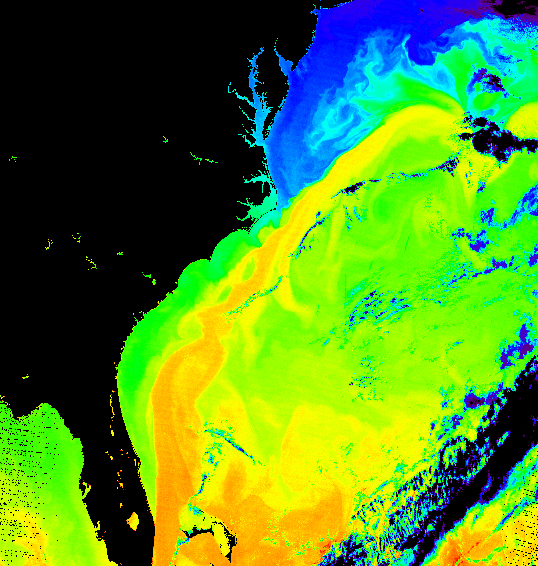
Español: Temperatura del agua en la Corriente del Golfo.
English: False-color image of the temperature of the Gulf Stream
|
| تاریخ | |
| منبع | |
| پدیدآور | Donna Thomas/MODIS Ocean Group NASA/GSFC SST product by R. Evans et al., U. Miami |
اجازهنامه
| این پرونده در مالکیت عمومی قرار دارد چرا که توسط ناسا ایجاد شده است. سیاست حق تکثیر ناسا بیان میکند که «مواد ناسا با حق تکثیر محافظت نمیشوند، مگراینکه ذکر شده باشد». (Template:PD-USGov، صفحهٔ سیاست حق تکثیر ناسا یا سیاست جیپیال استفاده از تصاویر را ببینید.) | ||
 |
هشدارها:
|
تاریخچهٔ پرونده
روی تاریخ/زمانها کلیک کنید تا نسخهٔ مربوط به آن هنگام را ببینید.
| تاریخ/زمان | بندانگشتی | ابعاد | کاربر | توضیح | |
|---|---|---|---|---|---|
| کنونی | ۱۷ آوریل ۲۰۰۵، ساعت ۱۶:۵۳ | | ۵۳۸ در ۵۶۶ (۴۳۸ کیلوبایت) | Mschlindwein | False-color image of the temperature of the Gulf Stream |
کاربرد پرونده
صفحهٔ زیر از این تصویر استفاده میکند:
کاربرد سراسری پرونده
ویکیهای دیگر زیر از این پرونده استفاده میکنند:
- کاربرد در ast.wikipedia.org
- کاربرد در az.wikipedia.org
- کاربرد در ba.wikipedia.org
- کاربرد در be.wikipedia.org
- کاربرد در bg.wikipedia.org
- کاربرد در cs.wikipedia.org
- کاربرد در cv.wikipedia.org
- کاربرد در da.wikipedia.org
- کاربرد در el.wikipedia.org
- کاربرد در en.wikipedia.org
- کاربرد در en.wikibooks.org
- کاربرد در es.wikipedia.org
- کاربرد در fi.wikipedia.org
- کاربرد در fi.wikibooks.org
- کاربرد در fr.wikipedia.org
- کاربرد در gl.wikipedia.org
- کاربرد در he.wikipedia.org
- کاربرد در hu.wikipedia.org
- کاربرد در is.wikipedia.org
- کاربرد در it.wikipedia.org
- کاربرد در ko.wikipedia.org
- کاربرد در nl.wikipedia.org
- کاربرد در nn.wikipedia.org
- کاربرد در no.wikipedia.org
- کاربرد در oc.wikipedia.org
- کاربرد در pt.wikipedia.org
- کاربرد در ru.wikipedia.org
- کاربرد در sah.wikipedia.org
- کاربرد در sh.wikipedia.org
- کاربرد در sk.wikipedia.org
- کاربرد در sq.wikipedia.org
- کاربرد در sr.wikipedia.org
- کاربرد در tr.wikipedia.org
- کاربرد در uk.wikipedia.org
- کاربرد در vls.wikipedia.org
نمایش استفادههای سراسری از این پرونده.