پرونده:Hilo after Tsunami 1960.jpg
اندازهٔ این پیشنمایش: ۷۵۶ × ۶۰۰ پیکسل. کیفیتهای دیگر: ۳۰۳ × ۲۴۰ پیکسل | ۶۰۵ × ۴۸۰ پیکسل | ۸۳۸ × ۶۶۵ پیکسل.
پروندهٔ اصلی (۸۳۸ × ۶۶۵ پیکسل، اندازهٔ پرونده: ۱۸۵ کیلوبایت، نوع MIME پرونده: image/jpeg)
این پرونده در ویکیانبار موجود است. محتویات صفحهٔ توصیف آن در زیر نمایش داده میشود. |
خلاصه
| توضیح |
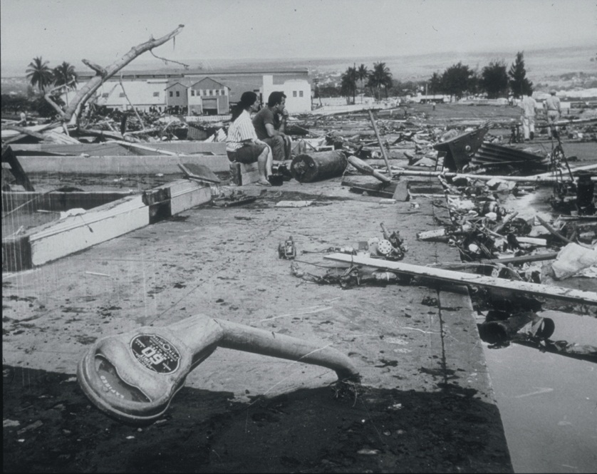
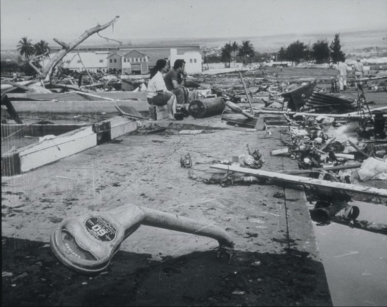
English: Tsunami Generated by Earthquake of May 22, 1960, Coast of Chile
The Waiakea area of Hilo, Hawaii, 10,000 km from the generating area. Parking meters were bent by the force of the debris-filled waves. Note the scattered debris and the gutted foundation. This tsunami, generated by the earthquake off the coast of central Chile, affected the entire Pacific Basin. One of the most seriously affected areas was Hilo, Hawaii, where 61 deaths and $24 million in damage occurred. In the area of maximum destruction, only buildings of reinforced concrete or structural steel, and a few others sheltered by these buildings, remained standing -- and even these were generally gutted. Frame buildings either were crushed or floated early to the limits of flooding. Photo credit: U.S. Navy |
| تاریخ | |
| منبع | http://www.ngdc.noaa.gov/nndc/struts/results?EQ_0=4227&t=101634&s=80&d=80 |
| پدیدآور | US Navy |
اجازهنامه
این پرونده اثر یک دریانورد یا کارمند نیروی دریایی ایالات متحده که طی انجام مأموریتهای رسمی شخص گرفته شدهاست. به عنوان اثری از دولت فدرال ایالات متحده، نگاره در مالکیت عمومی قرار دارد.
|
 | |
| این پرونده تحت قانون حق تکثیر محدودیت آزاد منتشر شده که شامل تمامی حقوق مربوطه و حقوق نزدیک به آن میشود. | ||
تاریخچهٔ پرونده
روی تاریخ/زمانها کلیک کنید تا نسخهٔ مربوط به آن هنگام را ببینید.
| تاریخ/زمان | بندانگشتی | ابعاد | کاربر | توضیح | |
|---|---|---|---|---|---|
| کنونی | ۲۱ مارس ۲۰۱۰، ساعت ۲۱:۰۶ | | ۸۳۸ در ۶۶۵ (۱۸۵ کیلوبایت) | Q-ß | {{Information |Description={{en|1=Tsunami Generated by Earthquake of May 22, 1960, Coast of Chile The Waiakea area of Hilo, Hawaii, 10,000 km from the generating area. Parking meters were bent by the force of the debris-filled waves. Note the scattered de |
کاربرد پرونده
صفحهٔ زیر از این تصویر استفاده میکند:
کاربرد سراسری پرونده
ویکیهای دیگر زیر از این پرونده استفاده میکنند:
- کاربرد در ckb.wikipedia.org
- کاربرد در de.wikipedia.org
- کاربرد در el.wikipedia.org
- کاربرد در en.wikipedia.org
- کاربرد در es.wikipedia.org
- کاربرد در fy.wikipedia.org
- کاربرد در id.wikipedia.org
- کاربرد در ja.wikipedia.org
- کاربرد در ko.wikipedia.org
- کاربرد در nl.wikipedia.org
- کاربرد در pl.wikipedia.org
- کاربرد در pt.wikipedia.org