پرونده:Kashmir Region (2020 skirmish locations).jpg
اندازهٔ این پیشنمایش: ۶۰۴ × ۵۹۹ پیکسل. کیفیتهای دیگر: ۲۴۲ × ۲۴۰ پیکسل | ۴۸۴ × ۴۸۰ پیکسل | ۷۷۴ × ۷۶۸ پیکسل | ۱٬۰۳۳ × ۱٬۰۲۴ پیکسل | ۱٬۵۷۹ × ۱٬۵۶۶ پیکسل.
پروندهٔ اصلی (۱٬۵۷۹ × ۱٬۵۶۶ پیکسل، اندازهٔ پرونده: ۱٫۲۷ مگابایت، نوع MIME پرونده: image/jpeg)
این پرونده در ویکیانبار موجود است. محتویات صفحهٔ توصیف آن در زیر نمایش داده میشود. |
.jpg?uselang=fa)
خلاصه
| توضیح |
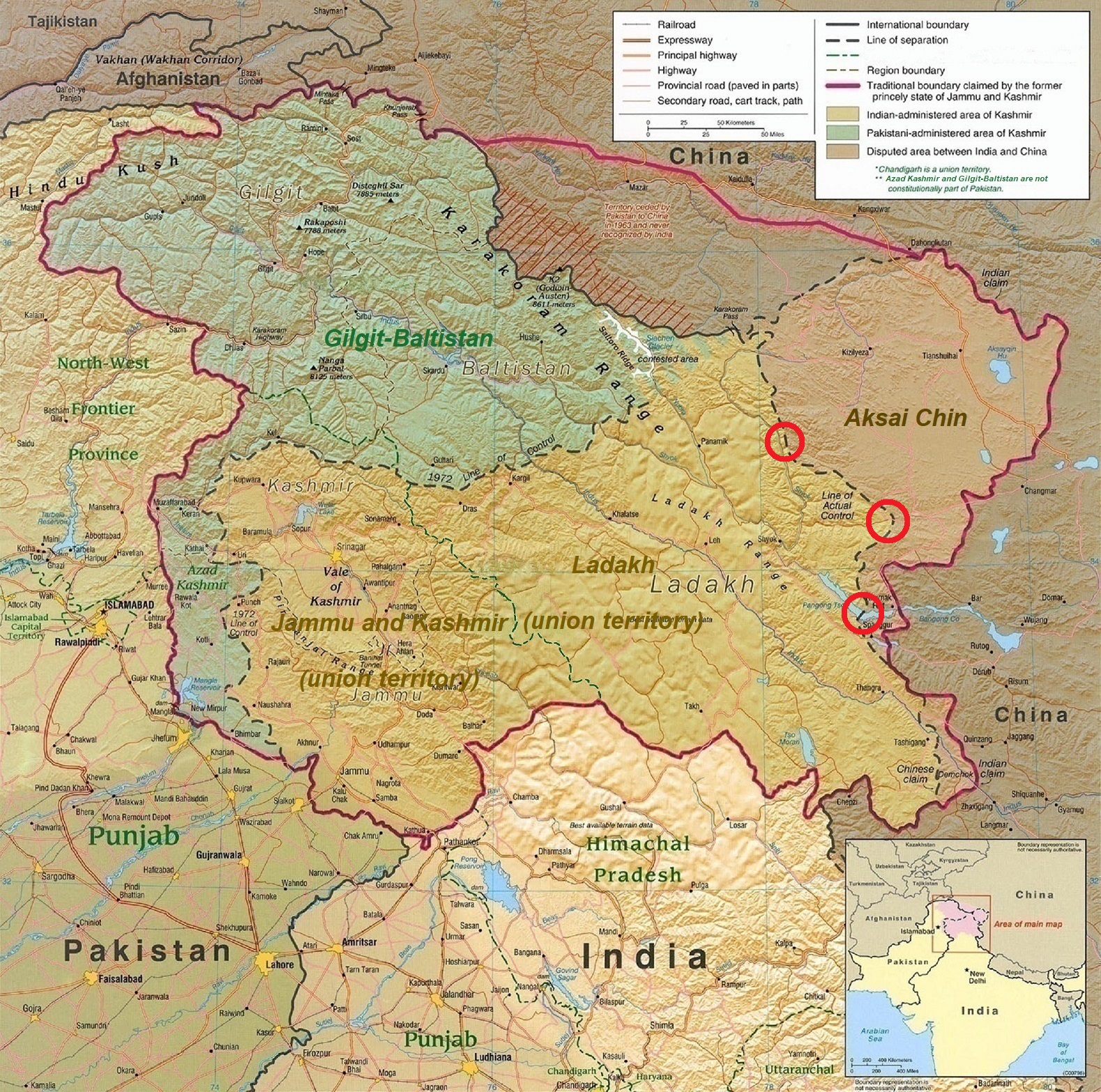
English: A map of the disputed Kashmir region created by the United States CIA in 2004 and hosted by the University of Texas at Austin Perry-Castañeda Library Map Collection; altered to show new jurisdictions by Fowler&fowler in November 2019; altered by to show 2020 skirmish locations by MarkH21 in June 2020. The red circles mark the rough locations of the conflicts at the the Galwan Valley (top), Hot Springs, Chang Chenmo Valley checkpoint (middle), and Pangong Tso (near the bottom). |
| تاریخ | |
| منبع | Map of Kashmir region created by the US Central Intelligence Agency, 2004 |
| پدیدآور | United States Central Intelligence Agency |
| دیگر نسخهها |
  |
اجازهنامه
این اثر در مالکیت عمومی در ایالات متحده قرار دارد به این دلیل که اثر از دولت فدرال ایالات متحده تحت شرایط Title 17, Chapter 1, Section 105 of the US Code قرار دارد. حق تکثیر را ببینید.
توجه: این فقط برای آثاری که دولت فدرال ایجاد کرده صدق میکند و نه هر کار شخصی در ایالتهای ایالات متحده، قلمروها، اجتماعها، شهرستان، شهردار، یا هر تقسیم بندی دیگری. این الگو همچنین در رابطه با تمبرهای پستی طراحی و منتشر شده توسط خدمات پستی ایالات متحده از ۱۹۸۷ صدق نمیکند. (206.02(b) of Compendium II: Copyright Office Practices را ببینید). این همچنین در رابطه با سکههای ایالات متحده صدق نمیکند، The US Mint Terms of Use. را ببینید.
|
 | |
| این پرونده تحت قانون حق تکثیر محدودیت آزاد منتشر شده که شامل تمامی حقوق مربوطه و حقوق نزدیک به آن میشود. | ||
| برچسبها | این نگاره برچسپگذاری شدهاست: برچسپها را در ویکیانبار مشاهده کنید |
.jpg)
تاریخچهٔ پرونده
روی تاریخ/زمانها کلیک کنید تا نسخهٔ مربوط به آن هنگام را ببینید.
| تاریخ/زمان | بندانگشتی | ابعاد | کاربر | توضیح | |
|---|---|---|---|---|---|
| کنونی | ۲۴ ژوئن ۲۰۲۰، ساعت ۱۸:۴۵ | | ۱٬۵۷۹ در ۱٬۵۶۶ (۱٫۲۷ مگابایت) | MarkH21 | Removed the Daulat Beg Oldi circle as not being an actual location of conflict; added the Hot Springs, Chang Chenmo Valley circle as an actual location of conflict. |
| ۲۴ ژوئن ۲۰۲۰، ساعت ۰۲:۰۱ |  | ۱٬۵۷۹ در ۱٬۵۶۶ (۱٫۲۷ مگابایت) | MarkH21 | Uploaded a work by United States Central Intelligence Agency, MarkH21 from [https://legacy.lib.utexas.edu/maps/middle_east_and_asia/kashmir_region_2004.jpg Map of Kashmir region] created by the US Central Intelligence Agency, 2004; altered by MarkH21 with UploadWizard |
کاربرد پرونده
صفحهٔ زیر از این تصویر استفاده میکند:
کاربرد سراسری پرونده
ویکیهای دیگر زیر از این پرونده استفاده میکنند:
- کاربرد در af.wikipedia.org
- کاربرد در ca.wikipedia.org
- کاربرد در en.wikipedia.org
- کاربرد در es.wikipedia.org
- کاربرد در fr.wikipedia.org
- کاربرد در he.wikipedia.org
- کاربرد در ja.wikipedia.org
- کاربرد در ka.wikipedia.org
- کاربرد در ml.wikipedia.org
- کاربرد در ne.wikipedia.org
- کاربرد در pnb.wikipedia.org
- کاربرد در pt.wikipedia.org
- کاربرد در ru.wikipedia.org
- کاربرد در simple.wikipedia.org
- کاربرد در so.wikipedia.org
- کاربرد در ta.wikipedia.org
- کاربرد در te.wikipedia.org
- کاربرد در th.wikipedia.org
- کاربرد در tr.wikipedia.org
- کاربرد در uk.wikipedia.org
- کاربرد در ur.wikipedia.org
- کاربرد در vi.wikipedia.org
- کاربرد در www.wikidata.org
- کاربرد در zh.wikipedia.org
.jpg)