پرونده:Kingdom of Arles 1000.svg

حجم پیشنمایش PNG این SVG file:۴۸۵ × ۳۴۰ پیکسل کیفیتهای دیگر: ۳۲۰ × ۲۲۴ پیکسل | ۶۴۰ × ۴۴۹ پیکسل | ۱٬۰۲۴ × ۷۱۸ پیکسل | ۱٬۲۸۰ × ۸۹۷ پیکسل | ۲٬۵۶۰ × ۱٬۷۹۵ پیکسل.
پروندهٔ اصلی (پروندهٔ اسویجی، با ابعاد ۴۸۵ × ۳۴۰ پیکسل، اندازهٔ پرونده: ۱٫۲۵ مگابایت)
این پرونده در ویکیانبار موجود است. محتویات صفحهٔ توصیف آن در زیر نمایش داده میشود. |
خلاصه


.svg)
.svg)
.svg)
.svg)
.svg)


.svg)
.svg)
.svg)


.png)
.png)


.svg)


.svg)

.svg)


.svg)
.svg)
.svg)
.svg)


.svg)
.png)


.svg)


.svg)
.svg)


.svg)


.svg)


.svg)
.svg)
.svg)
.svg)
.svg)
.svg)
.svg)
.svg)
_cropped.svg)
.svg)
.svg)
.svg)
.svg)
.svg)
.svg)
.svg)
.svg)
.svg)
.svg)
.svg)
.svg)
.svg)
.svg)
.svg)
.svg)
.svg)
.svg)
.svg)
.svg)
.svg)
.svg)
.svg)
.svg)
.svg)
.svg)
.svg)
.svg)
.svg)
.svg)
.svg)
.svg)
.svg)
.svg)
.svg)
.svg)
.svg)
.svg)
.svg)
.svg)
.svg)
.svg)
.svg)
.svg)
.svg)
اجازهنامه
این پرونده تحت پروانهٔ Creative Commons Attribution-Share Alike 4.0 International منتشر شده است.
- شما اجازه دارید:
- برای به اشتراک گذاشتن – برای کپی، توزیع و انتقال اثر
- تلفیق کردن – برای انطباق اثر
- تحت شرایط زیر:
- انتساب – شما باید اعتبار مربوطه را به دست آورید، پیوندی به مجوز ارائه دهید و نشان دهید که آیا تغییرات ایجاد شدهاند یا خیر. شما ممکن است این کار را به هر روش منطقی انجام دهید، اما نه به هر شیوهای که پیشنهاد میکند که مجوزدهنده از شما یا استفادهتان حمایت کند.
- انتشار مشابه – اگر این اثر را تلفیق یا تبدیل میکنید، یا بر پایه آن اثری دیگر خلق میکنید، میبایست مشارکتهای خود را تحت مجوز یکسان یا مشابه با ا اصل آن توزیع کنید.
تاریخچهٔ پرونده
روی تاریخ/زمانها کلیک کنید تا نسخهٔ مربوط به آن هنگام را ببینید.
| تاریخ/زمان | بندانگشتی | ابعاد | کاربر | توضیح | |
|---|---|---|---|---|---|
| کنونی | ۲۳ مهٔ ۲۰۱۶، ساعت ۱۴:۴۱ | | ۴۸۵ در ۳۴۰ (۱٫۲۵ مگابایت) | Alphathon | Corrected status of Bohemia |
| ۲۲ مهٔ ۲۰۱۶، ساعت ۱۸:۱۶ |  | ۴۸۵ در ۳۴۰ (۱٫۲۴ مگابایت) | Alphathon | Split Capua from Benevento and removed both from HRE, along with Spoleto | |
| ۲۲ مهٔ ۲۰۱۶، ساعت ۱۶:۴۲ |  | ۴۸۵ در ۳۴۰ (۱٫۲۳ مگابایت) | Alphathon | Added Welsh kingdoms/principalities and removed Rügen from the HRE | |
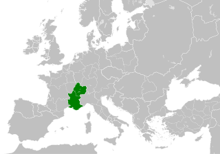
| ۲۲ مهٔ ۲۰۱۶، ساعت ۱۵:۳۹ |  | ۴۸۵ در ۳۴۰ (۱٫۲۳ مگابایت) | Alphathon | == {{int:filedesc}} == {{Inkscape}} {{Information |Description={{en|A map of the Kingdom of Arles/Arelat/Burgundy within Europe circa 1000 CE. The main subdivisions of the Byzantine Empire, Holy Roman Empire, Burgundy, France a... |
کاربرد پرونده
صفحهٔ زیر از این تصویر استفاده میکند:
کاربرد سراسری پرونده
ویکیهای دیگر زیر از این پرونده استفاده میکنند:
- کاربرد در ast.wikipedia.org
- کاربرد در az.wikipedia.org
- کاربرد در ca.wikipedia.org
- کاربرد در cs.wikipedia.org
- کاربرد در el.wikipedia.org
- کاربرد در en.wikipedia.org
- کاربرد در eo.wikipedia.org
- کاربرد در es.wikipedia.org
- کاربرد در fi.wikipedia.org
- کاربرد در fr.wikipedia.org
- کاربرد در he.wikipedia.org
- کاربرد در hu.wikipedia.org
- کاربرد در id.wikipedia.org
- کاربرد در it.wikipedia.org
- کاربرد در it.wikiquote.org
- کاربرد در ko.wikipedia.org
- کاربرد در lv.wikipedia.org
- کاربرد در mt.wikipedia.org
- کاربرد در pl.wikipedia.org
- کاربرد در ro.wikipedia.org
- کاربرد در sl.wikipedia.org
- کاربرد در th.wikipedia.org
- کاربرد در uk.wikipedia.org
- کاربرد در vi.wikipedia.org
- کاربرد در www.wikidata.org
- کاربرد در zh.wikipedia.org
.svg)