پرونده:Map North America 1566.jpg
پروندهٔ اصلی (۹۰۰ × ۶۴۰ پیکسل، اندازهٔ پرونده: ۱۵۱ کیلوبایت، نوع MIME پرونده: image/jpeg)
این پرونده در ویکیانبار موجود است. محتویات صفحهٔ توصیف آن در زیر نمایش داده میشود. |
خلاصه

|
This map has been uploaded by Electionworld from en.wikipedia.org to enable the |
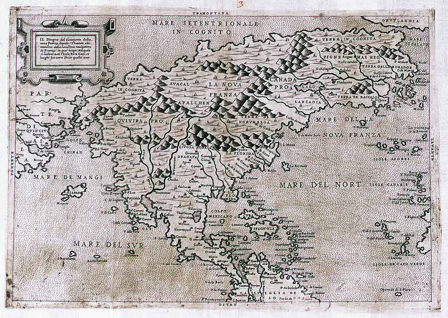
Il designo del discoperto della Nova Franza by Paolo Forlani, ca. 1566 – source
One of the first maps of North America to note the name "Canada" ("pro.") (top right).
اجازهنامه
|
این اثر در کشورهایی و مناطقی که مدت زمان حق تکثیر، عمر پدیدآورنده بعلاوه 70 سال یا کمتر بعد از مرگ او است، در مالکیت عمومی قرار دارد.
| |
| این پرونده تحت قانون حق تکثیر محدودیت آزاد منتشر شده که شامل تمامی حقوق مربوطه و حقوق نزدیک به آن میشود. | |
تاریخچهٔ پرونده
روی تاریخ/زمانها کلیک کنید تا نسخهٔ مربوط به آن هنگام را ببینید.
| تاریخ/زمان | بندانگشتی | ابعاد | کاربر | توضیح | |
|---|---|---|---|---|---|
| کنونی | ۲۹ نوامبر ۲۰۰۶، ساعت ۲۲:۵۴ | | ۹۰۰ در ۶۴۰ (۱۵۱ کیلوبایت) | Electionworld | {{ew|en|E Pluribus Anthony}} ''Il designo del discoperto della Nova Franza'' by Paolo Forlani, ''ca.'' 1566 – [http://www.collectionscanada.ca/maps/3_0_exp/05140303_e.html source] One of the first maps of North America to note the [[Canada's na |
کاربرد پرونده
صفحهٔ زیر از این تصویر استفاده میکند:
کاربرد سراسری پرونده
ویکیهای دیگر زیر از این پرونده استفاده میکنند:
- کاربرد در bg.wikipedia.org
- کاربرد در ca.wikipedia.org
- کاربرد در cs.wikipedia.org
- کاربرد در de.wikipedia.org
- کاربرد در en.wikipedia.org
- کاربرد در es.wikipedia.org
- کاربرد در et.wikipedia.org
- کاربرد در fi.wikipedia.org
- کاربرد در fr.wikipedia.org
- کاربرد در he.wikipedia.org
- کاربرد در id.wikipedia.org
- کاربرد در it.wikipedia.org
- کاربرد در oc.wikipedia.org
- کاربرد در pt.wikipedia.org
- کاربرد در ro.wikipedia.org
- کاربرد در sv.wikipedia.org
- کاربرد در tr.wikipedia.org
- کاربرد در uk.wikipedia.org