پرونده:PIA16105 malin04ano-br2.jpg

پروندهٔ اصلی (۱٬۰۲۴ × ۶۸۴ پیکسل، اندازهٔ پرونده: ۱۲۵ کیلوبایت، نوع MIME پرونده: image/jpeg)
این پرونده در ویکیانبار موجود است. محتویات صفحهٔ توصیف آن در زیر نمایش داده میشود. |
خلاصه
| توضیح |
English: 08.27.2012
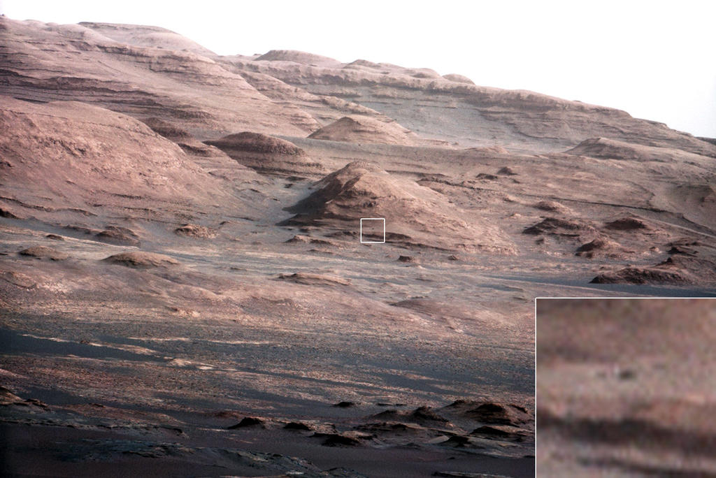
Layers at the Base of Mount Sharp A chapter of the layered geological history of Mars is laid bare in this postcard from NASA's Curiosity rover. The image shows the base of Mount Sharp, the rover's eventual science destination. This image is a portion of a larger image taken by Curiosity's 100-millimeter Mast Camera on Aug. 23, 2012. See http://photojournal.jpl.nasa.gov/catalog/PIA16104. Scientists enhanced the color in one version to show the Martian scene under the lighting conditions we have on Earth, which helps in analyzing the terrain. For scale, an annotated version of the figure highlights a dark rock that is approximately the same size as Curiosity. The pointy mound in the center of the image, looming above the rover-sized rock, is about 1,000 feet (300 meters) across and 300 feet (100 meters) high. To see a close-up of the layered buttes of Mount Sharp, see http://photojournal.jpl.nasa.gov/catalog/PIA16105. Image Credit: NASA/JPL-Caltech/MSSS |
| تاریخ | |
| منبع | http://mars.jpl.nasa.gov/msl/images/PIA16105_malin04ano-br2.jpg |
| پدیدآور | NASA/JPL-Caltech/MSSS |
اجازهنامه
| این پرونده در مالکیت عمومی قرار دارد چرا که توسط ناسا ایجاد شده است. سیاست حق تکثیر ناسا بیان میکند که «مواد ناسا با حق تکثیر محافظت نمیشوند، مگراینکه ذکر شده باشد». (Template:PD-USGov، صفحهٔ سیاست حق تکثیر ناسا یا سیاست جیپیال استفاده از تصاویر را ببینید.) | ||
 |
هشدارها:
|
تاریخچهٔ پرونده
روی تاریخ/زمانها کلیک کنید تا نسخهٔ مربوط به آن هنگام را ببینید.
| تاریخ/زمان | بندانگشتی | ابعاد | کاربر | توضیح | |
|---|---|---|---|---|---|
| کنونی | ۲۷ اوت ۲۰۱۲، ساعت ۲۳:۴۴ | | ۱٬۰۲۴ در ۶۸۴ (۱۲۵ کیلوبایت) | Drbogdan | User created page with UploadWizard |
کاربرد پرونده
صفحههای زیر از این تصویر استفاده میکنند:
کاربرد سراسری پرونده
ویکیهای دیگر زیر از این پرونده استفاده میکنند:
- کاربرد در bn.wikipedia.org
- کاربرد در ca.wikipedia.org
- کاربرد در en.wikipedia.org
- کاربرد در es.wikipedia.org
- کاربرد در kk.wikipedia.org
- کاربرد در ko.wikipedia.org
- کاربرد در ro.wikipedia.org
- کاربرد در test.wikipedia.org
- کاربرد در tr.wikipedia.org
- کاربرد در uk.wikipedia.org
- کاربرد در zh.wikipedia.org