پرونده:Safe trail map NPS1962.jpg

اندازهٔ این پیشنمایش: ۸۰۰ × ۵۳۲ پیکسل. کیفیتهای دیگر: ۳۲۰ × ۲۱۳ پیکسل | ۶۴۰ × ۴۲۶ پیکسل | ۹۰۰ × ۵۹۹ پیکسل.
پروندهٔ اصلی (۹۰۰ × ۵۹۹ پیکسل، اندازهٔ پرونده: ۴۸ کیلوبایت، نوع MIME پرونده: image/jpeg)
این پرونده در ویکیانبار موجود است. محتویات صفحهٔ توصیف آن در زیر نمایش داده میشود. |
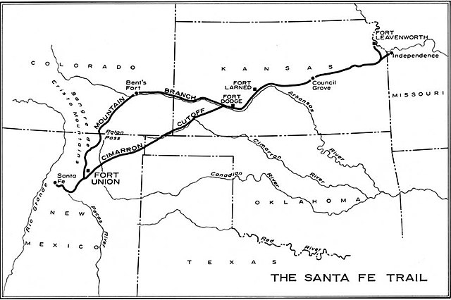
| توضیح | Map of the historic Santa Fe Trail in the southwestern United States as around 1860 | |||
| تاریخ | ||||
| منبع | http://www.cr.nps.gov/history/online_books/hh/35/images/hh35b1.jpg - from Robert M. Utley, FORT UNION - National Monument - New Mexico, National Park Service, Historical Handbook Series No. 35, Washington, D.C., 1962 | |||
| پدیدآور | NPS Graphics | |||
| اجازهنامه (استفادهٔ مجدد از این پرونده) |
|
تاریخچهٔ پرونده
روی تاریخ/زمانها کلیک کنید تا نسخهٔ مربوط به آن هنگام را ببینید.
| تاریخ/زمان | بندانگشتی | ابعاد | کاربر | توضیح | |
|---|---|---|---|---|---|
| کنونی | ۲۰ اکتبر ۲۰۰۶، ساعت ۰۸:۳۸ | | ۹۰۰ در ۵۹۹ (۴۸ کیلوبایت) | H-stt | {{Information |Description= Map of the historic ''Santa Fe Trail'' in the southwestern United States as around 1860 |Source= http://www.cr.nps.gov/history/online_books/hh/35/images/hh35b1.jpg - from Robert M. Utley, ''FORT UNION - National Monument - New |
کاربرد پرونده
صفحهٔ زیر از این تصویر استفاده میکند:
کاربرد سراسری پرونده
ویکیهای دیگر زیر از این پرونده استفاده میکنند:
- کاربرد در de.wikipedia.org
- کاربرد در en.wikipedia.org
- کاربرد در es.wikipedia.org
- کاربرد در it.wikipedia.org
- کاربرد در no.wikipedia.org
- کاربرد در sr.wikipedia.org
- کاربرد در sv.wikipedia.org
- کاربرد در www.wikidata.org