پرونده:TEIDE.JPG
اندازهٔ این پیشنمایش: ۸۰۰ × ۴۸۴ پیکسل. کیفیتهای دیگر: ۳۲۰ × ۱۹۴ پیکسل | ۶۴۰ × ۳۸۸ پیکسل | ۱٬۰۲۴ × ۶۲۰ پیکسل | ۱٬۲۸۰ × ۷۷۵ پیکسل | ۲٬۵۶۰ × ۱٬۵۵۰ پیکسل | ۳٬۶۰۰ × ۲٬۱۸۰ پیکسل.
پروندهٔ اصلی (۳٬۶۰۰ × ۲٬۱۸۰ پیکسل، اندازهٔ پرونده: ۱٫۸۹ مگابایت، نوع MIME پرونده: image/jpeg)
این پرونده در ویکیانبار موجود است. محتویات صفحهٔ توصیف آن در زیر نمایش داده میشود. |
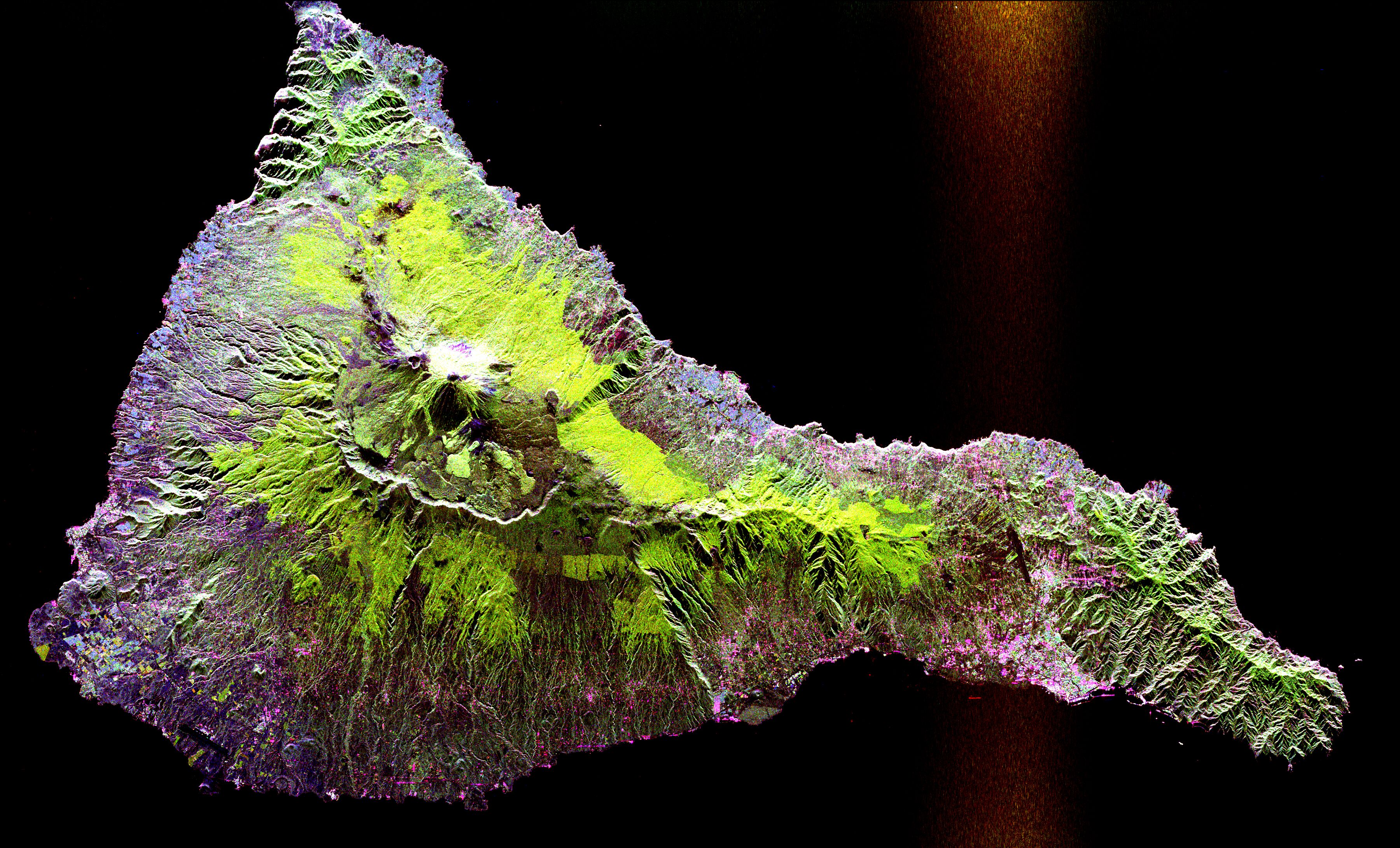
Space radar image of Teide, taken in 1994. NASA's description:
- This radar image shows the Teide volcano on the island of Tenerife in the Canary Islands. The Canary Islands, part of Spain, are located in the eastern Atlantic Ocean off the coast of Morocco. Teide has erupted only once in the 20th Century, in 1909, but is considered a potentially threatening volcano due to its proximity to the city of Santa Cruz de Tenerife, shown in this image as the purple and white area on the lower right edge of the island. The summit crater of Teide, clearly visible in the left center of the image, contains lava flows of various ages and roughnesses that appear in shades of green and brown. Different vegetation zones, both natural and agricultural, are detected by the radar as areas of purple, green and yellow on the volcano's flanks. Scientists are using images such as this to understand the evolution of the structure of Teide, especially the formation of the summit caldera and the potential for collapse of the flanks. The volcano is one of 15 identified by scientists as potentially hazardous to local populations, as part of the international
- The image was acquired by the Spaceborne Imaging Radar-C/X-Band Synthetic Aperture Radar (SIR-C/X-SAR) onboard the space shuttle Endeavour on October 11, 1994. SIR-C/X-SAR, a joint mission of the German, Italian and the United States space agencies, is part of NASA's Mission to Planet Earth. The image is centered at 28.3 degrees North latitude and 16.6 degrees West longitude. North is toward the upper right. The area shown measures 90 kilometers by 54.5 kilometers (55.8 miles by 33.8 miles). The colors in the image are assigned to different frequencies and polarizations of the radar as follows: red is L-band horizontally transmitted, horizontally received; green is L-band horizontally transmitted, vertically received; blue is C-band horizontally transmitted, vertically received.
Taken from NASA's Visible Earth: [1]. Converted to JPEG.
| این پرونده در مالکیت عمومی قرار دارد چرا که توسط ناسا ایجاد شده است. سیاست حق تکثیر ناسا بیان میکند که «مواد ناسا با حق تکثیر محافظت نمیشوند، مگراینکه ذکر شده باشد». (Template:PD-USGov، صفحهٔ سیاست حق تکثیر ناسا یا سیاست جیپیال استفاده از تصاویر را ببینید.) | ||
 |
هشدارها:
|
تاریخچهٔ پرونده
روی تاریخ/زمانها کلیک کنید تا نسخهٔ مربوط به آن هنگام را ببینید.
| تاریخ/زمان | بندانگشتی | ابعاد | کاربر | توضیح | |
|---|---|---|---|---|---|
| کنونی | ۳۰ آوریل ۲۰۰۵، ساعت ۱۵:۱۵ | | ۳٬۶۰۰ در ۲٬۱۸۰ (۱٫۸۹ مگابایت) | Hautala | |
| ۲۳ آوریل ۲۰۰۵، ساعت ۱۲:۵۸ |  | ۱٬۰۲۴ در ۷۶۸ (۱۰۹ کیلوبایت) | David.gaya | {{NASA}} |
کاربرد پرونده
صفحههای زیر از این تصویر استفاده میکنند:
کاربرد سراسری پرونده
ویکیهای دیگر زیر از این پرونده استفاده میکنند:
- کاربرد در ar.wikipedia.org
- کاربرد در be.wikipedia.org
- کاربرد در ca.wikipedia.org
- کاربرد در cs.wikipedia.org
- کاربرد در da.wikipedia.org
- کاربرد در de.wikipedia.org
- کاربرد در en.wikipedia.org
- کاربرد در en.wikiversity.org
- کاربرد در id.wikipedia.org
- کاربرد در no.wikipedia.org
- کاربرد در pt.wikipedia.org
- کاربرد در ta.wikipedia.org
- کاربرد در uk.wikipedia.org
- کاربرد در uz.wikipedia.org
- کاربرد در www.wikidata.org
- کاربرد در yo.wikipedia.org