پرونده:Waldseemuller map, complete.jpg

پروندهٔ اصلی (۲۹٬۷۰۰ × ۱۶٬۵۰۰ پیکسل، اندازهٔ پرونده: ۹۷٫۹۷ مگابایت، نوع MIME پرونده: image/jpeg)
این پرونده در ویکیانبار موجود است. محتویات صفحهٔ توصیف آن در زیر نمایش داده میشود. |
| هشدار | بعضی از مرورگرها با نمایش این تصویر با وضوح تصویر بالا مشکل دارند: این تصویر تعداد زیادی نقطه دارد و ممکن است به درستی در مرورگر شما بارگیری نشود یا باعث متوقف شدن مرورگر شما شود. |
|---|
خلاصه
| توضیح |
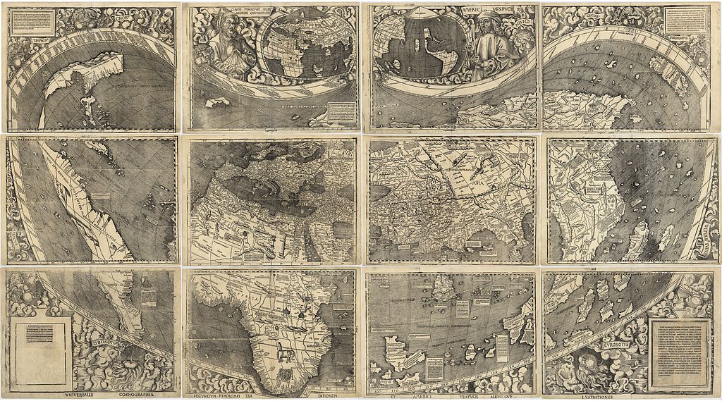
The Waldseemüller map, the first map to include the name "America" and the first to depict the Americas as separate from Asia. The map comprises 12 separate sheets, shown here into a single image. There is only one surviving copy of the map, which was purchased by the Library of Congress in 2001 for $10 million. Its Latin title is "Universalis cosmographia secundum Ptholomaei traditionem et Americi Vespucii alioru[m]que lustrationes". Converted from the LoC's JPEG2000 file to JPEG using ImageMagick with 81% quality (to fit under the current 100MB upload limit on Wikimedia Commons). |
|||||||||||||||||||||||
| تاریخ | ||||||||||||||||||||||||
| منبع | file, description. | |||||||||||||||||||||||
| پدیدآور |
|
|||||||||||||||||||||||
| دیگر نسخهها |
|
|||||||||||||||||||||||


اجازهنامه
|
این اثر در کشورهایی و مناطقی که مدت زمان حق تکثیر، عمر پدیدآورنده بعلاوه 100 سال یا کمتر بعد از مرگ او است، در مالکیت عمومی قرار دارد. | |
| این پرونده تحت قانون حق تکثیر محدودیت آزاد منتشر شده که شامل تمامی حقوق مربوطه و حقوق نزدیک به آن میشود. | |
تاریخچهٔ پرونده
روی تاریخ/زمانها کلیک کنید تا نسخهٔ مربوط به آن هنگام را ببینید.
| تاریخ/زمان | بندانگشتی | ابعاد | کاربر | توضیح | |
|---|---|---|---|---|---|
| کنونی | ۲۶ مهٔ ۲۰۱۱، ساعت ۰۰:۰۶ | | ۲۹٬۷۰۰ در ۱۶٬۵۰۰ (۹۷٫۹۷ مگابایت) | Avenue | {{LargeImage}} == {{int:filedesc}} == {{Information |Description=The Waldseemüller map, the first map to include the name "America" and the first to depict the Americas as separate from Asia. The map comprises 12 separate she |
کاربرد پرونده
این پرونده در هیچ صفحهای به کار نرفته است.