پرونده:Warszawa Powstanie 1944-09-10.jpg

اندازهٔ این پیشنمایش: ۴۸۳ × ۶۰۰ پیکسل. کیفیتهای دیگر: ۱۹۳ × ۲۴۰ پیکسل | ۳۸۷ × ۴۸۰ پیکسل | ۶۱۹ × ۷۶۸ پیکسل | ۸۲۵ × ۱٬۰۲۴ پیکسل | ۱٬۶۰۰ × ۱٬۹۸۶ پیکسل.
پروندهٔ اصلی (۱٬۶۰۰ × ۱٬۹۸۶ پیکسل، اندازهٔ پرونده: ۲٫۴۱ مگابایت، نوع MIME پرونده: image/jpeg)
این پرونده در ویکیانبار موجود است. محتویات صفحهٔ توصیف آن در زیر نمایش داده میشود. |
خلاصه
| توضیح |
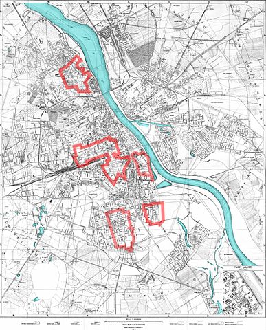
The areas of Warsaw controlled by the Home Army on September 10th, 1944, during the Warsaw Uprising. This map was based on a variety of sources and is pretty accurate, but don't expect any map to be any more or any less accurate: there were no stable front-lines and the ones presented here are only for orientation. Also note that not all areas outside of the Polish zone of control were controlled by the Germans. |
| تاریخ | |
| منبع |
|
| پدیدآور | Halibutt |
| دیگر نسخهها | SVG version and much larger versions available at request. |
اجازهنامه
Since the legal status of the above comment has been questioned, I hereby grant anyone the right to treat it as either a standard copyright notice, invariant section, legal statement, legal advice, friendly suggestion or a mere comment, depending on his or hers own choice. |
|

The following is a list of maps created by Halibutt and uploaded to commons, as well as their present and projected derivatives.
| Parent Image | Image | Description | |||||||||||
|---|---|---|---|---|---|---|---|---|---|---|---|---|---|
| Maps by Halibutt | |||||||||||||
| Image:Rzeczpospolita.png | Image:Rzeczpospolita.png | The Republic in 17th and 18th century | |||||||||||
| Image:Rzeczpospolita 1600.png | The Republic after the Treaty of Dywilino | ||||||||||||
| Image:Rzeczpospolita voivodships.png | Voivodships of The Republic | ||||||||||||
| Image:Rzeczpospolita_Potop.png | The Republic during The Deluge and Chmielnicki Uprising, with major battles of the era marked | ||||||||||||
| Magnates and their lands and domains | |||||||||||||
| 1st • 2nd • 3rd | Partitions of Poland | ||||||||||||
| War of the constitution | |||||||||||||
| Image:Rzeczpospolita.xcf | SOURCE FILE - GIMP format | ||||||||||||
| Image:Poland 1939.png | Image:Poland 1939.png | Poland in 1939 | |||||||||||
| Image:Dywizje wrzesien 1.png | Order of Battle on September 1st, during the Polish Defence War of 1939 | ||||||||||||
| Image:Poland 1939.xcf | SOURCE FILE - GIMP format | ||||||||||||
| Image:Polska kontur bialy.png | Image:Polska kontur bialy.png | Contour map of Poland AD 1999, for use with various locator maps | |||||||||||
| Image:Rzeczpospolita 1923.png | Image:Rzeczpospolita 1923.png | Map of Poland 1918-1939, currently under development | |||||||||||
| Image:PBW March 1919.png | Polish-Bolshevik War - fronts in March of 1919 | ||||||||||||
| Image:PBW December 1919.png | Polish-Bolshevik War - fronts in December of 1919 | ||||||||||||
| Image:PBW June 1920.png | Polish-Bolshevik War - fronts in July of 1920 | ||||||||||||
| Image:PBW August 1920.png | Polish-Bolshevik War - fronts in August of 1920 | ||||||||||||
| Polish Defence War of 1939 | |||||||||||||
| Polish areas annexed by Germany, Lithuania, Slovakia and the Soviet Union | |||||||||||||
| German concentration camps in Poland | |||||||||||||
| Curzon line | |||||||||||||
| Major battles of the Polish-Bolshevik War | |||||||||||||
| names • no names | Polish/Czechoslovak/Lithuanian/German/Ukrainian claims in 1920's | ||||||||||||
| Image:Rzeczpospolita Central Lithuania.png | Central Lithuania | ||||||||||||
| Image:Rzeczpospolita Lithuania claims.png | Central Lithuania as compared with other Lithuanian claims | ||||||||||||
| Image:Rzeczpospolita 1789-1920.png | Post-1922 borders compared with the territory of Poland before the partitions | ||||||||||||
| Warsaw Uprising and the Operation Tempest | |||||||||||||
| Poland partitioned between the Soviets and the Germans | |||||||||||||
| Image:Rzeczpospolita 1939 Polish divisions.png | Polish divisions on September 1, 1939 | ||||||||||||
| Home Army inspectorates | |||||||||||||
| Image:Rzeczpospolita 1922.xcf | SOURCE FILE - GIMP format | ||||||||||||
| Image:Rzeczpospolita 1937.svg | Vector version!!!! | layered version available on request | |||||||||||
تاریخچهٔ پرونده
روی تاریخ/زمانها کلیک کنید تا نسخهٔ مربوط به آن هنگام را ببینید.
| تاریخ/زمان | بندانگشتی | ابعاد | کاربر | توضیح | |
|---|---|---|---|---|---|
| کنونی | ۹ مهٔ ۲۰۰۷، ساعت ۱۴:۱۴ | | ۱٬۶۰۰ در ۱٬۹۸۶ (۲٫۴۱ مگابایت) | Halibutt | {{Information |Description=The areas of Warsaw controlled by the Home Army on September 10th, 1944, during the Warsaw Uprising. <br>This map was based on a variety of sources and is pretty accurate, but don't expect any map to be any more or any less |
کاربرد پرونده
صفحهٔ زیر از این تصویر استفاده میکند:
کاربرد سراسری پرونده
ویکیهای دیگر زیر از این پرونده استفاده میکنند:
- کاربرد در azb.wikipedia.org
- کاربرد در cs.wikipedia.org
- کاربرد در en.wikipedia.org
- کاربرد در he.wikipedia.org
- کاربرد در hu.wikipedia.org
- کاربرد در sr.wikipedia.org