پرونده:1865 Bellin Sea Chart of Western Africa ( Senegal, Gambia, Guinea, etc.) - Geographicus - WestAfrica2-bellin-1765.jpg

اندازهٔ این پیشنمایش: ۳۸۰ × ۵۹۹ پیکسل. کیفیتهای دیگر: ۱۵۲ × ۲۴۰ پیکسل | ۳۰۴ × ۴۸۰ پیکسل | ۴۸۷ × ۷۶۸ پیکسل | ۶۴۹ × ۱٬۰۲۴ پیکسل | ۱٬۲۹۹ × ۲٬۰۴۸ پیکسل | ۴٬۰۰۰ × ۶٬۳۰۶ پیکسل.
پروندهٔ اصلی (۴٬۰۰۰ × ۶٬۳۰۶ پیکسل، اندازهٔ پرونده: ۴٫۵۴ مگابایت، نوع MIME پرونده: image/jpeg)
این پرونده در ویکیانبار موجود است. محتویات صفحهٔ توصیف آن در زیر نمایش داده میشود. |
_-_Geographicus_-_WestAfrica2-bellin-1765.jpg?uselang=fa)
| Jacques-Nicolas Bellin: Carte Reduite Des Costes Occidentales D’Afrique.
( |
||||||||||||||||||||
|---|---|---|---|---|---|---|---|---|---|---|---|---|---|---|---|---|---|---|---|---|
| هنرمند |
|
|||||||||||||||||||
| عنوان |
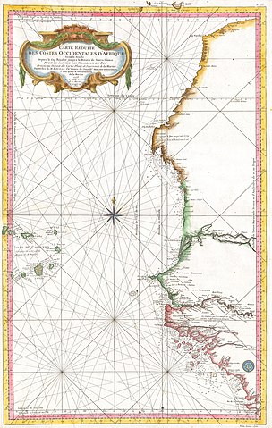
Carte Reduite Des Costes Occidentales D’Afrique. |
|||||||||||||||||||
| توضیح |
English: This large nautical chart of Western African was produced by the French Cartographer Jacques-Nicolas Bellin. Depicts Western Africa from The Canary Islands South through Western Sahara, Senegal, Guinea-Bissau, the Gambia, Guinea, and Sierra Leone. This is primarily a costal chart with depth soundings and navigational marks, but does show the river courses and considerable interior details in the Cape Verde Islands. The remainder of the interior remains largely unmapped. There is a large decorative title cartouche in the upper left as well as a Depot del la Marine stamp in the lower right. All in all, an extraordinary sea chart of Africa’s northwest coast. |
|||||||||||||||||||
| تاریخ | ۱۷۶۵ | |||||||||||||||||||
| ابعاد | بلندی: ۲۲٫۰ اینچ (۵۵٫۸ سانتیمتر)؛ عرض: ۳۵٫۰ اینچ (۸۸٫۹ سانتیمتر) | |||||||||||||||||||
| آیدی |
Geographicus link: WestAfrica2-bellin-1765 |
|||||||||||||||||||
| منبع/عکاس |
|
|||||||||||||||||||
| اجازهنامه (استفادهٔ مجدد از این پرونده) |
|
|||||||||||||||||||
تاریخچهٔ پرونده
روی تاریخ/زمانها کلیک کنید تا نسخهٔ مربوط به آن هنگام را ببینید.
| تاریخ/زمان | بندانگشتی | ابعاد | کاربر | توضیح | |
|---|---|---|---|---|---|
| کنونی | ۲۴ مارس ۲۰۱۱، ساعت ۱۰:۵۵ | | ۴٬۰۰۰ در ۶٬۳۰۶ (۴٫۵۴ مگابایت) | BotMultichillT | {{subst:User:Multichill/Geographicus |link=http://www.geographicus.com/P/AntiqueMap/WestAfrica2-bellin-1765 |product_name=1865 Bellin Sea Chart of Western Africa ( Senegal, Gambia, Guinea, etc.) |map_title=Carte Reduite Des Costes Occidentales D’Afrique |
کاربرد پرونده
صفحهٔ زیر از این تصویر استفاده میکند:
کاربرد سراسری پرونده
ویکیهای دیگر زیر از این پرونده استفاده میکنند:
- کاربرد در de.wikipedia.org
- کاربرد در en.wikipedia.org
- کاربرد در es.wikipedia.org
- کاربرد در fi.wikipedia.org
- کاربرد در it.wikipedia.org
- کاربرد در uk.wikipedia.org
_-_Geographicus_-_WestAfrica2-bellin-1765.jpg)