پرونده:A Long Barrow - geograph.org.uk - 21533.jpg
تفکیکپذیری بالاتری در دسترس نیست.
A_Long_Barrow_-_geograph.org.uk_-_21533.jpg (۶۴۰ × ۴۸۰ پیکسل، اندازهٔ پرونده: ۹۵ کیلوبایت، نوع MIME پرونده: image/jpeg)
این پرونده در ویکیانبار موجود است. محتویات صفحهٔ توصیف آن در زیر نمایش داده میشود. |
خلاصه
| توضیح |
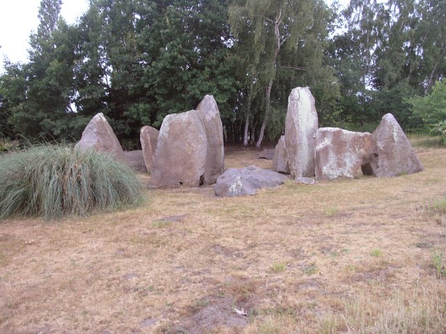
English: A Long Barrow. This has got to be the most impressive garden feature I've seen. In the grounds of a private residence, this is the best preserved long barrow in this area of Kent. What remains is the stone structure, which originally would have been covered by earth. 1,500 years older than Stonehenge, this is an ancient burial chamber built using local stones and originally covered by earth, with the chamber itself being between the two middle stones and the other stones supporting the earth structure. The central stones are about 3m tall and would have originally been topped by a capping stone (now just visible in the picture on the ground behind the stones). There are many other barrows in this area of Kent, but this has been re-built in the 1950s when the barrow was archaeologically investigated. |
| تاریخ | |
| منبع | From geograph.org.uk |
| پدیدآور | Hywel Williams |
| انتساب (required by the license) | Hywel Williams / A Long Barrow / |
| مختصات دوربین | | محل قرارگیری این نگاره و سایر نگارهها در: نقشهٔ شهری باز |
|---|
_heading:270.00&language=fa)
| مختصات شیء | | محل قرارگیری این نگاره و سایر نگارهها در: نقشهٔ شهری باز |
|---|
_heading:270.00&language=fa)
اجازهنامه

|
این نگاره از مجموعهٔ پروژهٔ Geograph گرفته شدهاست. این صفحهٔ عکسها را در وبگاه Geograph برای جزئیات تماس با عکاس ببینید. حق تکثیر این تصویر به Hywel Williams تعلق دارد و برای استفادهٔ مجدد تحت Creative Commons Attribution-ShareAlike 2.0 مجوزدهی شدهاست.
|
این پرونده با اجازهنامهٔ کریتیو کامانز Attribution-Share Alike 2.0 عمومی منتشر شده است.
انتساب: Hywel Williams
- شما اجازه دارید:
- برای به اشتراک گذاشتن – برای کپی، توزیع و انتقال اثر
- تلفیق کردن – برای انطباق اثر
- تحت شرایط زیر:
- انتساب – شما باید اعتبار مربوطه را به دست آورید، پیوندی به مجوز ارائه دهید و نشان دهید که آیا تغییرات ایجاد شدهاند یا خیر. شما ممکن است این کار را به هر روش منطقی انجام دهید، اما نه به هر شیوهای که پیشنهاد میکند که مجوزدهنده از شما یا استفادهتان حمایت کند.
- انتشار مشابه – اگر این اثر را تلفیق یا تبدیل میکنید، یا بر پایه آن اثری دیگر خلق میکنید، میبایست مشارکتهای خود را تحت مجوز یکسان یا مشابه با ا اصل آن توزیع کنید.
تاریخچهٔ پرونده
روی تاریخ/زمانها کلیک کنید تا نسخهٔ مربوط به آن هنگام را ببینید.
| تاریخ/زمان | بندانگشتی | ابعاد | کاربر | توضیح | |
|---|---|---|---|---|---|
| کنونی | ۳۰ ژانویهٔ ۲۰۱۰، ساعت ۰۱:۲۱ | | ۶۴۰ در ۴۸۰ (۹۵ کیلوبایت) | GeographBot | == {{int:filedesc}} == {{Information |description={{en|1=A Long Barrow. This has got to be the most impressive garden feature I've seen. In the grounds of a private residence, this is the best preserved long barrow in this area of Kent. What remains is |
کاربرد پرونده
صفحهٔ زیر از این تصویر استفاده میکند:
کاربرد سراسری پرونده
ویکیهای دیگر زیر از این پرونده استفاده میکنند:
- کاربرد در ar.wikipedia.org
- کاربرد در de.wikipedia.org
- کاربرد در en.wikipedia.org
- کاربرد در id.wikipedia.org
- کاربرد در ml.wikipedia.org