پرونده:Australia Victoria Southern Grampians Shire location map.svg

حجم پیشنمایش PNG این SVG file:۵۳۳ × ۴۹۱ پیکسل کیفیتهای دیگر: ۲۶۱ × ۲۴۰ پیکسل | ۵۲۱ × ۴۸۰ پیکسل | ۸۳۴ × ۷۶۸ پیکسل | ۱٬۱۱۲ × ۱٬۰۲۴ پیکسل | ۲٬۲۲۳ × ۲٬۰۴۸ پیکسل.
پروندهٔ اصلی (پروندهٔ اسویجی، با ابعاد ۵۳۳ × ۴۹۱ پیکسل، اندازهٔ پرونده: ۶۴۰ کیلوبایت)
این پرونده در ویکیانبار موجود است. محتویات صفحهٔ توصیف آن در زیر نمایش داده میشود. |
| توضیح |
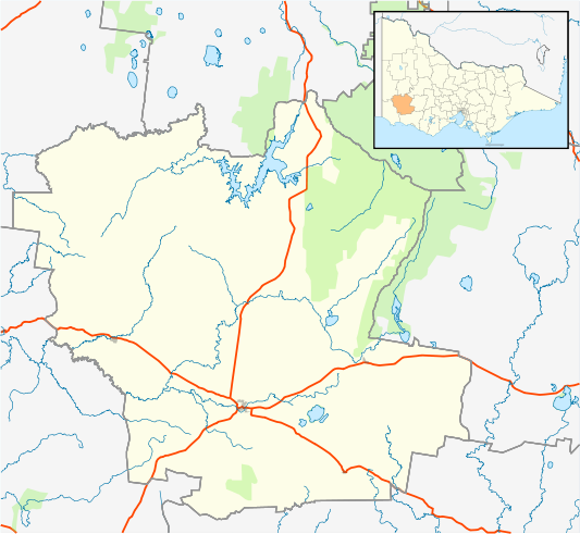
English: Blank map of w:Southern Grampians Shire, Victoria, Australia, with the following information shown:
Geographic limits:
|
||
| منبع | اثر شخصی + VicMap Lite | ||
| پدیدآور | Cassowary |

تاریخچهٔ پرونده
روی تاریخ/زمانها کلیک کنید تا نسخهٔ مربوط به آن هنگام را ببینید.
| تاریخ/زمان | بندانگشتی | ابعاد | کاربر | توضیح | |
|---|---|---|---|---|---|
| کنونی | ۱۸ فوریهٔ ۲۰۱۱، ساعت ۱۶:۰۰ | | ۵۳۳ در ۴۹۱ (۶۴۰ کیلوبایت) | Cassowary | {{Information |Description ={{en|1=Blank map of w:Southern Grampians Shire, Victoria, Australia, with the following information shown: * LGA boundaries * Coastline, lakes and rivers * Highways and freeways * Urban areas * Parks Geographic limits: |
کاربرد پرونده
صفحهٔ زیر از این تصویر استفاده میکند:
کاربرد سراسری پرونده
ویکیهای دیگر زیر از این پرونده استفاده میکنند:
- کاربرد در ar.wikipedia.org
- کاربرد در ceb.wikipedia.org
- کاربرد در en.wikipedia.org
- Shire of Southern Grampians
- Hamilton, Victoria
- Coleraine, Victoria
- Penshurst, Victoria
- Dunkeld, Victoria
- Glenthompson, Victoria
- Template:Towns in Southern Grampians Shire
- Tabor, Victoria
- Tarrington, Victoria
- Balmoral, Victoria
- Branxholme, Victoria
- Byaduk
- Cavendish, Victoria
- Module:Location map/data/Australia Victoria Shire of Southern Grampians/doc
- Pigeon Ponds
- Konongwootong
- Tahara, Victoria
- Module:Location map/data/Australia Victoria Shire of Southern Grampians
- User:Viatori/sandbox
- User:ThylacineHunter/LGA
- Brit Brit, Victoria
- Bochara, Victoria
- Gringegalgona, Victoria
- کاربرد در kn.wikipedia.org
- کاربرد در si.wikipedia.org
- کاربرد در tr.wikipedia.org
- کاربرد در uz.wikipedia.org
- کاربرد در war.wikipedia.org