پرونده:Balkans 6th century.svg

حجم پیشنمایش PNG این SVG file:۸۰۰ × ۴۳۱ پیکسل کیفیتهای دیگر: ۳۲۰ × ۱۷۳ پیکسل | ۶۴۰ × ۳۴۵ پیکسل | ۱٬۰۲۴ × ۵۵۲ پیکسل | ۱٬۲۸۰ × ۶۹۰ پیکسل | ۲٬۵۶۰ × ۱٬۳۸۱ پیکسل | ۱٬۴۰۰ × ۷۵۵ پیکسل.
پروندهٔ اصلی (پروندهٔ اسویجی، با ابعاد ۱٬۴۰۰ × ۷۵۵ پیکسل، اندازهٔ پرونده: ۱٫۸۳ مگابایت)
این پرونده در ویکیانبار موجود است. محتویات صفحهٔ توصیف آن در زیر نمایش داده میشود. |
خلاصه
| توضیح |
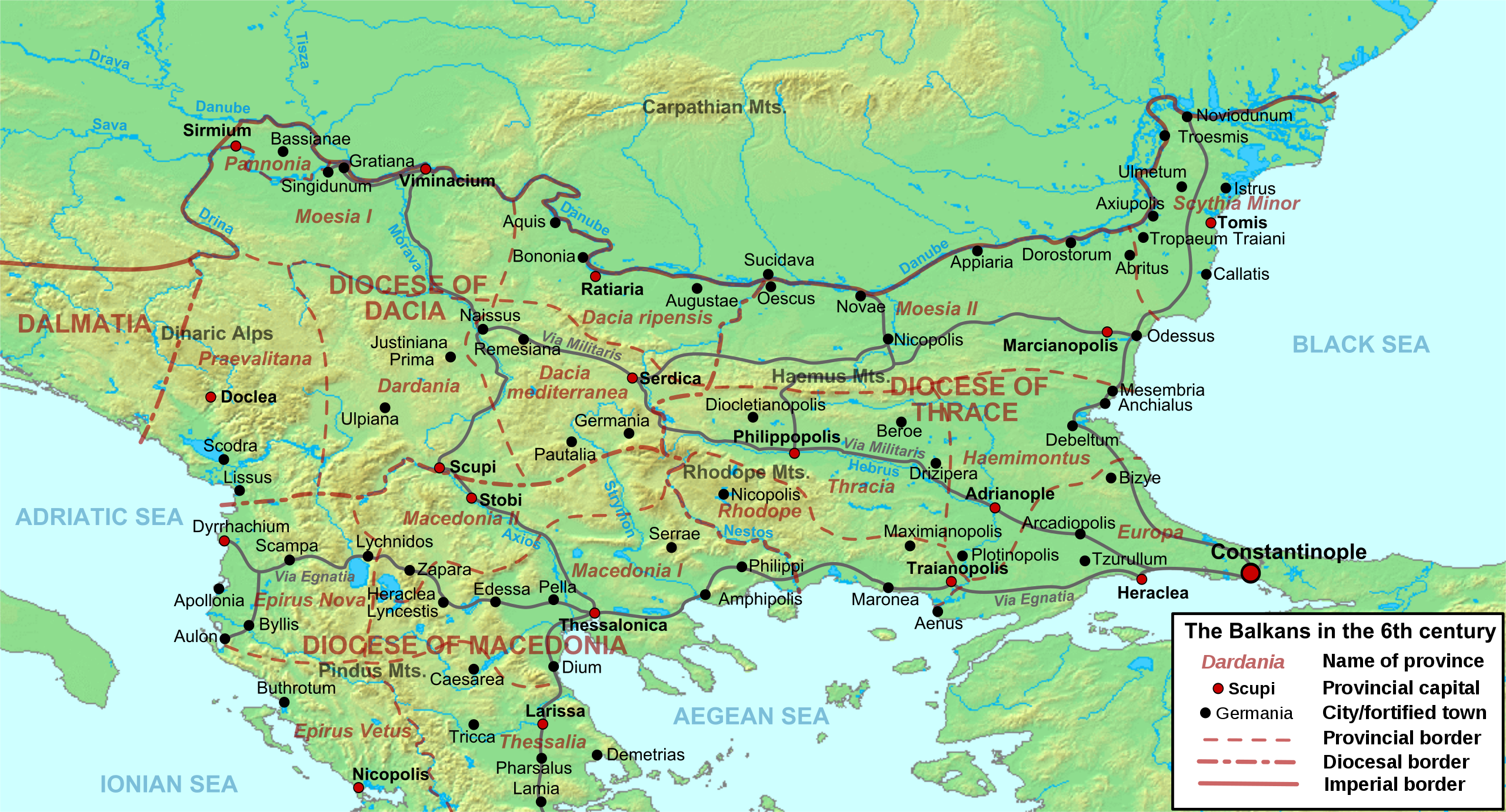
Deutsch: Die nördliche Balkanhalbinsel in der Spätantike (6. Jahrhundert), mit den spätrömischen Provinzen, Hauptsiedlungen und Straẞen.
English: Map of the northern Balkans in the 6th century AD, with the Roman provinces, major settlements and roads.
Français : Carte des Balkans septentrionaux au VIe siècle, à la veille de l'arrivée des Slaves, avec les provinces romains, les villes et les routes les plus importantes. |
| تاریخ | |
| منبع |
اثر شخصی based on:
|
| پدیدآور | Cplakidas |
| دیگر نسخهها |
[]
|


اجازهنامه
من، صاحب حقوق قانونی این اثر، به این وسیله این اثر را تحث اجازهنامههای ذیل منتشر میکنم:
این پرونده با اجازهنامهٔ کریتیو کامانز Attribution-Share Alike 3.0 سازگار نشده منتشر شده است.
- شما اجازه دارید:
- برای به اشتراک گذاشتن – برای کپی، توزیع و انتقال اثر
- تلفیق کردن – برای انطباق اثر
- تحت شرایط زیر:
- انتساب – شما باید اعتبار مربوطه را به دست آورید، پیوندی به مجوز ارائه دهید و نشان دهید که آیا تغییرات ایجاد شدهاند یا خیر. شما ممکن است این کار را به هر روش منطقی انجام دهید، اما نه به هر شیوهای که پیشنهاد میکند که مجوزدهنده از شما یا استفادهتان حمایت کند.
- انتشار مشابه – اگر این اثر را تلفیق یا تبدیل میکنید، یا بر پایه آن اثری دیگر خلق میکنید، میبایست مشارکتهای خود را تحت مجوز یکسان یا مشابه با ا اصل آن توزیع کنید.

|
اجازهٔ کپی، پخش و/یا تغییر این سند تحت شرایط مجوز مستندات آزاد گنو، نسخهٔ ۱٫۲ یا هر نسخهٔ بعدتری که توسط بنیاد نرمافزار آزاد منتشر شده؛ بدون بخشهای ناوردا (نامتغیر)، متون روی جلد، و متون پشت جلد، اعطا میشود. یک کپی از مجوز در بخشی تحت عنوان مجوز مستندات آزاد گنو ضمیمه شده است. |
میتوانید مجوز دلخواه خود را برگزینید.
تاریخچهٔ پرونده
روی تاریخ/زمانها کلیک کنید تا نسخهٔ مربوط به آن هنگام را ببینید.
| تاریخ/زمان | بندانگشتی | ابعاد | کاربر | توضیح | |
|---|---|---|---|---|---|
| کنونی | ۱۱ مهٔ ۲۰۱۲، ساعت ۰۹:۵۲ | | ۱٬۴۰۰ در ۷۵۵ (۱٫۸۳ مگابایت) | Cplakidas | corrected locations of Thracia and Haemimontus, minor tweaks elsewhere |
| ۷ ژانویهٔ ۲۰۱۲، ساعت ۲۰:۲۷ |  | ۱٬۴۰۰ در ۷۵۵ (۱٫۹۱ مگابایت) | Cplakidas | Left-over names to paths | |
| ۱ مارس ۲۰۱۰، ساعت ۲۰:۲۹ |  | ۱٬۴۰۰ در ۷۵۵ (۲٫۱ مگابایت) | Cplakidas | names to paths | |
| ۱ مارس ۲۰۱۰، ساعت ۲۰:۲۰ |  | ۱٬۴۰۰ در ۷۵۵ (۱٫۰۸ مگابایت) | Cplakidas | {{Information |Description={{en|1=Map of the northern Balkans in the 6th century AD. Geophysical map taken from from [http://www2.demis.nl/mapserver/mapper.asp DEMIS Mapserver], which are public domain, other wise self-made. Sources: [http://soltdm.com/so |
کاربرد پرونده
صفحههای زیر از این تصویر استفاده میکنند:
کاربرد سراسری پرونده
ویکیهای دیگر زیر از این پرونده استفاده میکنند:
- کاربرد در ar.wikipedia.org
- کاربرد در azb.wikipedia.org
- کاربرد در be.wikipedia.org
- کاربرد در bg.wikipedia.org
- کاربرد در bs.wikipedia.org
- کاربرد در cs.wikipedia.org
- کاربرد در de.wikipedia.org
- کاربرد در el.wikipedia.org
- کاربرد در en.wikipedia.org
- History of Albania
- 593
- Maurice (emperor)
- Moesia
- Dardani
- Serbia in the Middle Ages
- Pannonia (Byzantine province)
- Dacia Ripensis
- Dacia Mediterranea
- Dacia Aureliana
- Diocese of Dacia
- Praevalitana
- Peter (curopalates)
- Maurice's Balkan campaigns
- Dardania (Roman province)
- Ratiaria
- Via Militaris
- Comentiolus
- Albania under the Byzantine Empire
نمایش استفادههای سراسری از این پرونده.