پرونده:Basin of Lop Nur 90.25E, 40.10N, Desert of Lop, Kum Tagh and Astin Tagh.jpg

اندازهٔ این پیشنمایش: ۸۰۰ × ۵۲۰ پیکسل. کیفیتهای دیگر: ۳۲۰ × ۲۰۸ پیکسل | ۶۴۰ × ۴۱۶ پیکسل | ۱٬۰۲۴ × ۶۶۶ پیکسل | ۱٬۲۸۰ × ۸۳۲ پیکسل | ۲٬۵۳۹ × ۱٬۶۵۱ پیکسل.
پروندهٔ اصلی (۲٬۵۳۹ × ۱٬۶۵۱ پیکسل، اندازهٔ پرونده: ۲٫۵ مگابایت، نوع MIME پرونده: image/jpeg)
این پرونده در ویکیانبار موجود است. محتویات صفحهٔ توصیف آن در زیر نمایش داده میشود. |
خلاصه
| توضیح |
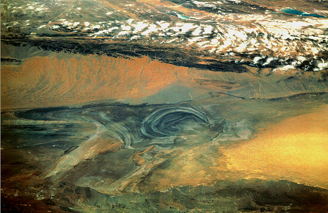
English: China, Xinjiang, desert Lop Nur. Satellite picture of the Basin of the formerly sea Lop Nur in the Desert of Lop. In the foreground Kuruktagh, in the background Kumtagh and Astintagh. A duststorm is blowing to the west over the Desert of Lop. Two lakes appear in a break in the clouds covering the Plateau of Astintagh. Visible are elongated Ayakkum Hu Lake south-southwest of Lop Nur and small blue-green Gas Hu Lake.
Deutsch: China, Xinjiang, Wüste Lop Nor. Satellitenaufnahme von dem mittleren Teil des Seebeckens Lop Nor und der Wüste Lop Nor, über die ein Sandsturm hinweggeht. Im Vordergrund sieht man die Hänge des Gebirges Kuruktagh, im Hintergrund die Hänge des Kumtagh und die Hochebene des Astintagh, auf der rechts der See Ayakkum Hu und links der kleinere See Gas Hu liegen. Blick von Norden Richtung Süden. |
| تاریخ | |
| منبع | NASA Mission: STS047, Roll-Frame 151 – 26, File name STS047-151-26.JPG. [1]. See also: [2]. |
| پدیدآور |
English: NASA. Image courtesy of Earth Sciences and Image Analysis Laboratory, NASA Johnson Space Center. Color adjusting of this image (using Adobe Photoshop 6.0): Michael Gaebler, 02. March 2006, own work, all rights released (Public domain).
Deutsch: Zugrunde liegt ein noch nicht farbrichtiges Astronauten-Foto der NASA. Diese Fotografie wurde von Michael Gaebler am 02. März 2006 im RGB-Modus mit Adobe Photoshop 6.0 mit Farb- und Tonwertkorrekturen überarbeitet. |
| اجازهنامه (استفادهٔ مجدد از این پرونده) |
PD-USGov-NASA |
![[1]](ftp://eol.jsc.nasa.gov/EFS_highres_STS047_STS047-151-26.JPG)
این نگاره یا ویدیو توسط یکی از مراکز سازمان ملی هوانوردی و فضایی (NASA)ایالات متحدهٔ آمریکا تحت شناسهٔ عکس: STS047-151-26کاتالوگ شدهاست. این برچست وضعیت حق تکثیر اثر ضمیمه شده را مشخص نمیکند. یک برچسپ معمولی همچنان مورد نیاز است. Commons:Licensing را برای کسب اطلاعات مشاهده فرمایید. زبانهای دیگر:
|
اجازهنامه
| این پرونده در مالکیت عمومی قرار دارد چرا که توسط ناسا ایجاد شده است. سیاست حق تکثیر ناسا بیان میکند که «مواد ناسا با حق تکثیر محافظت نمیشوند، مگراینکه ذکر شده باشد». (Template:PD-USGov، صفحهٔ سیاست حق تکثیر ناسا یا سیاست جیپیال استفاده از تصاویر را ببینید.) | ||
 |
هشدارها:
|
تاریخچهٔ پرونده
روی تاریخ/زمانها کلیک کنید تا نسخهٔ مربوط به آن هنگام را ببینید.
| تاریخ/زمان | بندانگشتی | ابعاد | کاربر | توضیح | |
|---|---|---|---|---|---|
| کنونی | ۱۰ مارس ۲۰۰۶، ساعت ۲۲:۴۶ | | ۲٬۵۳۹ در ۱٬۶۵۱ (۲٫۵ مگابایت) | Michael Gäbler | {{Information| |Description = en: China, Xinjiang, desert Lop Nur. Satellite picture of the Basin of the formerly sea Lop Nur in the Desert of Lop. In the foreground Kuruktagh, in the background Kumtagh and Astintagh. A duststorm is blowing to th |
کاربرد پرونده
صفحهٔ زیر از این تصویر استفاده میکند:
کاربرد سراسری پرونده
ویکیهای دیگر زیر از این پرونده استفاده میکنند:
- کاربرد در az.wikipedia.org
- کاربرد در de.wikipedia.org
- کاربرد در en.wikipedia.org
- کاربرد در en.wikibooks.org
- کاربرد در es.wikipedia.org
- کاربرد در frr.wikipedia.org
- کاربرد در he.wikivoyage.org
- کاربرد در hi.wikipedia.org
- کاربرد در id.wikipedia.org
- کاربرد در it.wikipedia.org
- کاربرد در ja.wikipedia.org
- کاربرد در ka.wikipedia.org
- کاربرد در ko.wikipedia.org
- کاربرد در mn.wikipedia.org
- کاربرد در pa.wikipedia.org
- کاربرد در pl.wikipedia.org
- کاربرد در pnb.wikipedia.org
- کاربرد در ro.wikipedia.org
- کاربرد در sh.wikipedia.org
- کاربرد در sl.wikipedia.org
- کاربرد در sr.wikipedia.org
- کاربرد در sv.wikipedia.org
- کاربرد در te.wikipedia.org
- کاربرد در tr.wikipedia.org
- کاربرد در ug.wikipedia.org
- کاربرد در uk.wikipedia.org
- کاربرد در ur.wikipedia.org
- کاربرد در www.wikidata.org
- کاربرد در zh.wikipedia.org