پرونده:China-Gansu.png
تفکیکپذیری بالاتری در دسترس نیست.
China-Gansu.png (۲۶۸ × ۲۱۸ پیکسل، اندازهٔ پرونده: ۱۶ کیلوبایت، نوع MIME پرونده: image/png)
این پرونده در ویکیانبار موجود است. محتویات صفحهٔ توصیف آن در زیر نمایش داده میشود. |
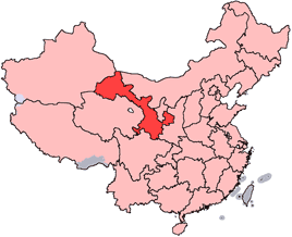
en: Location of Gansu Province in the People's Republic of China. See Locator maps of province-level divisions of the People's Republic of China for more information.
zh: 甘肅省在中華人民共和國的位置。另見Locator maps of province-level divisions of the People's Republic of China。

|
اجازهٔ کپی، پخش و/یا تغییر این سند تحت شرایط مجوز مستندات آزاد گنو، نسخهٔ ۱٫۲ یا هر نسخهٔ بعدتری که توسط بنیاد نرمافزار آزاد منتشر شده؛ بدون بخشهای ناوردا (نامتغیر)، متون روی جلد، و متون پشت جلد، اعطا میشود. یک کپی از مجوز در بخشی تحت عنوان مجوز مستندات آزاد گنو ضمیمه شده است. |
| این پرونده با اجازهنامهٔ کریتیو کامانز Attribution-Share Alike 3.0 سازگار نشده منتشر شده است. | ||
| ||
| این برچسب مجوز بهعنوان بخشی از روزآمدسازی مجوز GFDL، به این پرونده افزوده شد. |

|
File:Map of PRC Gansu.svg یک نسخهٔ برداری از این پرونده است.
آن پرونده را هنگامی که بهتر بود میبایست به جای این نسخهٔ تصویر استفاده کرد. File:China-Gansu.png → File:Map of PRC Gansu.svg
برای کسب اطلاعات بیشتر در ارتباط با تصاویر برداری لطفاً اینجا را مطالعهکنید. همچنین اطلاعات بیشتری در ارتباط با حمایت مدیاویکی از تصاویر اسویجی وجود دارد. |
 |
تاریخچهٔ پرونده
روی تاریخ/زمانها کلیک کنید تا نسخهٔ مربوط به آن هنگام را ببینید.
| تاریخ/زمان | بندانگشتی | ابعاد | کاربر | توضیح | |
|---|---|---|---|---|---|
| کنونی | ۱۵ ژوئیهٔ ۲۰۰۵، ساعت ۱۴:۵۶ | | ۲۶۸ در ۲۱۸ (۱۶ کیلوبایت) | Schaengel89~commonswiki | transparent background |
| ۴ ژوئن ۲۰۰۵، ساعت ۲۲:۳۹ |  | ۲۶۸ در ۲۱۸ (۹ کیلوبایت) | Ran | '''en''': Location of Gansu Province in the People's Republic of China. See Category:Locator maps of province-level divisions of the People's Republic of China for more information. '''zh''': 甘肅省在中華人民共和國的位置。另見[[:Cat |
کاربرد پرونده
این پرونده در هیچ صفحهای به کار نرفته است.
کاربرد سراسری پرونده
ویکیهای دیگر زیر از این پرونده استفاده میکنند:
- کاربرد در bn.wikipedia.org
- کاربرد در da.wikipedia.org
- کاربرد در de.wikipedia.org
- کاربرد در en.wikipedia.org
- Wikipedia:WikiProject Chinese provinces/Locator maps
- Xiahe County
- Yongjing County
- Daxia River
- Kongtong Mountains
- Subei Mongol Autonomous County
- Bairi Tibetan Autonomous County
- Zhuanglang County
- Huangyangchuan
- User:OldakQuill/temp
- Dunhuang Mogao International Airport
- Yongchang County
- Qingyang Airport
- Template:Gansu-geo-stub
- Xifeng, Qingyang
- Mazong Mountain
- Liancheng National Nature Reserve
- Longxi County
- Lintao County
- Min County
- Wushao Mountain
- 2008 Tibetan unrest
- Chongxin County
- Guanghe County
- Hezheng County
- Dongxiang Autonomous County
- Xihe County
- Wushan County, Gansu
- Qingshui County
- Qin'an County
- Gangu County
- Zhangjiachuan Hui Autonomous County
- Qinzhou, Tianshui
- Maiji, Tianshui
نمایش استفادههای سراسری از این پرونده.