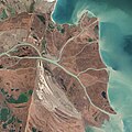
پرونده:Danubedelta chilia lobe satellite image.jpg

اندازهٔ این پیشنمایش: ۶۰۰ × ۶۰۰ پیکسل. کیفیتهای دیگر: ۲۴۰ × ۲۴۰ پیکسل | ۴۸۰ × ۴۸۰ پیکسل | ۷۶۸ × ۷۶۸ پیکسل | ۱٬۰۲۴ × ۱٬۰۲۴ پیکسل | ۲٬۰۴۸ × ۲٬۰۴۸ پیکسل | ۳٬۶۷۹ × ۳٬۶۷۹ پیکسل.
پروندهٔ اصلی (۳٬۶۷۹ × ۳٬۶۷۹ پیکسل، اندازهٔ پرونده: ۳٫۹۵ مگابایت، نوع MIME پرونده: image/jpeg)
تاریخچهٔ پرونده
روی تاریخ/زمانها کلیک کنید تا نسخهٔ مربوط به آن هنگام را ببینید.
| تاریخ/زمان | بندانگشتی | ابعاد | کاربر | توضیح | |
|---|---|---|---|---|---|
| کنونی | ۴ ژوئیهٔ ۲۰۱۴، ساعت ۲۲:۱۰ |  | ۳٬۶۷۹ در ۳٬۶۷۹ (۳٫۹۵ مگابایت) | Gretarsson | {{Information |Description ={{en|1=Original image caption (excerpt): The image above was acquired on February 5, 2013, by the Advanced Land Imager (ALI) on NASA’s Earth Observing-1 (EO-1) satellite. The Danube Delta has a number of lobes formed ov... |
کاربرد پرونده
صفحهٔ زیر از این تصویر استفاده میکند:
کاربرد سراسری پرونده
ویکیهای دیگر زیر از این پرونده استفاده میکنند:
- کاربرد در cy.wikipedia.org
- کاربرد در da.wikipedia.org
- کاربرد در de.wikipedia.org
- کاربرد در fi.wikipedia.org
- کاربرد در ja.wikipedia.org
- کاربرد در mk.wikipedia.org
- کاربرد در ru.wikipedia.org
- کاربرد در sl.wikipedia.org
- کاربرد در ta.wikipedia.org
- کاربرد در th.wikipedia.org
- کاربرد در uk.wikipedia.org
- کاربرد در vi.wikipedia.org

