پرونده:Enchanted rock 2006.jpg
تفکیکپذیری بالاتری در دسترس نیست.
Enchanted_rock_2006.jpg (۶۴۰ × ۴۸۰ پیکسل، اندازهٔ پرونده: ۵۹ کیلوبایت، نوع MIME پرونده: image/jpeg)
این پرونده در ویکیانبار موجود است. محتویات صفحهٔ توصیف آن در زیر نمایش داده میشود. |
خلاصه
|
This is an image of a place or building that is listed on the National Register of Historic Places in the United States of America. Its reference number is 84001740. |
| توضیح |
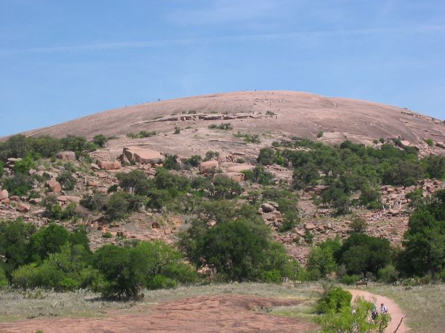
Enchanted Rock as viewed from the trail leading to the summit. People climbing on the summit (visible as dots) give an idea of the scale of the granite rock. Source: Photo taken by uploader, April 14, 2006. |
| تاریخ | ۱۸ آوریل ۲۰۰۶ (تاریخ اصلی بارگذاری) |
| منبع | Transferred from en.wikipedia to Commons. |
| پدیدآور | Claygate در ویکیپدیا انگلیسی |
| مختصات شیء | | محل قرارگیری این نگاره و سایر نگارهها در: نقشهٔ شهری باز |
|---|
اجازهنامه
| این اثر توسط پدیدآور آن، Claygate در ویکیپدیا انگلیسی، به مالکیت عمومی درآمده است. این مربوط به تمام جهان است. در برخی از کشورها ممکن است به صورت قانونی این امکانپذیر نباشد؛ اگر چنین است: Claygate به هر کسی اجازهٔ استفاده از این اثر برای هر مقصودی، بدون هیچگونه شرایطی، را میدهد تا وقتی که این شرایط توسط قانون مستلزم نشده باشند. |
سیاهه بارگذاری اصلی
صفحهٔ اصلی توضیحات اینجابود. همهٔ نامهای کاربر زیر به en.wikipedia اشاره دارند.
- 2006-04-18 01:13 Claygate 640×480×8 (60062 bytes) Picture taken by uploader, April 14, 2006.
تاریخچهٔ پرونده
روی تاریخ/زمانها کلیک کنید تا نسخهٔ مربوط به آن هنگام را ببینید.
| تاریخ/زمان | بندانگشتی | ابعاد | کاربر | توضیح | |
|---|---|---|---|---|---|
| کنونی | ۲۴ آوریل ۲۰۰۷، ساعت ۰۲:۰۴ | | ۶۴۰ در ۴۸۰ (۵۹ کیلوبایت) | Jomegat | {{Information |Description=Enchanted Rock as viewed from the trail leading to the summit. People climbing on the summit (visible as dots) give an idea of the scale of the granite rock. Source: Photo taken by uploader, April 14, 2006. |Source=Originally f |
کاربرد پرونده
صفحهٔ زیر از این تصویر استفاده میکند:
کاربرد سراسری پرونده
ویکیهای دیگر زیر از این پرونده استفاده میکنند:
- کاربرد در de.wikipedia.org
- کاربرد در en.wikipedia.org
- Llano, Texas
- Llano Uplift
- Enchanted Rock
- List of Texas state parks
- List of National Natural Landmarks in Texas
- National Register of Historic Places listings in Gillespie County, Texas
- National Register of Historic Places listings in Llano County, Texas
- National Register of Historic Places listings in the Alamo region of Texas: Other
- National Register of Historic Places listings in the Capital region of Texas: Other
- کاربرد در en.wikibooks.org
- کاربرد در es.wikipedia.org
- کاربرد در fr.wikipedia.org
- کاربرد در it.wikipedia.org
- کاربرد در nl.wikipedia.org
- کاربرد در sv.wikipedia.org
- کاربرد در zh.wikipedia.org