پرونده:FCA airport map.gif

اندازهٔ این پیشنمایش: ۳۹۰ × ۵۹۹ پیکسل. کیفیتهای دیگر: ۱۵۶ × ۲۴۰ پیکسل | ۳۱۲ × ۴۸۰ پیکسل | ۸۰۵ × ۱٬۲۳۷ پیکسل.
پروندهٔ اصلی (۸۰۵ × ۱٬۲۳۷ پیکسل، اندازهٔ پرونده: ۵۵ کیلوبایت، نوع MIME پرونده: image/gif)
این پرونده در ویکیانبار موجود است. محتویات صفحهٔ توصیف آن در زیر نمایش داده میشود. |
خلاصه
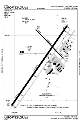
FAA Diagram of Glacier Park International Airport (GPI, formerly FCA) in Montana.
Produced by the National Aeronautical Charting Office (NACO), a department of the Federal Aviation Administration (FAA).
http://naco.faa.gov/d-tpp/0606/00887AD.PDF
Note: this URL changes monthly, for current diagram see: Template:FAA-diagram.
اجازهنامه
This image or file is a work of a Federal Aviation Administration employee, taken or made as part of that person's official duties. As a work of the U.S. federal government, the image is in the public domain in the United States.
|
 |
تاریخچهٔ پرونده
روی تاریخ/زمانها کلیک کنید تا نسخهٔ مربوط به آن هنگام را ببینید.
| تاریخ/زمان | بندانگشتی | ابعاد | کاربر | توضیح | |
|---|---|---|---|---|---|
| کنونی | ۳ ژوئن ۲۰۰۷، ساعت ۰۳:۲۳ | | ۸۰۵ در ۱٬۲۳۷ (۵۵ کیلوبایت) | Julius Morton | ==Summary== FAA Diagram of Glacier Park International Airport (GPI, formerly FCA) in Montana. Produced by the National Aeronautical Charting Office (NACO), a department of the Federal Aviation Administration (FAA). http://naco.faa.gov/d-tpp/0606 |
کاربرد پرونده
صفحهٔ زیر از این تصویر استفاده میکند:
کاربرد سراسری پرونده
ویکیهای دیگر زیر از این پرونده استفاده میکنند:
- کاربرد در en.wikipedia.org
- کاربرد در es.wikipedia.org
- کاربرد در id.wikipedia.org
- کاربرد در tg.wikipedia.org
- کاربرد در ur.wikipedia.org