پرونده:FRONT (SOUTH) AND WEST SIDE - Nelias Fall House, County Road 96 (Old Saint Stephens Road), Mount Vernon, Mobile County, HABS ALA,49-MOUV,5-1.tif

حجم پیشنمایش JPG این TIF file:۸۰۰ × ۵۷۴ پیکسل کیفیتهای دیگر: ۳۲۰ × ۲۳۰ پیکسل | ۶۴۰ × ۴۵۹ پیکسل | ۱٬۰۲۴ × ۷۳۵ پیکسل | ۱٬۲۸۰ × ۹۱۹ پیکسل | ۲٬۵۶۰ × ۱٬۸۳۷ پیکسل | ۵٬۰۰۰ × ۳٬۵۸۸ پیکسل.
پروندهٔ اصلی (۵٬۰۰۰ × ۳٬۵۸۸ پیکسل، اندازهٔ پرونده: ۱۷٫۱۱ مگابایت، نوع MIME پرونده: image/tiff)
این پرونده در ویکیانبار موجود است. محتویات صفحهٔ توصیف آن در زیر نمایش داده میشود. |
خلاصه
| Historic American Buildings Survey E. W. Russell, Photographer, January 8, 1937 FRONT (SOUTH) AND WEST SIDE - Nelias Fall House, County Road 96 (Old Saint Stephens Road), Mount Vernon, Mobile County, AL | ||||
|---|---|---|---|---|
| عنوان |
Historic American Buildings Survey E. W. Russell, Photographer, January 8, 1937 FRONT (SOUTH) AND WEST SIDE - Nelias Fall House, County Road 96 (Old Saint Stephens Road), Mount Vernon, Mobile County, AL |
|||
| محل کشیدهشده | Alabama; Mobile County; Mount Vernon | |||
| تاریخ | Documentation compiled after 1933 | |||
| تکنیک/سبک | 5 x 7 in. | |||
| مکان کنونی |
Library of Congress Prints and Photographs Division Washington, D.C. 20540 USA http://hdl.loc.gov/loc.pnp/pp.print |
|||
| آیدی |
HABS ALA,49-MOUV,5-1 |
|||
| خط اعتبار |
|
|||
| یادداشتها |
|
|||
| منبع | https://www.loc.gov/pictures/item/al0386.photos.005709p | |||
| اجازهنامه (استفادهٔ مجدد از این پرونده) |
|
|||

| مختصات شیء | | محل قرارگیری این نگاره و سایر نگارهها در: نقشهٔ شهری باز |
|---|
تاریخچهٔ پرونده
روی تاریخ/زمانها کلیک کنید تا نسخهٔ مربوط به آن هنگام را ببینید.
| تاریخ/زمان | بندانگشتی | ابعاد | کاربر | توضیح | |
|---|---|---|---|---|---|
| کنونی | ۲۹ ژوئن ۲۰۱۴، ساعت ۱۰:۰۲ | 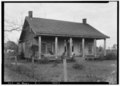 | ۵٬۰۰۰ در ۳٬۵۸۸ (۱۷٫۱۱ مگابایت) | Fæ | GWToolset: Creating mediafile for Fæ. HABS batch upload restart 26 June 2014 (p21:101)x |
کاربرد پرونده
صفحهٔ زیر از این تصویر استفاده میکند:
کاربرد سراسری پرونده
ویکیهای دیگر زیر از این پرونده استفاده میکنند:
- کاربرد در ar.wikipedia.org
- کاربرد در en.wikipedia.org
- کاربرد در fr.wikipedia.org