پرونده:FRONT VIEW. - Lewis McMillan House, County Road 31, Orrville, Dallas County, AL HABS ALA,24- ,3-1.tif

حجم پیشنمایش JPG این TIF file:۸۰۰ × ۵۶۹ پیکسل کیفیتهای دیگر: ۳۲۰ × ۲۲۸ پیکسل | ۶۴۰ × ۴۵۵ پیکسل | ۱٬۰۲۴ × ۷۲۸ پیکسل | ۱٬۲۸۰ × ۹۱۰ پیکسل | ۲٬۵۶۰ × ۱٬۸۲۱ پیکسل | ۵٬۰۰۰ × ۳٬۵۵۶ پیکسل.
پروندهٔ اصلی (۵٬۰۰۰ × ۳٬۵۵۶ پیکسل، اندازهٔ پرونده: ۱۶٫۹۶ مگابایت، نوع MIME پرونده: image/tiff)
این پرونده در ویکیانبار موجود است. محتویات صفحهٔ توصیف آن در زیر نمایش داده میشود. |
خلاصه
| Historic American Buildings Survey W. N. Manning, Photographer, March 23, 1934. FRONT VIEW. - Lewis McMillan House, County Road 31, Orrville, Dallas County, AL | ||||
|---|---|---|---|---|
| عنوان |
Historic American Buildings Survey W. N. Manning, Photographer, March 23, 1934. FRONT VIEW. - Lewis McMillan House, County Road 31, Orrville, Dallas County, AL |
|||
| محل تصویرشده | Alabama; Dallas County; Orrville | |||
| تاریخ | Documentation compiled after 1933 | |||
| تکنیک/سبک | 5 x 7 in. | |||
| مکان کنونی |
Library of Congress Prints and Photographs Division Washington, D.C. 20540 USA http://hdl.loc.gov/loc.pnp/pp.print |
|||
| آیدی |
HABS ALA,24-____,3-1 |
|||
| خط اعتبار |
|
|||
| یادداشتها |
|
|||
| منبع | https://www.loc.gov/pictures/item/al0127.photos.002067p | |||
| اجازهنامه (استفادهٔ مجدد از این پرونده) |
|
|||

| مختصات شیء | | محل قرارگیری این نگاره و سایر نگارهها در: نقشهٔ شهری باز |
|---|
تاریخچهٔ پرونده
روی تاریخ/زمانها کلیک کنید تا نسخهٔ مربوط به آن هنگام را ببینید.
| تاریخ/زمان | بندانگشتی | ابعاد | کاربر | توضیح | |
|---|---|---|---|---|---|
| کنونی | ۲۷ ژوئن ۲۰۱۴، ساعت ۱۸:۰۱ | 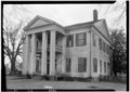 | ۵٬۰۰۰ در ۳٬۵۵۶ (۱۶٫۹۶ مگابایت) | Fæ | GWToolset: Creating mediafile for Fæ. HABS batch upload restart 26 June 2014 (p21:101)x |
کاربرد پرونده
صفحهٔ زیر از این تصویر استفاده میکند:
کاربرد سراسری پرونده
ویکیهای دیگر زیر از این پرونده استفاده میکنند:
- کاربرد در en.wikipedia.org