پرونده:Hindoostan map 1831.jpg

پروندهٔ اصلی (۲٬۶۷۶ × ۳٬۵۱۰ پیکسل، اندازهٔ پرونده: ۲٫۳۶ مگابایت، نوع MIME پرونده: image/jpeg)
این پرونده در ویکیانبار موجود است. محتویات صفحهٔ توصیف آن در زیر نمایش داده میشود. |
خلاصه
| Description |
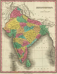
Map of Hindostan or India (1831) by Anthony Finley |
|||||||||
| تاریخ | ||||||||||
| منبع | David Rumsey Collection of Historic Maps The link to the source is here | |||||||||
| پدیدآورنده |
Anthony Finley |
|||||||||
| Geotemporal data | ||||||||||
| Bounding box |
|
|||||||||
| Georeferencing | ||||||||||
اجازهنامه
|
این اثر در کشورهایی و مناطقی که مدت زمان حق تکثیر، عمر پدیدآورنده بعلاوه 70 سال یا کمتر بعد از مرگ او است، در مالکیت عمومی قرار دارد.
| |
| این پرونده تحت قانون حق تکثیر محدودیت آزاد منتشر شده که شامل تمامی حقوق مربوطه و حقوق نزدیک به آن میشود. | |
|
این اثر در کشورهایی و مناطقی که مدت زمان حق تکثیر، عمر پدیدآورنده بعلاوه 100 سال یا کمتر بعد از مرگ او است، در مالکیت عمومی قرار دارد. این اثر در ایالات متحده آمریکا در مالکیت عمومی قرار دارد به این دلیل که قبل از ۱ ژانویهٔ ۱۹۲۹ منتشر یا در ادارهٔ حق تکثیر آمریکا ثبت شدهاست. | |
| این پرونده تحت قانون حق تکثیر محدودیت آزاد منتشر شده که شامل تمامی حقوق مربوطه و حقوق نزدیک به آن میشود. | |
تاریخچهٔ پرونده
روی تاریخ/زمانها کلیک کنید تا نسخهٔ مربوط به آن هنگام را ببینید.
| تاریخ/زمان | بندانگشتی | ابعاد | کاربر | توضیح | |
|---|---|---|---|---|---|
| کنونی | ۳۰ مارس ۲۰۰۷، ساعت ۱۵:۳۰ | | ۲٬۶۷۶ در ۳٬۵۱۰ (۲٫۳۶ مگابایت) | Planemad | ==Description== * Map of Hindostan or India (1831) by Anthony Finley from the [http://www.davidrumsey.com/ David Rumsey Collection of Historic Maps] ==Source== http://recall.curtin.edu.au/ecai/historic%20maps.htm ==License== {{cc-by-sa 2.0}} {{PD-old}} |
کاربرد پرونده
صفحهٔ زیر از این تصویر استفاده میکند:
کاربرد سراسری پرونده
ویکیهای دیگر زیر از این پرونده استفاده میکنند:
- کاربرد در be-tarask.wikipedia.org
- کاربرد در de.wikipedia.org
- کاربرد در el.wikipedia.org
- کاربرد در en.wikipedia.org
- کاربرد در ja.wikipedia.org
- کاربرد در ko.wikipedia.org
- کاربرد در lt.wikipedia.org
- کاربرد در pnb.wikipedia.org
- کاربرد در ps.wikipedia.org
- کاربرد در ur.wikipedia.org
- کاربرد در vi.wikipedia.org