پرونده:Kabardino-balkaria map.png
تفکیکپذیری بالاتری در دسترس نیست.
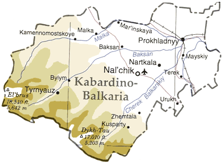
Kabardino-balkaria_map.png (۴۵۰ × ۳۲۹ پیکسل، اندازهٔ پرونده: ۳۳ کیلوبایت، نوع MIME پرونده: image/png)
این پرونده در ویکیانبار موجود است. محتویات صفحهٔ توصیف آن در زیر نمایش داده میشود. |
| توضیح |
Map of en:Kabardino-Balkaria, en:Russia en:Category:Caucasus maps en:Category:Maps of the Russian republics |
|||
| منبع | Adapted from "The Caucasus Region" map, US Dept of State [1] | |||
| پدیدآور | User ChrisO on en.wikipedia (uploaded to commons by User:StYxXx) | |||
| اجازهنامه (استفادهٔ مجدد از این پرونده) |
|
|||
| دیگر نسخهها |
آثار انشقاقی از این پرونده: Originally from en.wikipedia; description page is (was) here {{Information |Description=The cooling towers of [[Stella power station]]. |Source=Scanned black and white print |Date=1990 |Author=Aidan Doyle }}{{Information |Description=The cooling towers of [[Stella power station]]. |Source=Scanned black and white print |Date=1990 |Author=Aidan Doyle }}••••••••••••••• |

![[1]](http://www.lib.utexas.edu/maps/commonwealth/caucasus_region_1994.jpg)
(Uploaded using CommonsHelper or PushForCommons)
تاریخچهٔ پرونده
روی تاریخ/زمانها کلیک کنید تا نسخهٔ مربوط به آن هنگام را ببینید.
| تاریخ/زمان | بندانگشتی | ابعاد | کاربر | توضیح | |
|---|---|---|---|---|---|
| کنونی | ۱۲ نوامبر ۲۰۰۶، ساعت ۱۹:۴۵ | | ۴۵۰ در ۳۲۹ (۳۳ کیلوبایت) | StYxXx | {{Information| |Description= Map of en:Kabardino-Balkaria, en:Russia Adapted from "The Caucasus Region" map, US Dept of State [http://www.lib.utexas.edu/maps/commonwealth/caucasus_region_1994.jpg] en:Category:Caucasus maps [[:en:Category: |
کاربرد پرونده
صفحهٔ زیر از این تصویر استفاده میکند:
کاربرد سراسری پرونده
ویکیهای دیگر زیر از این پرونده استفاده میکنند:
- کاربرد در ar.wikipedia.org
- کاربرد در ast.wikipedia.org
- کاربرد در ceb.wikipedia.org
- کاربرد در cy.wikipedia.org
- کاربرد در da.wikipedia.org
- کاربرد در de.wikipedia.org
- کاربرد در el.wikipedia.org
- کاربرد در en.wikipedia.org
- کاربرد در eo.wikipedia.org
- کاربرد در es.wikipedia.org
- کاربرد در eu.wikipedia.org
- کاربرد در fi.wikipedia.org
- کاربرد در fr.wikipedia.org
- کاربرد در gag.wikipedia.org
- کاربرد در hu.wikipedia.org
- کاربرد در ko.wikipedia.org
- کاربرد در nl.wikipedia.org
- کاربرد در nn.wikipedia.org
- کاربرد در pl.wikipedia.org
- کاربرد در sah.wikipedia.org
- کاربرد در sr.wikipedia.org
- کاربرد در tr.wikipedia.org
- کاربرد در uk.wikipedia.org
- کاربرد در www.wikidata.org