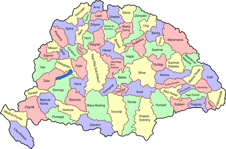
پرونده:Kingdom of Hungary counties-2.svg

حجم پیشنمایش PNG این SVG file:۷۷۹ × ۵۱۳ پیکسل کیفیتهای دیگر: ۳۲۰ × ۲۱۱ پیکسل | ۶۴۰ × ۴۲۱ پیکسل | ۱٬۰۲۴ × ۶۷۴ پیکسل | ۱٬۲۸۰ × ۸۴۳ پیکسل | ۲٬۵۶۰ × ۱٬۶۸۶ پیکسل.
پروندهٔ اصلی (پروندهٔ اسویجی، با ابعاد ۷۷۹ × ۵۱۳ پیکسل، اندازهٔ پرونده: ۲۶۵ کیلوبایت)
تاریخچهٔ پرونده
روی تاریخ/زمانها کلیک کنید تا نسخهٔ مربوط به آن هنگام را ببینید.
| تاریخ/زمان | بندانگشتی | ابعاد | کاربر | توضیح | |
|---|---|---|---|---|---|
| کنونی | ۵ دسامبر ۲۰۰۹، ساعت ۱۷:۵۷ |  | ۷۷۹ در ۵۱۳ (۲۶۵ کیلوبایت) | SimonTrew | I missed some fixes of Veszprém |
| ۵ دسامبر ۲۰۰۹، ساعت ۱۷:۵۵ |  | ۷۷۹ در ۵۱۳ (۲۶۵ کیلوبایت) | SimonTrew | Fix spelling of Vesprém, as I have just done on original. | |
| ۳ دسامبر ۲۰۰۹، ساعت ۱۴:۲۹ |  | ۷۷۹ در ۵۱۳ (۲۶۵ کیلوبایت) | SimonTrew | Fix spelling of Pozsony, as I have just done on original work | |
| ۳ دسامبر ۲۰۰۹، ساعت ۱۳:۳۷ |  | ۷۷۹ در ۵۱۳ (۲۶۵ کیلوبایت) | SimonTrew | Made four colour map. The text still only uses one style at the moment, this needs to be made to match the four styles used for the four colours for the counties, but this is easier to do once it is uploaded and I can print the png. Sorry if this is "not | |
| ۳ دسامبر ۲۰۰۹، ساعت ۱۱:۲۹ |  | ۷۷۹ در ۵۱۳ (۲۸۷ کیلوبایت) | SimonTrew | Fixed the few errors in borders, removed unnecessary style fields from text (Inkscape adds them but they are covered by other fields), text still needs doing better | |
| ۳ دسامبر ۲۰۰۹، ساعت ۰۱:۱۶ |  | ۷۷۹ در ۵۱۳ (۲۸۶ کیلوبایت) | SimonTrew | {{Information |Description=Map of counties of Kingdom of Hungary (Hungary proper and Croatia & Slavonia), 1886-1918. I have organised this into layers: Three layers of paths for the counties, for the county borders, and for external border. and one layer |
کاربرد پرونده
صفحهٔ زیر از این تصویر استفاده میکند:
کاربرد سراسری پرونده
ویکیهای دیگر زیر از این پرونده استفاده میکنند:
- کاربرد در ar.wikipedia.org
- کاربرد در bs.wikipedia.org
- کاربرد در ceb.wikipedia.org
- کاربرد در ckb.wikipedia.org
- کاربرد در da.wikipedia.org
- کاربرد در de.wikipedia.org
- کاربرد در en.wikipedia.org
- User talk:Random user 8384993
- Wikipedia talk:WikiProject Hungary/Archive 2
- Module:Location map/data/Kingdom of Hungary/doc
- Wikipedia:Redirects for discussion/Log/2015 April 19
- User:Drkazmer/Jewish centres in the Kingdom of Hungary
- Wikipedia:Graphics Lab/Map workshop/Archive/2017/Sep 2017
- Module:Location map/data/Kingdom of Hungary
- کاربرد در fr.wikipedia.org
- کاربرد در hu.wikipedia.org
- کاربرد در kn.wikipedia.org
- کاربرد در pt.wikipedia.org
- کاربرد در rue.wikipedia.org
- کاربرد در si.wikipedia.org
- کاربرد در sr.wikipedia.org
- کاربرد در tg.wikipedia.org
- کاربرد در tr.wikipedia.org
- کاربرد در uz.wikipedia.org
- کاربرد در war.wikipedia.org
