پرونده:Lake Athabasca, Canada.jpg

اندازهٔ این پیشنمایش: ۸۰۰ × ۳۳۸ پیکسل. کیفیتهای دیگر: ۳۲۰ × ۱۳۵ پیکسل | ۶۴۰ × ۲۷۰ پیکسل | ۱٬۱۵۶ × ۴۸۸ پیکسل.
پروندهٔ اصلی (۱٬۱۵۶ × ۴۸۸ پیکسل، اندازهٔ پرونده: ۱۷۳ کیلوبایت، نوع MIME پرونده: image/jpeg)
این پرونده در ویکیانبار موجود است. محتویات صفحهٔ توصیف آن در زیر نمایش داده میشود. |
خلاصه
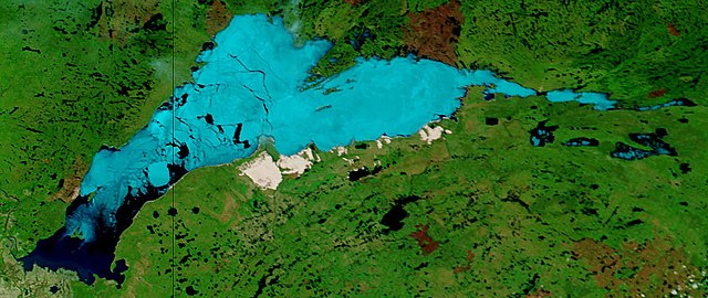
| توضیح | Lake Athabasca, Canada. Lake Athabasca straddles the border between Alberta (west) and Saskatchewan (east) - the black line. In the false-color image, vegetation is green, water is dark blue, and ice (or snow) is light blue. |
| تاریخ | Visualization Date: 2002-06-18 |
| منبع | Visible Earth, NASA (extract) |
| پدیدآور | Jacques Descloitres, MODIS Land Rapid Response Team, NASA/GSFC |
Cropped from the original 4800 x 3600 JPEG (4.4MB) image.
اجازهنامه
| این پرونده در مالکیت عمومی قرار دارد چرا که توسط ناسا ایجاد شده است. سیاست حق تکثیر ناسا بیان میکند که «مواد ناسا با حق تکثیر محافظت نمیشوند، مگراینکه ذکر شده باشد». (Template:PD-USGov، صفحهٔ سیاست حق تکثیر ناسا یا سیاست جیپیال استفاده از تصاویر را ببینید.) | ||
 |
هشدارها:
|
تاریخچهٔ پرونده
روی تاریخ/زمانها کلیک کنید تا نسخهٔ مربوط به آن هنگام را ببینید.
| تاریخ/زمان | بندانگشتی | ابعاد | کاربر | توضیح | |
|---|---|---|---|---|---|
| کنونی | ۱۸ اوت ۲۰۰۶، ساعت ۱۱:۳۷ | | ۱٬۱۵۶ در ۴۸۸ (۱۷۳ کیلوبایت) | Feydey | {{Information |Description= Lake Athabasca, Canada. Lake Athabasca straddles the border between Alberta (west) and Saskatchewan (east) - the black line. In the false-color image, vegetation is green, water is dark blue, and ice (or snow) is light blue. |S |
کاربرد پرونده
صفحهٔ زیر از این تصویر استفاده میکند:
کاربرد سراسری پرونده
ویکیهای دیگر زیر از این پرونده استفاده میکنند:
- کاربرد در af.wikipedia.org
- کاربرد در ar.wikipedia.org
- کاربرد در arz.wikipedia.org
- کاربرد در be.wikipedia.org
- کاربرد در bg.wikipedia.org
- کاربرد در bn.wikipedia.org
- کاربرد در bs.wikipedia.org
- کاربرد در ca.wikipedia.org
- کاربرد در ceb.wikipedia.org
- کاربرد در cv.wikipedia.org
- کاربرد در cy.wikipedia.org
- کاربرد در da.wikipedia.org
- کاربرد در el.wikipedia.org
- کاربرد در en.wikipedia.org
- کاربرد در eo.wikipedia.org
- کاربرد در es.wikipedia.org
- کاربرد در eu.wikipedia.org
- کاربرد در frr.wikipedia.org
- کاربرد در fr.wikipedia.org
- کاربرد در fy.wikipedia.org
- کاربرد در hu.wikipedia.org
- کاربرد در hy.wikipedia.org
- کاربرد در id.wikipedia.org
- کاربرد در incubator.wikimedia.org
- کاربرد در it.wikipedia.org
- کاربرد در ka.wikipedia.org
- کاربرد در kk.wikipedia.org
- کاربرد در ky.wikipedia.org
- کاربرد در lt.wikipedia.org
- کاربرد در lv.wikipedia.org
- کاربرد در nl.wikipedia.org
- کاربرد در no.wikipedia.org
- کاربرد در pl.wikipedia.org
- کاربرد در pl.wiktionary.org
- کاربرد در pnb.wikipedia.org
- کاربرد در pt.wikipedia.org
- کاربرد در ro.wikipedia.org
- کاربرد در ru.wikipedia.org
- کاربرد در sv.wikipedia.org
نمایش استفادههای سراسری از این پرونده.