پرونده:Lake Michigan bathymetry map.png
پروندهٔ اصلی (۵۹۷ × ۱٬۰۲۴ پیکسل، اندازهٔ پرونده: ۹۴۸ کیلوبایت، نوع MIME پرونده: image/png)
این پرونده در ویکیانبار موجود است. محتویات صفحهٔ توصیف آن در زیر نمایش داده میشود. |
خلاصه
| توضیح |
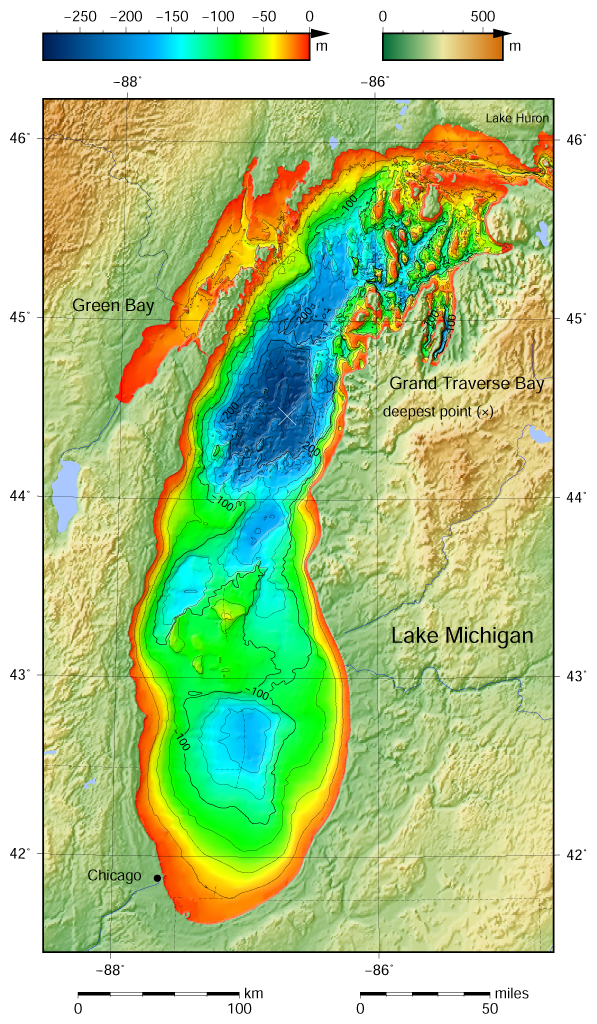
English: Lake Michigan bathymetric shaded relief map contoured with interval 25 m (100 m with thicker lines). The deepest point is marked with "×". For land the vertical datum is sea level, for bathymetry low water datum of the lake. The map was created using the Generic Mapping Tools, GMT, version 5.1.1. |
| تاریخ | |
| منبع |
Own work using: the following Public Domain datasets (grids):
The coordinates of deepest point are taken from the NOAA Great LakesEnvironmental Research Laboratory webpage (www.glerl.noaa.gov/, kml file Google Earth Great Lakes Tour). این نقشهٔ جهان با GMT ساخته شده است. |
| پدیدآور | Darekk2 using the Great Lakes Bathymetry and GLOBE tiles |
| دیگر نسخهها |
|

اجازهنامه
Attribution (in addition to the author of this map):
The NGDC in it's copyright notice says:
As required by 17 U.S.C. 403, third parties producing copyrighted works consisting predominantly of the material produced by U.S. government agencies must provide notice with such work(s) identifying the U.S. Government material incorporated and stating that such material is not subject to copyright protection within the United States. (...)
(for credits see the Source section).
and Great Lakes Bathymetry and GLOBE
(see above and the Source section)
- شما اجازه دارید:
- برای به اشتراک گذاشتن – برای کپی، توزیع و انتقال اثر
- تلفیق کردن – برای انطباق اثر
- تحت شرایط زیر:
- انتساب – شما باید اعتبار مربوطه را به دست آورید، پیوندی به مجوز ارائه دهید و نشان دهید که آیا تغییرات ایجاد شدهاند یا خیر. شما ممکن است این کار را به هر روش منطقی انجام دهید، اما نه به هر شیوهای که پیشنهاد میکند که مجوزدهنده از شما یا استفادهتان حمایت کند.
- انتشار مشابه – اگر این اثر را تلفیق یا تبدیل میکنید، یا بر پایه آن اثری دیگر خلق میکنید، میبایست مشارکتهای خود را تحت مجوز یکسان یا مشابه با ا اصل آن توزیع کنید.
تاریخچهٔ پرونده
روی تاریخ/زمانها کلیک کنید تا نسخهٔ مربوط به آن هنگام را ببینید.
| تاریخ/زمان | بندانگشتی | ابعاد | کاربر | توضیح | |
|---|---|---|---|---|---|
| کنونی | ۱۰ مهٔ ۲۰۱۵، ساعت ۱۲:۲۴ | | ۵۹۷ در ۱٬۰۲۴ (۹۴۸ کیلوبایت) | Darekk2 | a small island in NE |
| ۹ مهٔ ۲۰۱۵، ساعت ۱۶:۳۶ |  | ۵۹۷ در ۱٬۰۲۴ (۹۴۸ کیلوبایت) | Darekk2 | the lakes tiles better assembled, retouched western part of Green Bay | |
| ۹ آوریل ۲۰۱۵، ساعت ۲۲:۳۱ |  | ۵۹۷ در ۱٬۰۲۴ (۹۴۸ کیلوبایت) | Darekk2 | replaced contours generated by GMT program by contours downloaded from the NOAA website; added some annotations to contours; made contours 100 and 200 m bold; added rivers and minor lakes; moved Lake Michigan label and Chicago circle | |
| ۴ آوریل ۲۰۱۵، ساعت ۱۳:۲۹ |  | ۵۹۷ در ۱٬۰۲۴ (۹۴۲ کیلوبایت) | Darekk2 | User created page with UploadWizard |
کاربرد پرونده
صفحهٔ زیر از این تصویر استفاده میکند:
کاربرد سراسری پرونده
ویکیهای دیگر زیر از این پرونده استفاده میکنند:
- کاربرد در ban.wikipedia.org
- کاربرد در en.wikipedia.org
- کاربرد در hr.wikipedia.org
- کاربرد در kn.wikipedia.org
- کاربرد در ta.wikipedia.org
- کاربرد در vi.wikipedia.org
- کاربرد در www.wikidata.org