پرونده:Leland Michigan aerial view.jpg

اندازهٔ این پیشنمایش: ۸۰۰ × ۵۶۲ پیکسل. کیفیتهای دیگر: ۳۲۰ × ۲۲۵ پیکسل | ۶۴۰ × ۴۴۹ پیکسل | ۱٬۰۲۴ × ۷۱۹ پیکسل | ۱٬۲۸۰ × ۸۹۹ پیکسل | ۱٬۵۰۰ × ۱٬۰۵۳ پیکسل.
پروندهٔ اصلی (۱٬۵۰۰ × ۱٬۰۵۳ پیکسل، اندازهٔ پرونده: ۶۲۶ کیلوبایت، نوع MIME پرونده: image/jpeg)
این پرونده در ویکیانبار موجود است. محتویات صفحهٔ توصیف آن در زیر نمایش داده میشود. |
| توضیح |
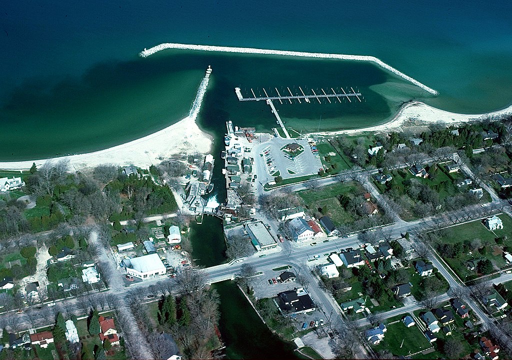
English: Aerial view of the shore and breakwater on Lake Michigan at Leland, Michigan, USA. The U.S. Army Corps of Engineers constructed the harbor and breakwater at the town. |
|||
| تاریخ | not specified or unknown | |||
| منبع |
U.S. Army Corps of Engineers Digital Visual Library Image page Image description page Digital Visual Library home page |
|||
| پدیدآور | U.S. Army Corps of Engineers, photographer not specified or unknown | |||
| اجازهنامه (استفادهٔ مجدد از این پرونده) |
|
|||
| مکان | Leland, Leelanau County, Michigan, USA |
| مختصات دوربین | | محل قرارگیری این نگاره و سایر نگارهها در: نقشهٔ شهری باز |
|---|
تاریخچهٔ پرونده
روی تاریخ/زمانها کلیک کنید تا نسخهٔ مربوط به آن هنگام را ببینید.
| تاریخ/زمان | بندانگشتی | ابعاد | کاربر | توضیح | |
|---|---|---|---|---|---|
| کنونی | ۲۹ مارس ۲۰۰۷، ساعت ۲۳:۵۸ | | ۱٬۵۰۰ در ۱٬۰۵۳ (۶۲۶ کیلوبایت) | DanMS | {{Information | Description = {{en|Aerial view of the shore and breakwater on Lake Michigan at Leland, Michigan, USA. The U.S. Army Corps of Engineers constructed the harbor and breakwater at the town.}} | Source = U.S. Army Corps of Engineers |
کاربرد پرونده
صفحهٔ زیر از این تصویر استفاده میکند:
کاربرد سراسری پرونده
ویکیهای دیگر زیر از این پرونده استفاده میکنند:
- کاربرد در azb.wikipedia.org
- کاربرد در ceb.wikipedia.org
- کاربرد در cy.wikipedia.org
- کاربرد در en.wikipedia.org
- کاربرد در en.wikivoyage.org
- کاربرد در es.wikipedia.org
- کاربرد در fr.wikipedia.org
- کاربرد در lld.wikipedia.org
- کاربرد در pl.wikipedia.org
- کاربرد در ro.wikipedia.org
- کاربرد در sh.wikipedia.org
- کاربرد در sr.wikipedia.org
- کاربرد در tt.wikipedia.org
- کاربرد در uk.wikipedia.org
- کاربرد در www.wikidata.org