پرونده:Location map United Kingdom City of Preston.svg

پروندهٔ اصلی (پروندهٔ اسویجی، با ابعاد ۱٬۱۸۷ × ۱٬۳۰۵ پیکسل، اندازهٔ پرونده: ۴٫۲۷ مگابایت)
این پرونده در ویکیانبار موجود است. محتویات صفحهٔ توصیف آن در زیر نمایش داده میشود. |
خلاصه
| توضیح |
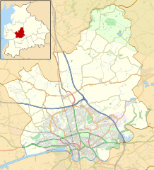
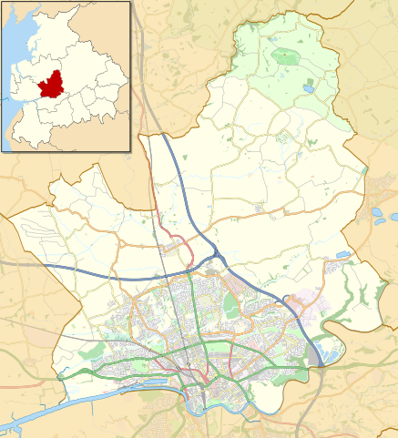
English: Map of the City of Preston district, Lancashire, England
Part of the Forest of Bowland Area of Outstanding Natural Beauty
Equirectangular map projection on WGS 84 datum, with N/S stretched 165% Geographic limits:
|
| تاریخ | Original version 2014-07-22 22:19 (UTC), updated 2018-04-07. |
| منبع |
این پرونده مشتق شدهاست از : |
| پدیدآور |
|

.svg)
اجازهنامه
| This work contains information from OpenStreetMap, which is made available under the Open Database License (ODbL).
The ODbL does not require any particular license for maps produced from ODbL data. Prior to 1 August 2020, map tiles produced by the OpenStreetMap Foundation were licensed under the CC-BY-SA-2.0 license. Maps produced by other people may be subject to other licences. |
- شما اجازه دارید:
- برای به اشتراک گذاشتن – برای کپی، توزیع و انتقال اثر
- تلفیق کردن – برای انطباق اثر
- تحت شرایط زیر:
- انتساب – شما باید اعتبار مربوطه را به دست آورید، پیوندی به مجوز ارائه دهید و نشان دهید که آیا تغییرات ایجاد شدهاند یا خیر. شما ممکن است این کار را به هر روش منطقی انجام دهید، اما نه به هر شیوهای که پیشنهاد میکند که مجوزدهنده از شما یا استفادهتان حمایت کند.
- انتشار مشابه – اگر این اثر را تلفیق یا تبدیل میکنید، یا بر پایه آن اثری دیگر خلق میکنید، میبایست مشارکتهای خود را تحت مجوز یکسان یا مشابه با ا اصل آن توزیع کنید.
سیاهه بارگذاری اصلی
This image is a derivative work of the following images:
- File:Preston_UK_ward_map_2010_(blank).svg licensed with Cc-by-sa-3.0
- 2011-04-24T22:48:11Z Nilfanion 1187x1305 (329725 Bytes) {{Information |Description=Map of Preston, Lancashire, UK with electoral wards shown. Equirectangular map projection on WGS 84 datum, with N/S stretched 165% Geographic limits: *West: 2.83W *East: 2.59W *North: 53.90N *Sout
Uploaded with derivativeFX
تاریخچهٔ پرونده
روی تاریخ/زمانها کلیک کنید تا نسخهٔ مربوط به آن هنگام را ببینید.
| تاریخ/زمان | بندانگشتی | ابعاد | کاربر | توضیح | |
|---|---|---|---|---|---|
| کنونی | ۷ آوریل ۲۰۱۸، ساعت ۱۹:۰۴ | | ۱٬۱۸۷ در ۱٬۳۰۵ (۴٫۲۷ مگابایت) | Dr Greg | Added Broughton bypass; adjusted some road colours for clarity |
| ۲۲ ژوئیهٔ ۲۰۱۴، ساعت ۲۱:۲۹ |  | ۱٬۱۸۷ در ۱٬۳۰۵ (۸٫۳۳ مگابایت) | Dr Greg | Add Forest of Bowland; remove some unnecessary details | |
| ۱۵ فوریهٔ ۲۰۱۳، ساعت ۲۱:۰۱ |  | ۱٬۱۸۷ در ۱٬۳۰۵ (۸٫۷۷ مگابایت) | Dr Greg | == {{int:filedesc}} == {{Information |Description= {{en|Map of Preston, Lancashire, UK with electoral wards shown. Equirectangular map projection on WGS 84 datum, with N/S stretched 165% Geographic limits: *West: 2.83W *East: 2.59W *North: 53.... |
کاربرد پرونده
صفحههای زیر از این تصویر استفاده میکنند:
کاربرد سراسری پرونده
ویکیهای دیگر زیر از این پرونده استفاده میکنند:
- کاربرد در ar.wikipedia.org
- کاربرد در azb.wikipedia.org
- کاربرد در ceb.wikipedia.org
- کاربرد در en.wikipedia.org
- Preston, Lancashire
- Catforth
- Goosnargh
- Grimsargh
- Barton, Preston
- Fulwood, Lancashire
- Woodplumpton
- Broughton, Lancashire
- Chingle Hall
- Lea, Lancashire
- Grimsargh railway station
- Whittingham, Lancashire
- Beacon Fell, Lancashire
- Inglewhite
- User:Dr Greg/Sandpit3
- RAF Barton Hall
- Haighton
- Whittingham Hospital
- Eaves, Lancashire
- Whitechapel, Lancashire
- Ingol
- HM Prison Preston
- Transport in Preston
- City of Preston, Lancashire
- Talk:City of Preston, Lancashire
- St Anne's Church, Woodplumpton
- St Mary's Church, Goosnargh
- St Michael's Church, Grimsargh
- St John the Baptist's Church, Broughton
- Module:Location map/data/United Kingdom City of Preston/doc
- Ye Horns Inn
- St Lawrence's Church, Barton
- St Mary's Church, Fernyhalgh
- Module:Location map/data/United Kingdom City of Preston
- The Plough at Eaves
- The Green Man at Inglewhite
- Barton and Broughton railway station
- Broughton railway station (England)
- کاربرد در ja.wikipedia.org
- کاربرد در kn.wikipedia.org
- کاربرد در si.wikipedia.org
- کاربرد در tr.wikipedia.org
- کاربرد در war.wikipedia.org