پرونده:MSH80 eruption mount st helens 05-18-80-dramatic-edit.jpg
اندازهٔ این پیشنمایش: ۳۹۹ × ۶۰۰ پیکسل. کیفیتهای دیگر: ۱۶۰ × ۲۴۰ پیکسل | ۳۱۹ × ۴۸۰ پیکسل | ۵۱۱ × ۷۶۸ پیکسل | ۶۸۱ × ۱٬۰۲۴ پیکسل | ۱٬۳۶۲ × ۲٬۰۴۸ پیکسل | ۲٬۹۹۴ × ۴٬۵۰۰ پیکسل.
پروندهٔ اصلی (۲٬۹۹۴ × ۴٬۵۰۰ پیکسل، اندازهٔ پرونده: ۲٫۱۴ مگابایت، نوع MIME پرونده: image/jpeg)
این پرونده در ویکیانبار موجود است. محتویات صفحهٔ توصیف آن در زیر نمایش داده میشود. |
| توضیح |
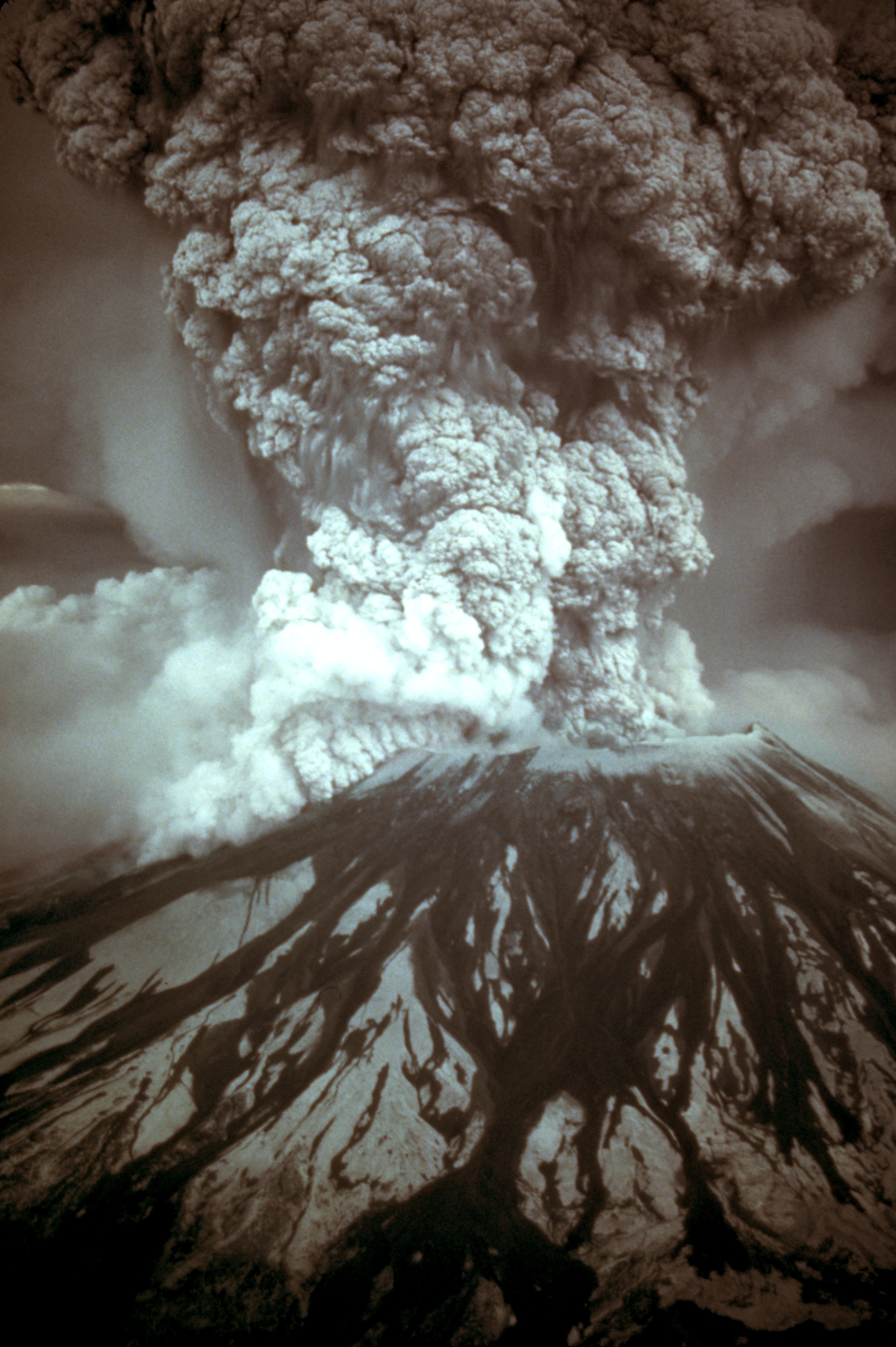
English: On May 18, 1980, at 8:32 a.m. Pacific Daylight Time, a magnitude 5.1 earthquake shook Mount St. Helens. The bulge and surrounding area slid away in a gigantic rockslide and debris avalanche, releasing pressure, and triggering a major pumice and ash eruption of the volcano. Thirteen-hundred feet (400 meters) of the peak collapsed or blew outwards. As a result, 24 square miles (62 square kilometers) of valley was filled by a debris avalanche, 250 square miles (650 square kilometers) of recreation, timber, and private lands were damaged by a lateral blast, and an estimated 200 million cubic yards (150 million cubic meters) of material was deposited directly by lahars (volcanic mudflows) into the river channels. Fifty-seven people were killed or are still missing.
USGS Photograph taken on May 18, 1980, by Austin Post.
Català: El 18 de maig, a les 8:32 a. m. Temps del Pacífic, un terratrèmol de una magnitud de 5,1 va fer trontollar la muntanya St. Helens. La protuberància l'àrea circumdant relliscà en una gegantina esllavissada de roques i un allau de rocam, alliberant la pressió, desencadenà una erupció de pedra tosca i cendra del volcà. 400 metres del puig van col·lapsar o van sortir volant. Com a resultat 62 quilometres quadrats de la vall van ser emplenats per la runa, 650 quilometres quadrats de llocs d'esbarjo, bosc, i finques privades van ser damnificades per una ràfega lateral, i una quantitat estimada en 150 milions de metres cúbics de material van ser dipositats per corrents de fang volcànic en els canals del riu. Cinquanta set persones van morir o han desaparegut (18 de Maig de 1980, Austin Post, USGS)
Español: Erupción del Monte Santa Helena el 18 de mayo de 1980. |
|||||||||||||
| تاریخ | ||||||||||||||
| منبع |
Huge tif converted to jpeg and caption from USGS Mount St. Helens, Washington May 18, 1980 Eruption Images |
|||||||||||||
| پدیدآور |
|
|||||||||||||
| اجازهنامه (استفادهٔ مجدد از این پرونده) |
|
|||||||||||||
| دیگر نسخهها |
 |
|||||||||||||
.jpg)
تاریخچهٔ پرونده
روی تاریخ/زمانها کلیک کنید تا نسخهٔ مربوط به آن هنگام را ببینید.
| تاریخ/زمان | بندانگشتی | ابعاد | کاربر | توضیح | |
|---|---|---|---|---|---|
| کنونی | ۲۸ نوامبر ۲۰۰۷، ساعت ۱۵:۱۷ | | ۲٬۹۹۴ در ۴٬۵۰۰ (۲٫۱۴ مگابایت) | CarolSpears | |
| ۲۸ نوامبر ۲۰۰۷، ساعت ۱۱:۴۱ |  | ۲٬۹۹۴ در ۴٬۵۰۰ (۱٫۹۲ مگابایت) | CarolSpears | {{Information |Description={{en|On May 18, 1980, at 8:32 a.m. Pacific Daylight Time, a magnitude 5.1 earthquake shook Mount St. Helens. The bulge and surrounding area slid away in a gigantic rockslide and debris avalanche, releasing pressure, and triggeri |
کاربرد پرونده
صفحههای زیر از این تصویر استفاده میکنند:
کاربرد سراسری پرونده
ویکیهای دیگر زیر از این پرونده استفاده میکنند:
- کاربرد در ar.wikipedia.org
- کاربرد در ast.wikipedia.org
- کاربرد در bg.wikipedia.org
- کاربرد در ca.wikipedia.org
- کاربرد در cs.wikipedia.org
- کاربرد در de.wikipedia.org
- کاربرد در el.wikipedia.org
- کاربرد در en.wikipedia.org
- 1980 eruption of Mount St. Helens
- May 1980
- Talk:Mount St. Helens/Archive 2
- Template:Infobox eruption
- Template:Infobox eruption/doc
- Wikipedia:Featured picture candidates/Mount St. Helens eruption
- Wikipedia:Featured picture candidates/June-2013
- Timeline of Washington (state) history
- Template:Infobox eruption/sandbox
- کاربرد در en.wiktionary.org
- کاربرد در es.wikipedia.org
- کاربرد در fi.wikipedia.org
- کاربرد در fr.wikipedia.org
- کاربرد در hr.wikipedia.org
- کاربرد در hu.wikipedia.org
- کاربرد در it.wikipedia.org
- کاربرد در it.wikiquote.org
- کاربرد در ja.wikipedia.org
- کاربرد در km.wikipedia.org
- کاربرد در kn.wikipedia.org
- کاربرد در ko.wikipedia.org
- کاربرد در mk.wikipedia.org
- کاربرد در ms.wikipedia.org
- کاربرد در mwl.wikipedia.org
نمایش استفادههای سراسری از این پرونده.