پرونده:NE AZ-NW NM NASA.jpg

پروندهٔ اصلی (۹۹۰ × ۸۳۰ پیکسل، اندازهٔ پرونده: ۶۴۵ کیلوبایت، نوع MIME پرونده: image/jpeg)
این پرونده در ویکیانبار موجود است. محتویات صفحهٔ توصیف آن در زیر نمایش داده میشود. |
خلاصه
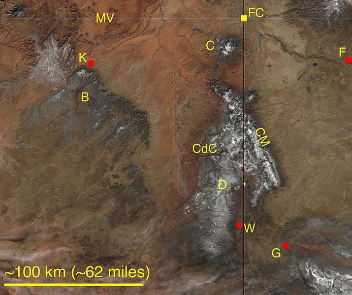
A cropped, labeled, and lower-resolution adaptation from a NASA satellite image, Visible Earth (file GrandCanyon.A2002019.1820.250m.jpg at http://visibleearth.nasa.gov). Parts of northeastern Arizona and northwestern New Mexico, including the Four Corners Monument (FC), are shown. Some higher elevations have a dust of snow. Labeled natural features are the Chuska Mountains (CM), the Carrizo Mountains (C), Monument Valley Navajo Tribal Park (MV), Black Mesa (B), Canyon de Chelly National Monument (CdC), and the Defiance Uplift (D). Labeled towns are Farmington, New Mexico (F), Gallup, New Mexico (G), Window Rock, Arizona (W), and Kayenta, Arizona (K).
اجازهنامه
| این پرونده در مالکیت عمومی قرار دارد چرا که توسط ناسا ایجاد شده است. سیاست حق تکثیر ناسا بیان میکند که «مواد ناسا با حق تکثیر محافظت نمیشوند، مگراینکه ذکر شده باشد». (Template:PD-USGov، صفحهٔ سیاست حق تکثیر ناسا یا سیاست جیپیال استفاده از تصاویر را ببینید.) | ||
 |
هشدارها:
|
تاریخچهٔ پرونده
روی تاریخ/زمانها کلیک کنید تا نسخهٔ مربوط به آن هنگام را ببینید.
| تاریخ/زمان | بندانگشتی | ابعاد | کاربر | توضیح | |
|---|---|---|---|---|---|
| کنونی | ۱۸ ژوئیهٔ ۲۰۰۶، ساعت ۱۹:۴۸ | | ۹۹۰ در ۸۳۰ (۶۴۵ کیلوبایت) | Omphacite~commonswiki | A cropped, labeled, and lower-resolution adaptation from a NASA satellite image, Visible Earth (file GrandCanyon.A2002019.1820.250m.jpg at http://visibleearth.nasa.gov). Parts of northeastern Arizona and northwestern New Mexico, including the Four Corners |
کاربرد پرونده
صفحهٔ زیر از این تصویر استفاده میکند:
کاربرد سراسری پرونده
ویکیهای دیگر زیر از این پرونده استفاده میکنند:
- کاربرد در ceb.wikipedia.org
- کاربرد در cs.wikipedia.org
- کاربرد در en.wikipedia.org
- کاربرد در es.wikipedia.org
- کاربرد در it.wikipedia.org
- کاربرد در www.wikidata.org