پرونده:North Indian cyclone tracks 1970-2005.jpg

پروندهٔ اصلی (۲٬۹۴۳ × ۱٬۶۷۱ پیکسل، اندازهٔ پرونده: ۱٫۱۹ مگابایت، نوع MIME پرونده: image/jpeg)
این پرونده در ویکیانبار موجود است. محتویات صفحهٔ توصیف آن در زیر نمایش داده میشود. |
خلاصه
| Saffir-Simpson Hurricane Scale | ||||||
| TD | TS | 1 | 2 | 3 | 4 | 5 |
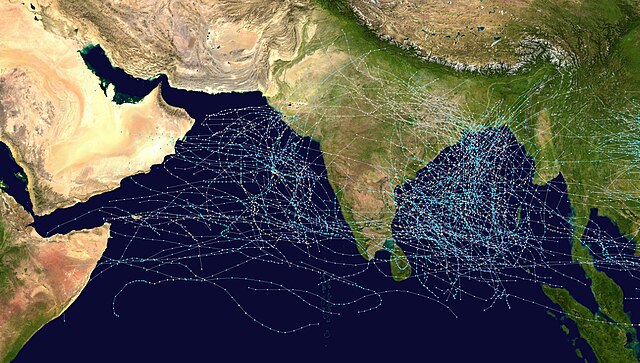
This map shows the tracks of all Tropical cyclones which formed in the north Indian Ocean, or moved into that basin from the northwest Pacific Ocean, from 1970 to 2005. The points show the locations of the storms at six-hourly intervals and use the color scheme shown to the right from Saffir-Simpson Hurricane Scale. Gray points denote unknown strength storms.
اجازهنامه
Created using User:jdorje/Tracks by Nilfanion on 2006-08-16. Background image from Image:Whole_world_-_land_and_oceans.jpg (NASA).
Tracking data for storms is from the Joint Typhoon Warning Center.[1]
| من، دارنده حق تکثیر این اثر، این اثر را به مالکیت عمومی منتشر میکنم. این قابل اجرا در تمام نقاط جهان است. در برخی از کشورها ممکن است به صورت قانونی این امکانپذیر نباشد؛ اگر چنین است: من اجازهٔ استفاده از این اثر را برای هر مقصودی، بدون هیچگونه شرایطی میدهم، تا وقتی که این شرایط توسط قانون مستلزم نشده باشد. |
تاریخچهٔ پرونده
روی تاریخ/زمانها کلیک کنید تا نسخهٔ مربوط به آن هنگام را ببینید.
| تاریخ/زمان | بندانگشتی | ابعاد | کاربر | توضیح | |
|---|---|---|---|---|---|
| کنونی | ۱۶ اوت ۲۰۰۶، ساعت ۱۵:۰۸ | | ۲٬۹۴۳ در ۱٬۶۷۱ (۱٫۱۹ مگابایت) | Nilfanion | == Summary == {|align="{{{align|right}}}" border="0" cellspacing="0" cellpadding="0" style="background:transparent;text-align:center" |- |colspan="7" nowrap="nowrap"| <small>Saffir-Simpson Hurricane Scale</small> |- |s |
کاربرد پرونده
صفحهٔ زیر از این تصویر استفاده میکند:
کاربرد سراسری پرونده
ویکیهای دیگر زیر از این پرونده استفاده میکنند:
- کاربرد در bn.wikipedia.org
- کاربرد در de.wikipedia.org
- کاربرد در en.wikipedia.org
- کاربرد در id.wikipedia.org
- کاربرد در pt.wikipedia.org
- کاربرد در simple.wikipedia.org
- کاربرد در ta.wikipedia.org
- کاربرد در uk.wikipedia.org
- کاربرد در zh.wikipedia.org
- 2006年北印度洋氣旋季
- 2007年北印度洋氣旋季
- 2008年北印度洋氣旋季
- Portal:熱帶氣旋
- Portal:熱帶氣旋/風季
- 2009年北印度洋氣旋季
- 2010年北印度洋氣旋季
- 北印度洋氣旋季
- Template:North Indian Ocean cyclone seasons
- 2012年北印度洋氣旋季
- 2011年北印度洋氣旋季
- 2013年北印度洋氣旋季
- 2005年北印度洋氣旋季
- 2004年北印度洋氣旋季
- 2003年北印度洋氣旋季
- 2002年北印度洋氣旋季
- 2014年北印度洋氣旋季
- 2001年北印度洋氣旋季
- 2000年北印度洋氣旋季
- 1999年北印度洋氣旋季
- 2015年北印度洋氣旋季
- 1998年北印度洋氣旋季
- 1997年北印度洋氣旋季
- 1996年北印度洋氣旋季
- 1995年北印度洋氣旋季
- 1994年北印度洋氣旋季
- 1993年北印度洋氣旋季
- 1992年北印度洋氣旋季
- 1991年北印度洋氣旋季
- 1990年北印度洋氣旋季
- 2016年北印度洋氣旋季
- 2017年北印度洋氣旋季
- 2018年北印度洋氣旋季
- 2019年北印度洋氣旋季
- 2020年北印度洋氣旋季
- 2021年北印度洋氣旋季
- 2022年北印度洋氣旋季
- 2023年北印度洋氣旋季
- 2024年北印度洋氣旋季