پرونده:Ocean drainage.png
پروندهٔ اصلی(۱٬۲۵۶ × ۶۵۶ پیکسل، اندازهٔ پرونده: ۷۵ کیلوبایت، نوع MIME پرونده: image/png)

خلاصه

این map نگاره می‌بایست با استفاده از گرافیک برداری اس‌وی‌جی فایل بازسازی شوند. این چند مزیت دارد؛ Commons:Media for cleanup را برای اطلاعات بیشتر ببینید. اگر حالت برداری آن در حال حاضر موجود است، لطفاً آن را بار کنید. پس از بارکردن یک اس‌وی‌جی، این الگو را با {{vector version available|new image name.svg}} جایگزین کنید.
توضیح
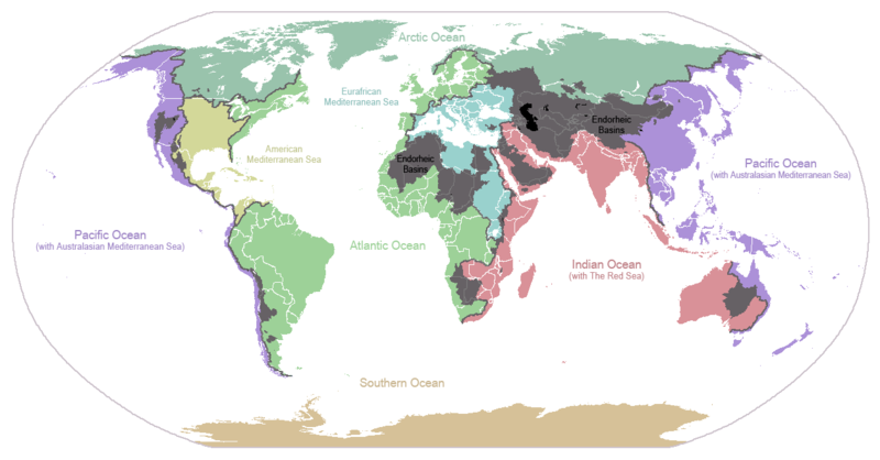
English: I made this map and hereby release it into the public domain. It shows the drainage basins for the major oceans and seas; grey areas are endorheic basins that do not drain to the ocean. Data is from the USGS Hydro1k project; information for Saskatchewan corrected by information from the Commission for Environmental Cooperation -- Citynoise
Description in large font size is used for oceans, in smaller font size is used for mediterranean seas. Only these mediterranean seas are listed which correspond to the definition of german Geographer Ernst Neef: A mediterranean sea is a sea between two Continents. Also found here: de:Mittelmeer --W like wiki (talk) 00:55, 12 March 2011 (UTC)
Français : Carte du monde des bassins versants. Les zones de couleur anthracite représentent les bassins endoréiques, qui ne sont reliés à aucun océan.
Čeština: Úmoří světových oceánů, popř. významných moří či zálivů. Legenda úmoří: fialová - Tichý oceán, růžová - Indický oceán, zelená - Atlantický oceán, azurová - Severní ledový oceán, béžová - Jižní oceán, modrá - Mexický záliv, světle modrá - Středozemní moře, šedá - oblast neústící ve světovém oceánu
تاریخ ‏۲۴ ژانویهٔ ۲۰۰۷‏ (تاریخ اصلی بارگذاری)
منبع Transferred from en.wikipedia to Commons.
پدیدآور Citynoise در ویکی‌پدیا انگلیسی
دیگر نسخه‌ها File:Major endorheic basins.png

اجازه‌نامه

Public domain این اثر توسط پدیدآور آن، Citynoise در ویکی‌پدیا انگلیسی، به مالکیت عمومی درآمده است. این مربوط به تمام جهان است.
در برخی از کشورها ممکن است به صورت قانونی این امکان‌پذیر نباشد؛ اگر چنین است:
Citynoise به هر کسی اجازهٔ استفاده از این اثر برای هر مقصودی، بدون هیچ‌گونه شرایطی، را می‌دهد تا وقتی که این شرایط توسط قانون مستلزم نشده باشند.

سیاهه بارگذاری اصلی

صفحهٔ اصلی توضیحات اینجابود. همهٔ نام‌های کاربر زیر به en.wikipedia اشاره دارند.
  • 2007-05-20 17:59 Bolonium 1256×656×8 (50194 bytes) I made this map and hereby release it into the public domain. It shows the drainage basins for the major oceans and seas; grey areas are endorheic basins that do not drain to the ocean. -- [[User:Citynoise|Citynoise]] == Licensing == {{self
  • 2007-01-24 07:21 Citynoise 1256×656×8 (63359 bytes) I made this map and hereby release it into the public domain. It shows the drainage basins for the major oceans and seas; grey areas are endorheic basins that do not drain to the ocean.
  • 2007-01-24 06:09 Citynoise 1256×656×8 (57358 bytes) I made this map and hereby release it into the public domain. It shows the drainage basins for the major oceans and seas; grey areas are endorheic basins that do not drain to the ocean.
  • 2007-01-24 05:10 Citynoise 1256×656×8 (56360 bytes) I made this map and hereby release it into the public domain. It shows the drainage basins for the major oceans and seas; grey areas are endorheic basins that do not drain to the ocean.
  • 2007-01-24 04:55 Citynoise 1256×656×8 (56373 bytes) I made this map and hereby release it into the public domain. It shows the drainage basins for the major oceans and seas; grey areas are endorheic basins that do not drain to the ocean.

عنوان

شرحی یک‌خطی از محتوای این فایل اضافه کنید
Drainage basins of the world, colored by ocean outlet. Endorheic basins not draining to an ocean are colored dark gray. Continental divides are indicated by dark lines.

آیتم‌هایی که در این پرونده نمایش داده شده‌اند

توصیف‌ها

۲۴ ژانویهٔ 2007

تاریخچهٔ پرونده

روی تاریخ/زمان‌ها کلیک کنید تا نسخهٔ مربوط به آن هنگام را ببینید.

تاریخ/زمانبندانگشتیابعادکاربرتوضیح
کنونی‏۶ اکتبر ۲۰۱۵، ساعت ۲۳:۲۵تصویر بندانگشتی از نسخهٔ مورخ ‏۶ اکتبر ۲۰۱۵، ساعت ۲۳:۲۵۱٬۲۵۶ در ۶۵۶ (۷۵ کیلوبایت)AcidSnowFixed Somalia.
‏۱۲ مارس ۲۰۱۱، ساعت ۰۰:۳۹تصویر بندانگشتی از نسخهٔ مورخ ‏۱۲ مارس ۲۰۱۱، ساعت ۰۰:۳۹۱٬۲۵۶ در ۶۵۶ (۷۶ کیلوبایت)W like wikiInsert Description. Big font size is used for oceans, smaller font size is used for mediterranean seas.
‏۳۰ ژوئن ۲۰۰۹، ساعت ۱۱:۱۳تصویر بندانگشتی از نسخهٔ مورخ ‏۳۰ ژوئن ۲۰۰۹، ساعت ۱۱:۱۳۱٬۲۵۶ در ۶۵۶ (۴۰ کیلوبایت)U7vGuntransparentize background,improve some details.
‏۲۶ ژوئیهٔ ۲۰۰۸، ساعت ۲۰:۴۵تصویر بندانگشتی از نسخهٔ مورخ ‏۲۶ ژوئیهٔ ۲۰۰۸، ساعت ۲۰:۴۵۱٬۲۵۶ در ۶۵۶ (۶۲ کیلوبایت)Citynoise{{Information |Description=added endorheic basins in Saskatchewan. |Source=my own work |Date=July 2008 |Author=Citynoise |Permission=all rights released |other_versions= }}
‏۲۷ نوامبر ۲۰۰۷، ساعت ۱۹:۴۶تصویر بندانگشتی از نسخهٔ مورخ ‏۲۷ نوامبر ۲۰۰۷، ساعت ۱۹:۴۶۱٬۲۵۶ در ۶۵۶ (۴۹ کیلوبایت)File Upload Bot (Magnus Manske) {{BotMoveToCommons|en.wikipedia}} {{Information |Description={{en|I made this map and hereby release it into the public domain. It shows the drainage basins for the major oceans and seas; grey areas are en:endorheic basins that do not drain to the

صفحهٔ زیر از این تصویر استفاده می‌کند:

کاربرد سراسری پرونده

ویکی‌های دیگر زیر از این پرونده استفاده می‌کنند:

نمایش استفاده‌های سراسری از این پرونده.

فراداده