پرونده:South Williamson Kentucky aerial view.jpg

اندازهٔ این پیشنمایش: ۸۰۰ × ۵۳۴ پیکسل. کیفیتهای دیگر: ۳۲۰ × ۲۱۴ پیکسل | ۶۴۰ × ۴۲۷ پیکسل | ۱٬۰۲۴ × ۶۸۳ پیکسل | ۱٬۵۰۰ × ۱٬۰۰۱ پیکسل.
پروندهٔ اصلی (۱٬۵۰۰ × ۱٬۰۰۱ پیکسل، اندازهٔ پرونده: ۸۱۴ کیلوبایت، نوع MIME پرونده: image/jpeg)
این پرونده در ویکیانبار موجود است. محتویات صفحهٔ توصیف آن در زیر نمایش داده میشود. |
| توضیح |
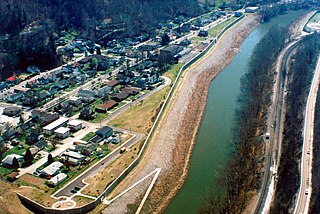
English: Aerial view of South Williamson, Kentucky, USA. The town is protected by a floodwall built along the Tug Fork River by the U.S. Army Corps of Engineers. The river here is the border between Kentucky and West Virginia. The view in this photograph is from the West Virginia side looking south-southwest over the river to South Williamson, Kentucky. |
|||
| مکان | South Williamson, Kentucky, USA 37°40′20.97″N 82°17′4.92″W / 37.6724917°N 82.2847°W |
|||
| تاریخ | ||||
| منبع |
U.S. Army Corps of Engineers Digital Visual Library Image page Image description page Digital Visual Library home page |
|||
| پدیدآور | U.S. Army Corps of Engineers, photographer not specified or unknown | |||
| اجازهنامه (استفادهٔ مجدد از این پرونده) |
|
تاریخچهٔ پرونده
روی تاریخ/زمانها کلیک کنید تا نسخهٔ مربوط به آن هنگام را ببینید.
| تاریخ/زمان | بندانگشتی | ابعاد | کاربر | توضیح | |
|---|---|---|---|---|---|
| کنونی | ۲۲ مارس ۲۰۰۷، ساعت ۰۱:۲۱ | | ۱٬۵۰۰ در ۱٬۰۰۱ (۸۱۴ کیلوبایت) | DanMS | {{Information | Description = {{en|Aerial view of South Williamson, Kentucky, USA. The town is protected by a floodwall built along the Tug Fork River by the U.S. Army Corps of Engineers.}} | Source = U.S. Army Corps of Engineers Digital Visual |
کاربرد پرونده
صفحهٔ زیر از این تصویر استفاده میکند:
کاربرد سراسری پرونده
ویکیهای دیگر زیر از این پرونده استفاده میکنند:
- کاربرد در azb.wikipedia.org
- کاربرد در ceb.wikipedia.org
- کاربرد در ce.wikipedia.org
- کاربرد در en.wikipedia.org
- کاربرد در es.wikipedia.org
- کاربرد در lld.wikipedia.org
- کاربرد در pl.wikipedia.org
- کاربرد در sr.wikipedia.org
- کاربرد در tt.wikipedia.org
- کاربرد در uk.wikipedia.org
- کاربرد در www.wikidata.org
- کاربرد در zh.wikipedia.org