پرونده:Sudan agriculture Landsat.jpg

پروندهٔ اصلی (۱٬۲۰۰ × ۹۰۵ پیکسل، اندازهٔ پرونده: ۲۲۰ کیلوبایت، نوع MIME پرونده: image/jpeg)
این پرونده در ویکیانبار موجود است. محتویات صفحهٔ توصیف آن در زیر نمایش داده میشود. |
Transwiki approved by: w:en:User:Dmcdevit
This image was copied from wikipedia:en. The original description was:
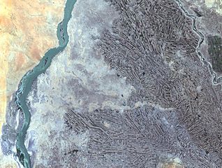
Farming along White and Blue Nile Rivers, near Khartoum, w:en:Sudan
In the Sahara Desert, along the White and Blue Nile rivers lies a thriving agricultural area. As seen in this Landsat 7 image, the farming patterns resemble French long farms, whose long, rectangular shapes allow each individual plot access to water from irrigation canals along the narrow side. The White Nile (left side of image) joins with the narrower Blue Nile (right side of image) a few miles further north at the city of Khartoum, Sudan, home to approximately 1 million of Sudan’s 33 million people. Sudan’s main crop is cotton, a very water-intensive crop for such an arid land. Surrounding Khartoum is the eastern Saharan Desert, noticeable as the reddish area in the upper left portion of the image.
http://landsat.usgs.gov/gallery/detail/384/
این تصویر در مالکیت عمومی است زیرا تنها پدیدآور آن سازمان زمینشناسی آمریکا است که یکی از سازمانهای وابسته به وزارت کشور ایالات متحده آمریکا به شمار میرود. برای اطلاعات بیشتر سیاستهای رسمی حق تکثیر سازمان زمینشناسی آمریکا را ببینید.
|
سیاهه بارگذاری اصلی
| date/time | username | resolution | size | edit summary |
|---|---|---|---|---|
| 21:21, 24 October 2005 | w:en:User:Brian0918 | 1200×905 | 220 KB | Farming along White and Blue Nile Rivers, near Khartoum, <a href="/wiki/Sudan" title="Sudan">Sudan</a> In the Sahara Desert, along the White and Blue Nile rivers lies a thriving agricultural area. As seen in this Landsat 7 image, the farming patterns resemble French long farms, whose long, |
Image description page history
تاریخچهٔ پرونده
روی تاریخ/زمانها کلیک کنید تا نسخهٔ مربوط به آن هنگام را ببینید.
| تاریخ/زمان | بندانگشتی | ابعاد | کاربر | توضیح | |
|---|---|---|---|---|---|
| کنونی | ۱۶ سپتامبر ۲۰۰۷، ساعت ۰۴:۰۳ | | ۱٬۲۰۰ در ۹۰۵ (۲۲۰ کیلوبایت) | BetacommandBot | Transwiki approved by: w:en:User:Dmcdevit This image was copied from wikipedia:en. The original description was: Farming along White and Blue Nile Rivers, near Khartoum, w:en:Sudan In the Sahara Desert, along the White and Blue Nile rivers lies |
کاربرد پرونده
صفحهٔ زیر از این تصویر استفاده میکند:
کاربرد سراسری پرونده
ویکیهای دیگر زیر از این پرونده استفاده میکنند:
- کاربرد در ar.wikipedia.org
- کاربرد در ast.wikipedia.org
- کاربرد در ca.wikipedia.org
- کاربرد در en.wikipedia.org
- کاربرد در es.wikipedia.org
- کاربرد در ig.wikipedia.org
- کاربرد در sr.wikipedia.org