پرونده:Super Pit Mine, Kalgoorlie, Western Australia.jpg

اندازهٔ این پیشنمایش: ۶۰۰ × ۶۰۰ پیکسل. کیفیتهای دیگر: ۲۴۰ × ۲۴۰ پیکسل | ۴۸۰ × ۴۸۰ پیکسل | ۷۶۸ × ۷۶۸ پیکسل | ۱٬۰۲۴ × ۱٬۰۲۴ پیکسل | ۲٬۰۴۸ × ۲٬۰۴۸ پیکسل | ۳٬۰۰۰ × ۳٬۰۰۰ پیکسل.
پروندهٔ اصلی (۳٬۰۰۰ × ۳٬۰۰۰ پیکسل، اندازهٔ پرونده: ۳٫۴۶ مگابایت، نوع MIME پرونده: image/jpeg)
این پرونده در ویکیانبار موجود است. محتویات صفحهٔ توصیف آن در زیر نمایش داده میشود. |
خلاصه
| توضیح |
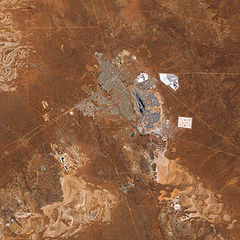
English: The pit that gives the mine its name appears in the centre of the image, and some of the steep pit’s walls appear in shadow while others are illuminated by the Sun. Related mining operations form a rough semicircle on the eastern side of the pit; a cluster of buildings east-north-east of the pit is Fimiston Mill, where ore is processed. Waste dumps and grey-white tailings ponds sprawl over the arid landscape. Tailings are the rocks and chemicals left over after the gold is extracted. Because the chemicals used to separate gold from rock are often caustic, tailings usually pose hazards to human and/or environmental health and must be treated carefully. The metropolitan area of Kalgoorlie, marked by street grids and manicured green spaces, extends almost to the mine’s central pit. An airport, marked by a long runway, appears along the city’s southern margin. Founded during a late-nineteenth-century gold rush, Kalgoorlie, like the neighboring mine, occurs near an area nicknamed the “Golden Mile,” which is considered especially rich in gold deposits. As the beige and reddish colors in the image indicate, vegetation in the area is sparse. |
| تاریخ | |
| منبع | NASA Earth Observatory |
| پدیدآور | Jesse Allen |
Image captured by the Advanced Land Imager (ALI) on NASA’s Earth Observing-1 (EO-1) satellite. Data provided courtesy of the NASA EO-1 team.
اجازهنامه
| این پرونده در مالکیت عمومی قرار دارد چرا که توسط ناسا ایجاد شده است. سیاست حق تکثیر ناسا بیان میکند که «مواد ناسا با حق تکثیر محافظت نمیشوند، مگراینکه ذکر شده باشد». (Template:PD-USGov، صفحهٔ سیاست حق تکثیر ناسا یا سیاست جیپیال استفاده از تصاویر را ببینید.) | ||
 |
هشدارها:
|
| برچسبها | این نگاره برچسپگذاری شدهاست: برچسپها را در ویکیانبار مشاهده کنید |
تاریخچهٔ پرونده
روی تاریخ/زمانها کلیک کنید تا نسخهٔ مربوط به آن هنگام را ببینید.
| تاریخ/زمان | بندانگشتی | ابعاد | کاربر | توضیح | |
|---|---|---|---|---|---|
| کنونی | ۲۲ فوریهٔ ۲۰۱۰، ساعت ۱۲:۱۱ | | ۳٬۰۰۰ در ۳٬۰۰۰ (۳٫۴۶ مگابایت) | Originalwana | {{Information |Description={{en|1=The pit that gives the mine its name appears in the centre of the image, and some of the steep pit’s walls appear in shadow while others are illuminated by the Sun. Related mining operations form a rough semicir |
کاربرد پرونده
صفحهٔ زیر از این تصویر استفاده میکند:
کاربرد سراسری پرونده
ویکیهای دیگر زیر از این پرونده استفاده میکنند:
- کاربرد در ckb.wikipedia.org
- کاربرد در cs.wikipedia.org
- کاربرد در en.wikipedia.org
- کاربرد در fr.wikipedia.org
- کاربرد در nl.wikipedia.org
- کاربرد در www.wikidata.org